In brief: Houston will see a warm, mostly sunny pattern for the next couple of days before rain chances tick up a bit toward the end of the week. These will mostly be seabreeze type showers, so nothing too crazy. They should help to keep highs generally in the low 90s into the weekend as millions struggle without electricity.
Beryl aftermath
Beryl will soon dissipate, but as of this morning it remains a tropical depression moving rapidly to the northeast over Arkansas. It will not be a factor in our weather going forward. Bayous and creeks are quickly returning to normal levels, and coastal waters have retreated. We are left to cleanup, and there is plenty of work to do with CenterPoint still reporting 1.8 million customers with outages, Entergy with 232,000 outages north of Houston, and Texas New Mexico Power 92,000 customers mostly south of the city. Houston will not be as hot as it could be in July, but it will still be plenty hot this week unfortunately.
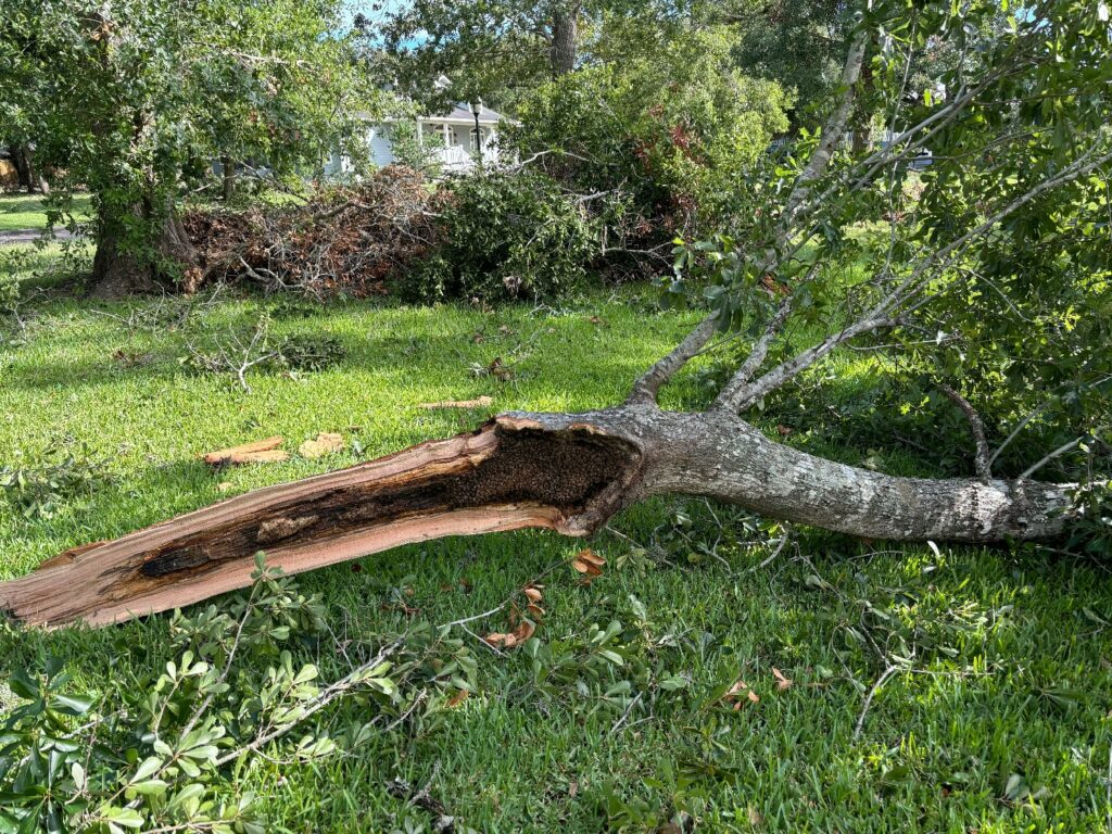
One discovery made at the Berger household is that one of our downed trees contained a huge bee’s nest. I had seen more bees of late near our garage, but I had no idea this was there. We’re working to get the hive moved to an apiary. Pretty wild stuff.
Tuesday
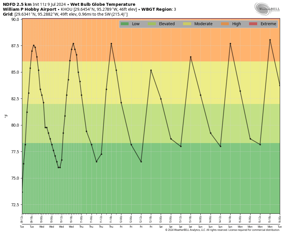
Skies will be mostly sunny today, with high temperatures in the low 90s. Winds will be light, generally from the northwest. Given the sunshine and high humidity levels, we’ll see “high” heat levels today based on wet bulb globe temperatures, so please drink plenty of water and take a cold shower or bath if possible to cool down. Low temperatures tonight will drop into the upper 70s, providing some modest relief. Rain chances will be near zero today.
Wednesday
Another mostly sunny day with highs generally in the low 90s. Rain chances will again be low, with light northeasterly winds.
Thursday, Friday, and Saturday
These days will see a mix of clouds and sunshine, this should continue to help keep high temperatures in the low 90s. Rain chances will be better on each of these days, with the influx of some moisture from the Gulf of Mexico. We’re talking perhaps a 30 to 50 percent chance each day of mostly light to moderate showers and thunderstorms. Total accumulations for most areas through the weekend will probably be on the order of one-half inch of rain, or less. Nighttime temperatures should continue to remain in the upper 70s.
Sunday and next week
More sunshine and lower (but not non-existent) rain chances arrive next week. We can probably expect highs in the low- to mid-90s, with nights trending a bit warmer.
Good luck to everyone today with storm recovery!

Thanks Eric for all you and Matt did to keep us informed through this hurricane! While dealing with your own messes!! You guys are the best!!
Wow Eric! Those are a lot of bees. Thank you and Matt for Everything! I appreciate you doing the helpful Q&A’s for the community. I apologize for my reporter (long) question.
You both please get some rest and I am so grateful for Space City Weather and now The EyeWall.
That’s a LOT of bees!!
Thanks for all you and Matt do for Houston, Eric. Your service is greatly appreciated.
It’s good that your source of bee hive is leaving property. We’ve been trying to move out bees in our shed wall. No matter what we do, they seem to return every three years or so. Even had a bee whisperer last time. Yet watching them flying around shed right now.
Thanks for reliable weather reports
Love your short story about the Bee Hive. Love it when you interject personal, real life stories, it gives your Weather Report an interesting touch and makes me smile. Thank you for your Weather Report, especially this time of year. I’m a Houstonian living in Southern California with a daughter living in Houston so your weather report means a lot to me. You guys keep up the excellent work you do. Thank you! 😊
Well, you certainly got the better end of the weather deal!
As a beekeeper I applaud your effort to get them safely rounded up. Thanks
I don’t think there are many other options for something like this. Nobody in their right mind would take a chainsaw to that, and I doubt pest control would go near it either.
Regarding the Ike-ish large number of customers out of power, I suspect it has a lot to do with the increase in population density. Near the city (e.g., Heights), numerous lots with a single family home (and native trees) were bulldozed and 6-16 townhomes built in its place. Additionally, numerous 300+ resident apartment complexes have been built in the last decade. This provides a lot more customers to be affected in the same area. Furthermore, I think the removal of trees (especially in recent construction/ developments where the lots are cleared first) creates an additional impact. In my neighborhood, we noticed that where a significant number of trees were removed (for whatever reason), several of the remaining trees fell down in the derecho and Beryl. Where there were more trees (which acted as a buffer system) there were fewer downed trees. Just an observation, but it makes a lot of sense that lone trees (esp pines) have to take more stress alone than if they’re surrounded by other trees that can buffer the winds.
This is a great point, and probably part of the reason. It’s been 16 years since Ike so a lot has changed development wise in Houston. I just would have hoped that in the interim we would have learned from the storm and hardened the distribution system. This was a test, not even a particularly stiff one relative to Ike, and the transmission system largely failed. Sub-opitmal to be sure.
I read an article not that long ago, possibly in the last year, about how trees, and hedges, can be utilized as windbreaks to help protect structures from damage during storms, so your supposition does make a lot of sense. It got me thinking a lot about the trees in my neighborhood and what danger or protection they offer my own home. I think someone in the previous post also mentioned trimming services thinning out trees too much, which is a concern I have with the sycamore in my very small front yard, the tree service I had come out three years ago hacked it to s**t, and then CenterPoint had a crew here in May who disfigured it even more. I’m at the point where I really think it needs to be cut down, but the price quotes I get are ridiculous.
Thanks for all your great reporting for Beryl. So sorry about your trees and bees!
It is about 2 a.m. on Wednesday morning, and in Timber Creek in Spring Branch we just had a pretty violent T’storm that dropped another 1.72 inches (!) of rain and knocked out power. The rainfall figure is per Harris County Flood Warning System website for gauge #2250. The map shows we’re in the middle of a small hot (wet?) spot. October can’t get here soon enough for me.
Thank you, Eric and Matt, for what you do and all that you have done to help us through difficult, stressful times of severe weather, especially hurricanes. It is of immense value and I know that you spend alot of time, thought, and life doing this, which helps so many. God bless you!
Thanks for all the work SCW did over the last week. A couple of things learned from this storm.
1.) Reaffirmed my fear of storms forecast to go to our southwest. More often than not the high pressure steering them west degrades over time allowing them to move north and east. Historically many storms have hooked off to the north and east.
2.) Having a backup generator is a must even if it’s a small one. If you can hook it up to your breaker box even better.
3.) Generators drink more gas than you would expect.
4.) Have a good chainsaw. I have an expensive Stihl that never seems to work when I need it so I am going to be diligent with my maintenance of both my chainsaw and generator. Run them both completely out of has before storing to keep them from gumming up carburetors is a good practice. A cheap Harbor Freight electric chainsaw is better than you think and is rather impressive.
5.). Most importantly this storm re-affirmed my belief in running from a category 3 or bigger storm. After this one in my location I am not staying for anything over a category 2. After a few hairy hours with gusts in the 80-90 mph range I want no part of anything over 115…
on point #2 — have a licensed electrician do the connection to the breaker box Folks who have generators just plugged in are backfeeding the local grid and putting lineman at significant risk. They have to work more slowly in order to work safely.
More expensive? yes. Worth it? yes, please.
Absolutely a licensed electrician is best. However in Texas a home owner can do his/her own electrical work as long as it is up to code. When doing this make sure your main breaker is off to avoid back feeding the grid and putting lineman at risk. It is not an overly complicated process and their are Youtube videos that will show you how to do it to code.
I’m in complete agreement on number 5, I live out in Sealy and this is the first hurricane that I’ve experienced, going back to Alicia in 1983, which has had the eye pass this far west. Have to say, not a fan, and I kept thinking Monday morning, while hearing the wind howl outside, any storm taking a similar track and stronger than a cat 2, I’m outta here and staying with friends in either Austin or the DFW area for at least a few days.
We’ve lived in the NE Houston area since 2001 and have therefore experienced Rita, Ike and Harvey. As far as we can see, there are more trees and fences down than we can remember with any of the other storms. The wind seemed stronger this time. Any opinion on why that is?
Rita hit well east of Houston and Harvey well to our southwest. So their winds were not a factor for most of us in the area. The NE quadrant of Ike hit just east of us in Bolivar. Had it followed a similar path to this storm we would have been on the bad side and experienced much worse. As far as track was concerned Beryl was a worst case scenario for the greater Houston area.
Worse case track is eye hits downtown, and storm surge on east site thus has nice path up Trinity Bay to flood downtown and Galveston is underwater too. Beryl was not on worst path. I think. Thank you Lord.
Thank you for the reminder of the various paths! We left town with Rita (wrong direction and was worse off for it), but I do remember what it was like during Ike and Harvey. The wind with Beryl was surprising for me. Expected it to be less. Live and learn!
I too want to thank Eric, Matt, Dwight and all others that kept us informed during Beryl. It was scary when I lost electricity and TV coverage but I was so comforted to have Space City updating the real deal. You guys made a big difference in lives of many and I thank you from the bottom of my heart!
Thank you, Eric and Matt.
Thank you, Dwight.
Thank you to everyone working hard to restore power, internet, and other services.
Looking forward, my thoughts are as follows.
#1 When landfall is 3 days away (72 hours) if in the Cone the worry. For Beryl this was at Yucatan. Before this Cone was off. #2. Storms won’t veer left from current path, but apparently can veer right at past 45 degree angle from 3 day point and landfall point, this 45 right veer seems the edge of danger zone at 3 day point. #3. Hurricanes passing thru Yucatan lose enough energy they’ll be a Cat 1 or 2. #4. Storms that never cross land will be more unpredictable, can bloom into 4 of 5. #5. Each 10 miles inland the power felt drops by quarter, there’s a reason to avoid coast, so seniors Conroe or North can relax. #6. By simple odds before 72 hours to landfall, with so many other areas to go, a hurricane is not worth worry. #7. Odds on Gulf of feeling tropical storms winds is once each 5 years, Cat 3 winds once every 15 years, when moving to Houston or South of Houston these are odds to consider. I COULD BE WRONG. HA.
Not sure having to check for eyewall posts isnt a bit annoying, especially when audience is stressed, so having 2 websites has some drawbacks.
Add my thanks to the SCW team for everything. I’m thankful for having power to run the AC and fridge: everything else is pure gravy.
My Internet is out but not complaining at all and my thoughts are with my fellow friends and Houstonians to get their own power back soon.
Like others have said, I’ve adjusted my personal “stay or go” decision based on prior experience with Alicia, Allison, Ike, Harvey, and now Beryl. Each storm plus the population change affects this equation. Anything over a Cat 3 or a storm that may stall over us: leave. The mess will be here when I get back.
This hurricane was a BERYL of laughs! 🙃
We escaped from Kingwood three years ago to an area between Houston and Waco. Couldn’t deal with the stress of being so near the Gulf coast. Still read SCW, best weather reporting anywhere!
It will be a happy day (in the next two years or so) when I get 200+ miles away from the Gulf Cost. About had it with the climate here.
I’m out of here in a few months. I can’t wait to leave and am counting down the days. I’ve absolutely had it with this place. I’ve never hated living anywhere as much as I hate it here.
Bees in the trees? How about fire ants inside the mail box? And the fence post.
Eric, a belated thank you to you and the SCW staff. Go ahead and take a few days off for a vacation in southern Caribbean…. er, uh, Colorado.
Thank you both for the coverage during Beryl.
However, I am now (when power is completely restored) ready to hear that high pressure will park on top of Houston until October
Anything to say about the lightning storm and downpour last night in spring branch? Knocked the power back out. I thought rain chances were near zero.