In brief: Expect winds to whipsaw across Houston for the next few days as we go from a southerly flow to a northerly flow and back to a southerly flow between now and Friday. Overall, temperatures continue to look mild, with Thursday looking to be a splendid day.
Tuesday
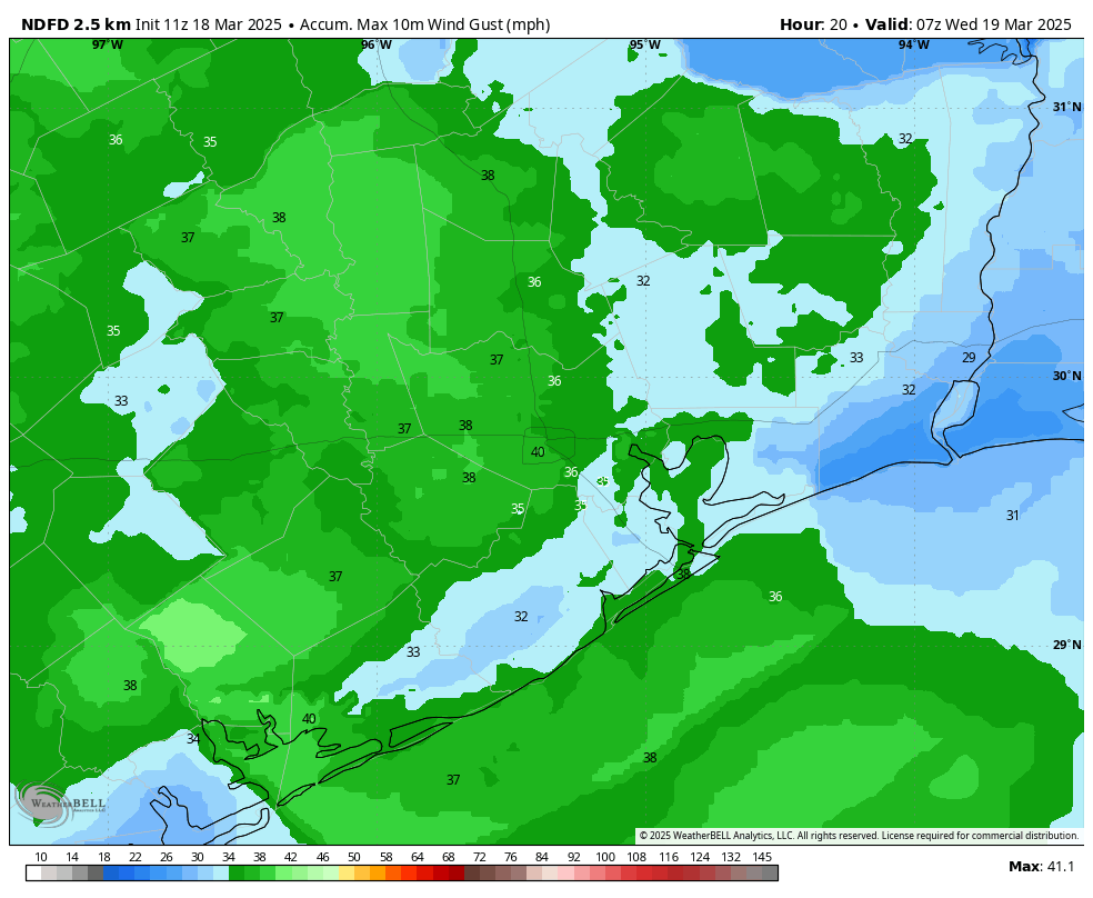
Low temperatures have only fallen to about 60 degrees this morning, and we are going to see warmer weather for a couple of days. The southerly flow will be especially pronounced today, with a tight pressure gradient causing winds to reach sustained levels of about 20 or 25 mph, with gusts up to 40 mph this afternoon. Highs will reach about 80 degrees this afternoon, with a few clouds developing later today.

If you’re headed out to the rodeo, you’ll want to hold on to your hat. Look, I realize I’ve already used that joke this year, but it’s been windy, ok? Although winds may slacken just a bit, they’re still going to be pronounced this evening, along with temperatures in the 70s. The influx of moisture will help keep overnight lows in the upper 60s.
Wednesday
Wednesday morning will be fairly warm and humid, with mostly cloudy skies. Winds should also have finally died down. But it won’t last as a front sweeps in from the northwest during the late-morning hours, likely reaching the coast around noon or shortly after. There is the barest chance of some rain along with the front on the east side of Houston, but I expect a dry passage for nearly all of us.
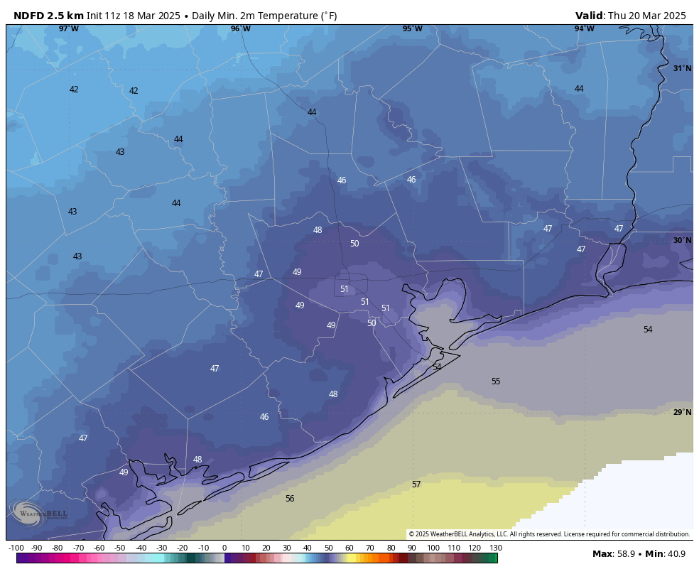
Highs will be in the upper 70s with sunny skies during the afternoon. And the winds—they’ll have reversed direction, and we can expect gusts of around 20 mph during the daytime, increasing to about 30 mph on Wednesday night. This will create “red flag” conditions for at least western areas of the region, meaning the winds and dry soils will be conducive to wildfires. With the drier air, lows will drop to around 50 degrees on Wednesday night in Houston.
Thursday
This looks to be a splendid day, as it lies in the period between a frontal passage and the return of the onshore flow. Look for highs of around 70 degrees, light winds, sunny skies, and low humidity. Lows on Thursday night will again drop to around 50 degrees in Houston, with cooler conditions for inland areas.
Friday
Another sunny day, with highs in the low 70s. However we’ll likely see some modestly strong southerly winds. Lows only drop into the lower 60s with the warmer southerly flow.
Saturday, Sunday, and beyond
After temperatures mostly in the 70s this week, this weekend and beyond will likely see a warmer pattern, with highs in the lower 80s. We may see one or two weak fronts in the extended forecast, but overall, we should see warmer days and mild nights. Alas there is not a huge signal for rainfall, which we could use right now.

Tropical Storm Risk announced they came out with improved data sets, as they were relying on NOAA data (now they’re looking elsewhere). Looking at the regions previously covered by NOAA, it looks like 2/3rds of the ENSO readings would have had to come from NOAA as well (should have realized).
I know there’s a spring anomaly associated with March ENSO reports, but it did look more skewed towards La Niña than this winter’s predictions. I sure hope that’s not the case. We dent need another La Niña making friendly with the CAG.
Very concerned with the accuracy of future ENSO reports.
(I’m not criticizing NOAA. I’m very grateful to them, esp now, when they’re working harder than ever.)
I thought the trend was towards ENSO neutral now? Maybe I misread something.
No, you’re right, it’s still Neutral, but just barely, with La Niña seeming to gain ground. It looked like ‘much more La Niña’ than the previous ENSOs (at least to me).
La Niña seemed to give free reign to the 2024 CAG, and the big storms seemed mostly CAG spawned (Helene, Milton) or CAG accelerated (Beryl).
With the SSTs so high and the data sets so off now, IDK what to think.
I’m looking for a way to gauge.
I haven’t seen a MTD for March. February Nino 4 region was 81.54 degF and January was 81.66F down from 82.53 in December. So the mild La Niña is slowing down but no uptick as yet thru February. I really can’t believe they would publish erroneous data – what I’ve seen is delays and changed websites as they reconfigure. Maybe Dan is more informed if so tell us what you’re seeing with data
Not neutral. Mild La Niña. The DJF index is -0.6C. Neutral zone begins at -0.5C. So it’s getting close to neutral as you say. But trade winds still blowing west. Old patterns may not be as valid anyway. ‘We’ll see’ is the best phrase for this forum.
TSR maps shows ENSO Regions 1+2, 3, 3.4 & most of 4 to be under NOAA stewardship. TSR is changing their dataset acquisitions, the implication being that NOAA is sliding.
“Previously, TSR relied on advisories from the National Hurricane Center (NHC) and Joint Typhoon Warning Center (JTWC) to produce datasets. We have now enhanced this by incorporating regional advisories from areas covered by the JTWC, providing more frequent (every 3-6 hours) and accurate storm position, track, and forecast data.”
They advised they are using the JMA (Japan), IMD (India), BoM & La Reunion.
While this diversity is good, the ENSO modeling still comes primarily from NOAA, thus my concern for data sets. Not that they would would intentionally produce erroneous data sets, just that their information has been hobbled.
So…are we getting a hurricane soon? Asking for a friend.
Ok, now I understand your comments from last week. I really think all the modeling needs to be AI anyway and the commercial sector is in right front of that. I know this because of their biz announcements. It’s time for a weather prediction upgrade as the patterns aren’t going to be ‘off the shelf’ anymore with planet warming moving faster.
Hi BF, no hurricanes coming this month or next just tight isobars and wind. lol.
AI has many good uses, but it’ll be ill-employed here. It should have been used to make systems better in conjunction, not in exclusivity.
NOAA was decimated so it would partially fail. First they gut, then they wait until the storms do the damage. Then they offer up “The AI Solution”, packaged and delivered. Desperate people will take it, only it will now be in the best interest of the shareholders and what they want, not conducted for the safety of the public, but for the Sharpie Swipers. Presto, monetized weather.
Never free and unbiased again.
Well, if Harvard can be the Rice of the northeast, Houston can become the Windy City of the south. Well, that’s the problem. It got REALLY windy here in 2008, 2019, 2021, 2024….