In brief: Houston will continue to see very warm days, with highs generally in the upper 80s, for the rest of the month into early November. The only difference is that the modestly lower humidity we have seen this week will increase next week, and things are going to feel really humid for this late in the year. Rain chances remain possible later next week, but we’re unlikely to get the widespread drought relief we need.
Thursday
Calm winds and temperatures down near dewpoints in the lower 60s this morning are creating conditions to produce at least some patchy fog across parts of the area, but it will recede as temperatures warm up. We’re going toward the mid- to upper-80s for most locations today, with sunny skies and light easterly winds. Dewpoints will be low enough that the air feels at least somewhat dry outside. Low temperatures tonight will drop into the mid- to upper-60s for most locations, with the coast warmer as usual.
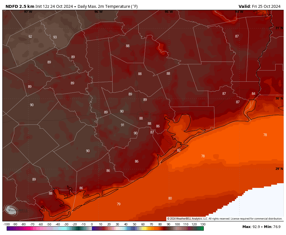
Friday
We’ll be a bit warmer on Friday, with much of the area in the upper-80s and a few locations potentially hitting 90 degrees. Sunny skies will prevail. The air will also feel a bit more humid, so this will be a pretty warm day overall. Lows on Friday night will only drop into the upper 60s.
Saturday and Sunday
Dewpoints drop back slightly for the weekend, so the air should again feel slightly drier. Days will still be quite warm, in the upper 80s for most locations. However, nights will be back into the mid-60s for most of Houston away from the coast. Skies will be almost uniformly sunny, so you should have no concerns about outdoor plans, except for atypical heat for late October.
Next week
We’ll see a continuation of warm, sunny days to start next week, with highs again in the upper 80s on Monday and Tuesday, and clear nights with lows in the upper 60s. However, the onshore flow should really start blowing and going at some point on Tuesday—we may see some fairly pronounced southerly winds—and this will act to boost humidity. We’re then likely to see partly cloudy and humid days during the second half of next week, with highs remaining in the upper 80s and nights in the low 70s. This is really incredibly warm for late October (including Halloween) into early November.
The only upside is that rain chances will finally return to the forecast by Wednesday or so. However, the overall likelihood of rain probably remains in the 30 percent range. In his post yesterday, Matt mentioned the possibility of a cold front by around next weekend, and there’s still a healthy chance of a front by Sunday (November 3) or Monday, but it’s something I would consider far from locked in.

I now declare, Houston has 180 days of Summer; May-Oct. You’ve been warned. Leave now, or forever hold your crying.
It’s my right as a Houstonian to cry all I want!
What’s ups with the crying nonsense! It is how Houston weather roll! Unpredictable! Getting used to it! It will not change no matter how much crying boohoo you do!
I’ll be leaving, alright, but it looks like I’ll have to endure one more Houston summer. And hurricane season.
I miss you, boots & sweaters…
October has slowly but surely transitioned into a summer month over the years. 😕
It is called Octsummer.
Or Yucktober.
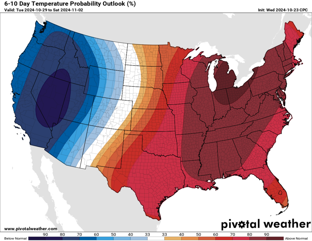
I don’t understand what that map is indicating. It looks like it’s going to be over 90 in Michigan next week and super cold in LA. Deceiving to say the least.
If you read the map’s title and legend, you’d realize that it’s looking at Temperature Probability, not just temperature.
Its variation to normal historical temp, the darker the blue the lower the temp to normal and vice versa. It’s not saying the west coast will be cold, its saying it will be quite a bit cooler than normal, just like it will be quite a bit warmer than normal here.
It’s not a temperature forecast, but a probability of above or below average temperatures–two different items.
It is a confusing map. Those aren’t temperatures, they are percentages. The map indicates LA has an 70ish% chance of being colder than normal for this time of year, and Michigan has a 80 – 90% chance of being warmer than normal for this time of year.
Sorry, I didn’t see all these other replies. 🙂
It’s only confusing if you don’t actually read the title/heading.
😑
Go home, Summer, you’re drunk. 🙁
I follow a California weather YouTube channel and indeed the upcoming pattern change on the Pacific Coast and Intermountain West is looking to be very dramatic. There is an expectation of a notable fall-off in maximum and minimum temps even at lower elevations, and measurable snowfall in the Sierra Nevada and transverse ranges north of LA. In short, an abrupt transition from an extended summer-like pattern to an anomalously cooler and wetter pattern. I had my hopes up that as this system moves east we would see similar dramatic effects.
Dropped to 59-60 this morning in the League City area. Perfect fall weather here in SE TX. October feels great in the Deep Dirty South folks. Enjoy it!
MJO coming back around? 2 blocking lows become 2 blocking highs on the left and right coasts…11/3 ish. We finally get the low to come down to our latitude.
It’s time to rethink my Chewbacca costume.
Is it too early to make a prediction where this October may rank in terms of all time warmest for Houston?
It is a little to early to know for certain, but it will definitely fall in the top 5 warmest October’s on record. In fact the current average temp for Houston this October is 76.3. If October ended today than we would be tied with 1962 at the 4th warmest on record. The hottest October on record was 2004 with a mean of 77.5 degrees. Based on the forecast, we may come really close to tying or breaking that record this year. The cooler nights are the only thing that may save us from breaking that record because the days have averaged even warmer this October than the 2004 October. The current average high so far this October is 90 degrees even. That is ridiculous.
Agreed, and thanks.
I am a bit confused. Summer of ’23 we were in a strong El Nino, and were stuck in a very hot and dry weather pattern. Now we’re in a weak La Nina, and it seems the same conditions exist. I understand there are other factors at play, but it just seems odd.
El Nino and La Nina don’t really influence the Summer very much here. La Nina does increase our chances of getting hit by tropical activity because of the lack of windshear it causes over the gulf. So that is one way our Summer can be influenced by La Nina. But most of the time the summer can go either way regardless of the ESNO.
We feel effects of La Nina and El Nino much more during the fall, winter, and spring because of their effects on the jet stream. During El Nino we typically experience cooler and wetter weather once fall hits because the jet stream buckles more over Texas, sending us rain making low pressure systems more often. This is exactly what happened last fall and winter. Last spring was very stormy likely because of the background influence of El Nino.
La Nina has the opposite effect during the fall/winter. The jet stream tends to stay north of Texas in an arch like configuration. That keeps the colder air and rain making systems north of Texas for longer periods of time. This keeps Texas warmer and drier than normal, much like what is going on right now. However, that doesn’t mean we won’t ever get a drop of rain or have cold days this winter, it just means that the rainy/cold days will happen less often. The affects of La Nina have notoriously sparked many of the droughts we have had in Texas throughout history including the historic 2011 drought.
And you are right, there are other factors at play like the Arctic Oscillation that can defy what you typically expect with La Nina or El Nino. However the AO tends to have a more temporary effect, lasting days or weeks while the ESNO is a long term trend that can affect the overall outcome over a 6 to 8 month period.
Thank you Joseph. That was definitely helpful.
No problem 👍
I’m confused, too. I hope someone can explain!
I have said it before, summer in Houston usually goes to Halloween. Anything cool weather before that are just teaser fronts. As a kid we judged if summer was over by whether you wore shorts under your costume or long pants. One special year an actual cold front came through on Halloween and I remember my mom making me wear a jacket over my costume. It has been this way for the many decades I have lived in Houston
I agree, and that is why I always say that fall doesn’t truly start here until November. That is when our average highs are usually in the 70s most days, with nights in the 50s. We can get strong cold fronts in late October sometimes, but that is not every year, and even then, it is still hot through most of October, with highs in the mid to upper 80s most days.
Some interesting data on the weather history for Houston on Halloween. From weather dot gov…
Houston (1891-2018)
Average High: 76.6°F
Average Low: 57.1°F
Average Rainfall: 0.24″
Warmest
88°F 2004
88°F 1977
88°F 1972
88°F 1919
87°F 1992
Coldest
29°F 1993
35°F 1980
39°F 1925
40°F 1917
41°F 1991
Wettest
5.14″ 2015
3.84″ 1909
2.49″ 1941
2.26″ 2018
2.05″ 1974
Interesting, thanks!
I remember 2015 well.
I remember ’93 well. I was in a vacation cabin in the Piney Woods and the heat refused to work.
Add in a bit rain here and there and I’ll take this weather year round!
nasty weather all the time