In brief: What goes up must come down over the next week or 10 days, as Houston rides a roller coaster of temperatures. The other big story will be rain chances, which will be high on Wednesday, and then an ongoing possibility through the weekend. Unfortunately, we still don’t have great clarity for when it might rain this weekend, but we’ll tell you when we do.

A fundraiser thank you
Just a quick note to very sincerely thank everyone who contributed to our annual fundraiser, which is now over. Matt and I are so appreciative of all the support, and we can’t wait to bring the city and its good people multiple cool fronts next July and August. Because that’s our job, right?
Tuesday
We’re starting today at the bottom of the roller coaster. Low temperatures this morning range from the upper-30s well north of Houston to the 50s down near the coast. Winds are generally light, from the north, and should veer to come from the east. Skies will be mostly sunny today—generally if you want to see sunshine for the next week today is the today. It’s going to be mostly cloudy from here on out for awhile. Highs will reach the mid-60s for most locations. Lows tonight will be about 10 degrees warmer than Monday night, dropping into the mid-50s.
Wednesday
We’ll reach the top of the roller coaster on Wednesday, with warm and muggy air, as highs reach the low 70s. Beginning early Wednesday, we’ll see the possibility of some sprinkles or light showers. Some slightly stronger showers, and possibly a few thunderstorms, are possible on Wednesday afternoon and evening as as the region feels the influence of a coastal low pressure system. A decent chance of showers remains in the forecast through the overnight hours, and most of the region is likely to see perhaps 0.5 to 1.5 inch of rain, with higher accumulations possible.

Thursday and Friday
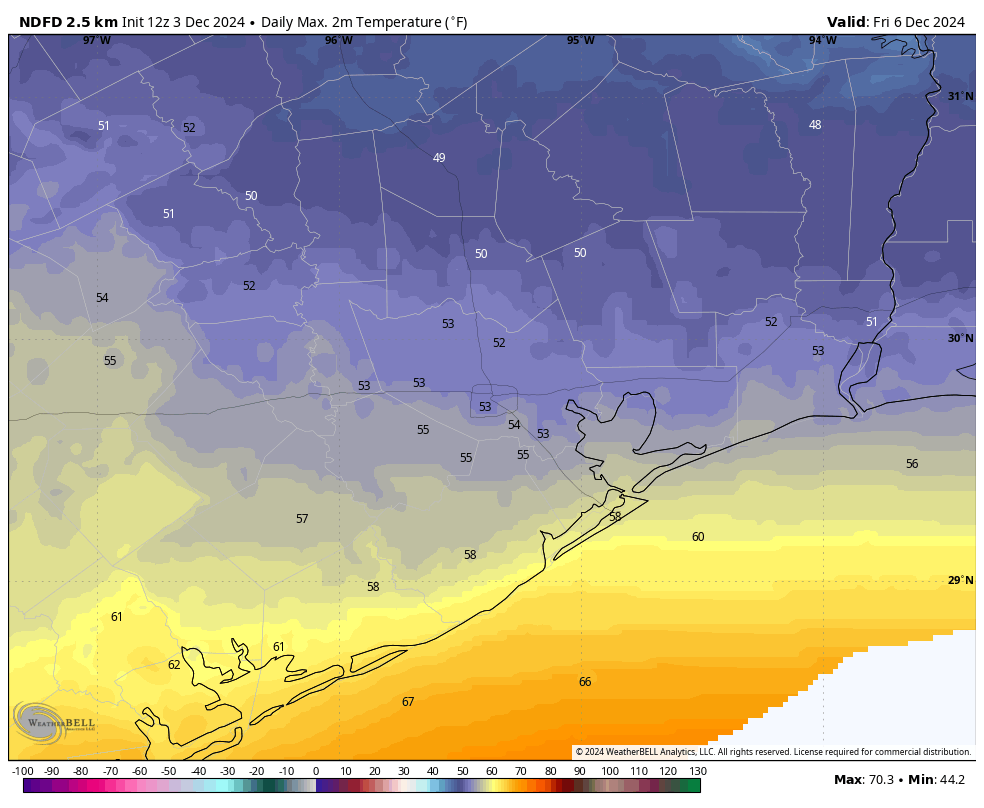
So rain chances are dialed back somewhat on Thursday. I generally expect mostly cloudy skies and highs in the 60s. Here’s where the forecast, itself, turns cloudy. The most probable outcome is the arrival of cooler and drier air in response to another front. The uncertainty is that there is still a slight chance that the effect of this front is blunted somewhat, so we may not get that cold. However, my expectation is that lows on Thursday night will generally drop into the 40s on Thursday night, with Friday being a chilly day, with highs in the 50s. All throughout we’re going to see a slight chance of rain, not any kind of storms, but light rain most likely. Lows drop into the upper 40s on Friday night. Probably.

Saturday and Sunday
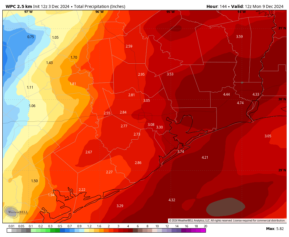
I’m still not particularly confident in the weekend forecast beyond generally cloudy skies. My expectations are for highs in the 60s both days, with lows in the 50s. So what about rain chances? I’m going to hedge and say they’re about 50-50 each day. At this point, accumulations look to be higher on Sunday, but honestly the forecast is really difficult to call right now. So we’re going to have to fine tune things in the next day or two. I know it’s the not the answer you want, but it’s the answer you’re going to get right now. But some rain is definitely coming this week and over the weekend. I expect most of the area to pick up between 1 to 4 inches through Sunday night.
Next week
Monday is probably a warmish day, with highs in the 70s, and perhaps some sunshine. After that we’re likely to see another front, that will help cool us down and may actually bring more sunshine. But we shall see what lies on the tracks ahead.

For those of us who are waiting for the cool cloudy days, the leaf raking weather. Although they haven’t turned and fallen yet.
Our time has come!!!!!
Rejoice, sweater heads!
yuuuuuck
I feel like I’m the only person who saw the “upside down rainbow” over Hobby Lobby off the Grand Parkway in Katy yesterday. So I googled it, and it’s actually a circumzenithal arc. Pretty cool!
Wish I knew how to add my photo!
Me and my daughter saw it in pearland! So cool.
Looking forward to Friday and Saturday – I’m off both days and a great chance to catch up on back-logged yard work. 🙂
Please make it raindeer 🦌
Good one! 👍👍😅
Wow no 80+ degree days with record breaking highs in the 10 day forecast? Pinch me I must be dreaming.
Follow-up for Jos: thanks for the well reasoned response last night! Still thinking it’s a local issue. Maybe the geography of the nearby hot SW plateau combining with the 2-3 degf of planet warming in the last 40 years. Undeniably fast, but does it also drive the humid-drought tendency here since 2020. Or is just bad luck on the local weather patterns like in the 1950s. Too soon to say but that is the $$ question. Just hot or “hot house earth”.
Go 300 miles east of here you get the same macro weather factors but not the dearth of rainfall vs the norm…..
Typing this stuff and seeing other thoughts helps me think thru what’s going on.
Yeah. A couple of my older country cousins were telling me about the drought in the 1950s in Washington County.
No problem, and I completely agree that it is most likely a local issue primarily caused by the SW plateau. Even with or without global warming, the warm, dry inversion or “cap” from the SW plateau would still frequently bring droughts to Texas. To be honest, if the Earth cooled significantly, then droughts would actually get even worse in Texas because the cooled Gulf waters would not evaporate nearly as much water to turn into precipitation. The weather is complicated lol.
It’s hard to keep up because time flies so fast, but we usually end up in some form of drought at some point most years, at least where I live along the coast. The reason the far eastern half of the U.S. typically gets more rain than us is that the desert mountain cap simply doesn’t affect that region of the country—at least not nearly as much as the South and midwestern states. I don’t think it can reach that area. The Southeastern states always get a more direct flow from the Gulf ahead of most cold fronts, while here in Texas, we almost always have that battle between humid gulf air and dry, warm desert air in the mid-levels of the atmosphere. During the 1950s, the dry cap won most of the time. We also had very powerful ridges of high pressure settle over Texas through several of the 50s summers, very similar to our recent summers.
It looks like flooding is possible in some areas tomorrow? Thoughts on what areas?