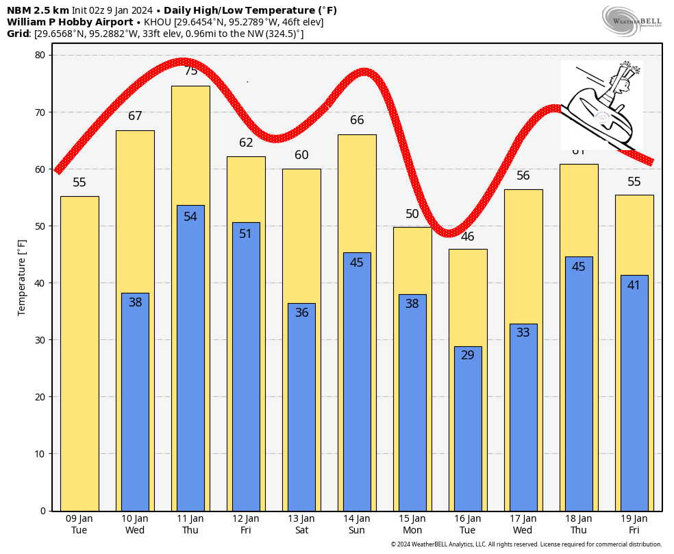
Good morning. After the rains, the thunder and lighting, the pea-sized hail and yes, even a tornado north of Houston, we finally come to some calmer weather. Skies will be sunny today, with no rain or storms in sight. But there will be plenty of wind and cold air. If you don’t like that, well, fine. Houston’s weather will be changing significantly on almost a daily basis for the next week at least. Cold today. Balmy by Thursday. Near freezing by Saturday morning. Warming up again on Sunday. Then very likely freezing by early next week with our coldest weather in more than a year.
Buckle up, y’all, because its rollercoaster time in the Bayou City.
Tuesday
It’s a blustery, cold morning outside. Temperatures are generally in the low 40s across the metro area, and when you layer wind gusts of 25 to 30 mph on top of that, it feels like the 30s outside. Strong northerly winds will persist for much of today. Skies will be sunny, but with the colder flow highs will only reach the mid-50s. Skies will be clear tonight, with lows generally in the 30s, though above freezing for the majority of the metro area. Winds will slacken some overnight, finally.
Wednesday
Pretty quickly, the flow will reverse itself, coming from offshore. This will allow temperatures to warm into the mid-60s, with plenty of sunshine. Clouds will start to build on Wednesday night, as lows drop only into the mid-50s.
Thursday
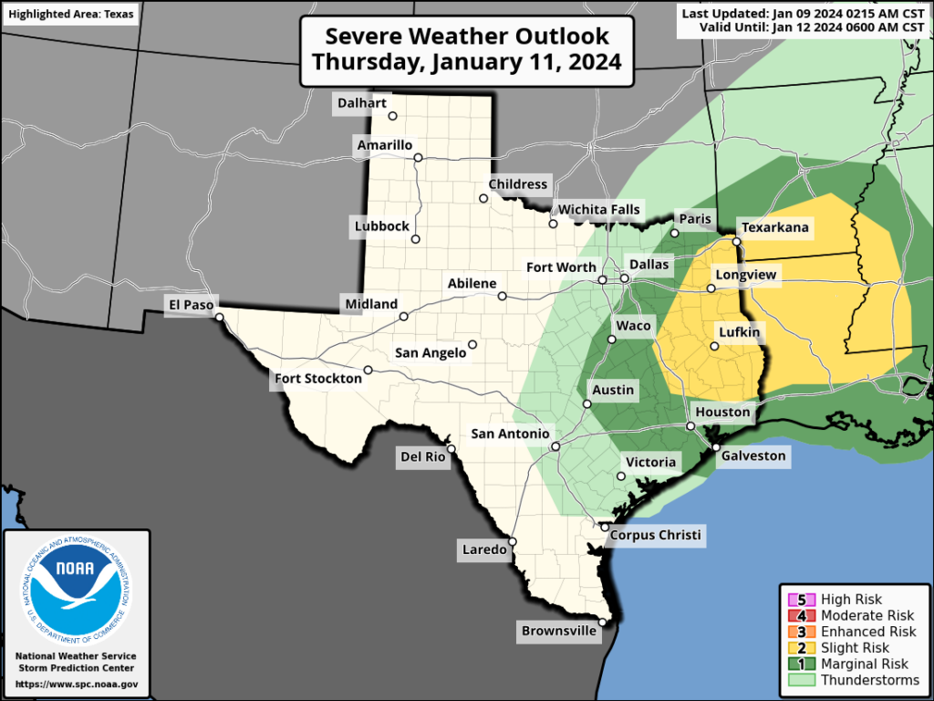
This will be a fairly warm day, with an ongoing southerly flow. Skies will be mostly cloudy, with highs pushing into the mid-70s. The region’s next front will move into the Houston region some time on Thursday night, and there could be a broken line of showers and thunderstorms accompanying it. Right now things don’t look too serious for Houston, but there is a risk of severe weather to the northwest of the metro area, including northern parts of Montgomery County.
Friday
This should be a sunny day, and will have colder temperatures. Look for highs of around 60 degrees. Friday night will be cold, with lows dropping into the 30s. A light freeze is possible for inland areas on Friday night with clear skies and light winds.
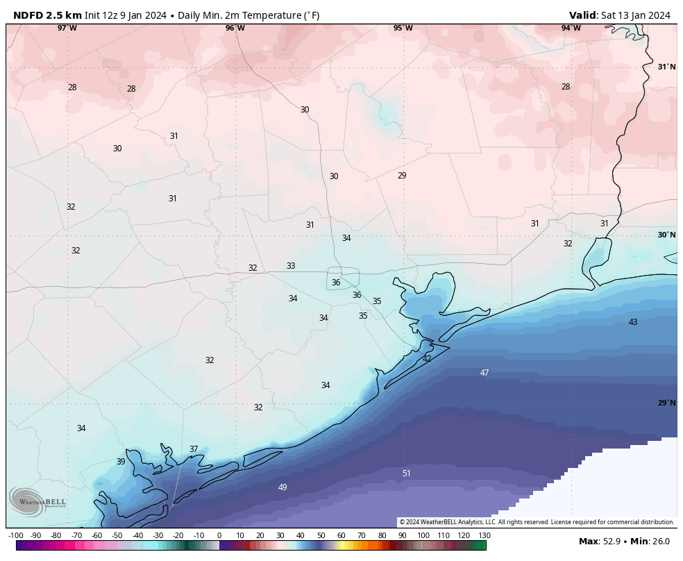
Saturday and Sunday
This will be a sunny and cool day, with highs of around 60 degrees. As the onshore flow returns on Saturday we’ll see overnight temperatures moderate on Saturday night. For my fellow marathon runners, there’s still a bit of uncertainty about Sunday morning. But my best guess for start-line conditions is temperatures in the low- to mid-40s, with mostly clear skies. Throughout the morning temperatures should warm into the 50s and then reach 60 degrees around noon. I’m not worried about any rain, but there should be some wind, perhaps 10 to 15 mph from the south with some higher gusts. This will nudge dewpoints up, but it won’t be anything too uncomfortable. The next front arrives Sunday night.
Next week
Much colder weather is on the way, starting next Monday. There are some key questions such as how cold is it going to get? And is there a chance of snow or sleet on Monday? In terms of temperatures, there’s a solid chance that Houston drops into the mid-20s and sees a hard freeze. I don’t feel overly confident in that, but it’s a distinct possibility. I’ll dig more into that tomorrow, when hopefully there’s some more forecast clarity, and precautions you’ll need to take. We also can’t rule out some freezing precipitation, but overall chances look fairly low for that. In any case, our region’s coldest weather in more than a year is on the way.


I think I see a fundraiser graphic for a T-Shirt and additional slogan with the rollercoaster!
Will the cold stuff coming in early next week have anything to do with a ‘sudden stratospheric warming’ event that was mentioned recently?
🌬 ❄❄❄
This wind is so annoying, the howling and roaring and the worry of a tree falling onto the house, as well as all of my trash can tipped over, and branches and twigs all around the yard. Hopefully it won’t get too cold because I have Zone 9A plants that might not survive. The USDA in all of its wisdom revised its hardiness zones, even though the winters here are colder than they used to be.
Thoughts and prayers, Jason.
Winters are not colder than they used to be. Not even close. But have we had surges of extreme cold? Yes, and it’s terrible for the plants. But a few days of extreme cold in the winter doesn’t change the fact that the average winter temperature is warmer overall.
However, the annual minimum temperature, which is what hardiness zones are based on, has been frustratingly (for my garden) low the past several winters.
Never a dull moment with weather like this. But, who better to have on a weather roller coaster ride than Eric and Matt? Let the shrieking begin.
It wouldn’t be a Texas Winter without a temperature rollercoaster. lol
I leave Thursday for MX, return Tuesday afternoon. My plants! Do I cover tomorrow? I’m inner loop, Marathon runs right by our street. Please advise!
Lorita, this from the Weather Channel – agreeing with Eric on this:
Mon 15
AM Clouds/PM Sun
41°/22°
24%
N 20 mph
Tue 16
Mostly Sunny
38°/26°
0%
N 13 mph
Covering plants with freeze cloth will be a necessity.
Why does the weather app on my iPhone show 3 lows starting Sunday that are in the low 20’s and upper teens and yours doesn’t? Does th window come from a different source or is it a different Interpretation of the same source info?
Wunderground is saying 23F Tuesday morning – and that’s in Clear Lake.
If so, say goodbye to your plants….
Lol.. sad though. So sorry 😔
I noticed what looked like a bunch of dirt on my truck this morning. I see it on other people’s vehicles as well in my area in Brazoria County. I wonder if the cold front blew in a dust cloud from West Texas or something.
It was certainly nice to have a cold front arrive here yesterday while it was still daylight and we could witness the weather change right before our eyes. It was just before 5:00 when I went out to walk around and by then the wind had picked up and had begun to switch from the south to the south west and also getting stronger. I went in to check the radar and then after going back out to do a little work in the garden the wend continued switching clockwise and now from out of the west. It was then at 5:25 when the sky got very dark and right after that the front hit. The tree tops began to bow down low and the wind turned cold immediately. After calling my wife out to witness this change, the winds began blowing so hard that limbs were blowing out of the trees. It’s been such a long time since we’ve been able to witness a frontal passage and I’m really grateful for that.
My truck was covered this morning as well, Joseph. Kingwood area
Wow, it must be some West Texas dirt that got kicked up in all that wild wind yesterday. It’s the only thing I can think of.