In brief: There will be some showers this morning south and east of US-59 to the coast. Some thunder is possible. No severe weather is expected. The rest of the forecast through Monday and Tuesday is quiet and turning hotter.
We have a few showers southwest of Houston that will push in this morning. The steadiest rain will be south and southeast of the city, areas that saw a bit less action yesterday. We then clear out and dry out for later and tomorrow, Sunday, and Monday. Highs will nudge into the 90s with lows slowly increasing through the 70s into next week.
Trying to make sense of Thursday
This will be a different post than typical. I want to walk through what happened yesterday from a forecaster’s perspective. About 750,000 customers remain without power this morning, and because of the extensive, widespread damage, this number will very slowly decrease today and tomorrow. Some may be without power until next week.
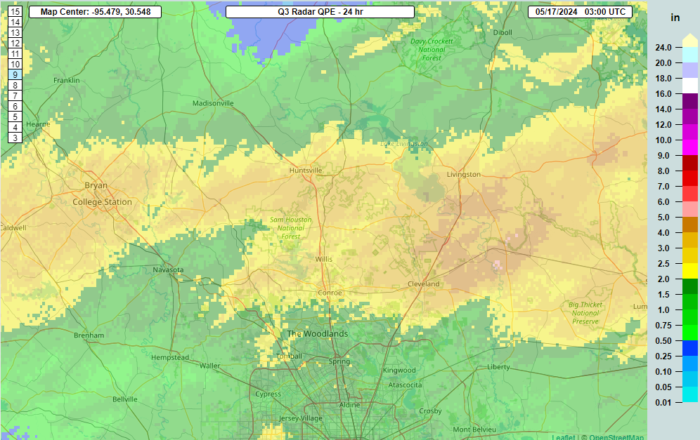
So how did we get here? As a refresh, here is Eric’s post from yesterday morning. We were all really focused on the threat for heavy rain, and with the high risk in place yesterday to our north, that shouldn’t be a surprise. In fact, 4 to 5 inches of rain did fall as expected, basically north of highway 105 through Conroe.
Eric did note the severe weather and correctly underscored the chances of wind and an isolated tornado. The Storm Prediction Center had the right idea on severe weather yesterday too. But again, I think most of us the significant messaging was heavily focused on the rain.
Through most of yesterday morning, not a whole lot seemed to change. Eric, Dwight, and I met up for lunch at a Pappas BBQ but not the one we originally planned on, which, thanks Apple Maps. Or Google Maps. Who’s to say? Anyway, we touched briefly on the day’s weather but were not particularly concerned about anything else happening. We checked radar while leaving and all looked good.
I got back to my desk and noticed a few people pinging me about a Reed Timmer tweet discussing rain-wrapped tornado potential in southeast Texas. Reed’s a good guy and a very smart meteorologist, but he also has tons of enthusiasm. His brand is to dominate and never stop chasing. My first reaction admittedly was to roll my eyes, but then I checked out the HRRR model, one of our hourly updating high-resolution weather models. Indeed, it lit up with supercells by 2 PM. But it was 2 PM. And there were no supercells.

So clearly it was overdoing it, and it would be necessary to watch subsequent runs to see what changes, as well as radar to observe the evolution of the storms. I decided to look at some other data, and I was surprised to see that despite clouds, haze, and mist (or even a heavy drizzle at times), the atmosphere was extremely unstable over the area.
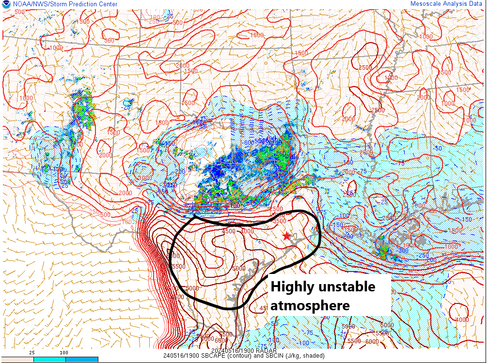
And when you would dig deeper into the models, everything pointed to severe potential. But we also just went through this a few days ago with a major hail threat that basically failed to materialize with any consequence in Houston. In that case, we had the same situation in theory: Impressive instability and an atmosphere primed to rock. As a meteorologist, you look at this two ways: We just came off a semi-bust and you need to make sure you are more confident in something than normal before pushing it, and secondly you also can’t deny that the ingredients were there. A tornado watch was issued, which was a little surprising, though given the parameters there was no good reason to argue much against it.
When I looked at model data, it appeared that any supercell risk would track from the southwest to northeast. I even highlighted a cell around Spring at about 4:25 that I thought was showing signs of trending toward something more meaningful. I went to pick up my oldest from school and came back intending to help him do some homework. Even by about 5:10 or so, it seemed pretty straightforward: A line of severe storms with gusty, maybe localized damaging winds was moving through Brenham and toward Waller County, and we’d probably get it through by 7 or 8 PM and that would be that.

Things began to change quickly about 15 minutes later. It was evident that rotation had begun to develop on the leading edge of the bowing line near Bellville. And it seems likely that a tornado may have been put down just east of there shortly thereafter. That is not necessarily uncommon. It’s often how we get our tornadoes locally, but it’s usually brief and disappears after 5 to 10 minutes. And indeed, the rotation weakened some, but at 5:35, it flared back up again, just west of FM 359 to the east of Bellville. Thereafter, it absolutely exploded near Pine Island and just south of 290 in Prairie View. By 5:40 to 5:45, we clearly had a problem.

I have been in Houston for about 12 years as of this week, and I cannot recall seeing this type of velocity signature (the right-hand panel) show up in this area. When you see this as a meteorologist, it either means a violent tornado is underway, or destructive winds are probable. At times, it looked like you could pick out a debris signature on radar that would essentially confirm a tornado, but it never took off, which led me to believe that this was becoming a major straight line wind event.
I had been texting a bit with Justin Ballard, the Houston Chronicle’s fine meteorologist earlier about the tornado watch. We both expressed some skepticism it would produce. He texted me at 6:07 in the middle of this saying, “Yeah, that doesn’t look like a bad decision after all.” Yes, many of us talk to one another. Yes, we occasionally have opinions on things.
Anyway, this continued to march east-southeast and slowly expand. At this point, it becomes straightforward: Monitor it and warn and clear. I had posted to Twitter in a tone I very, very rarely ever use. I don’t throw around language like “Treat this like a tornado” very often. We had gotten very few damage reports up to that point, but the radar was indicating 110 mph winds down to about 2,500 feet. By 6:23 PM, radar showed 120 mph winds down below 2,000 feet approaching Oak Forest. Does all that reach the ground? No. But a lot of it can. It also made me gravely concerned for the downtown high rises.

We’ll find out more today and tomorrow about specifics on damage and what was a tornado or straight line winds. Whatever the case, this was one of the most ferocious storms I’ve ever seen. This was a smaller scale version of what occurred in Iowa a few years back, when they had 140 mph winds down to about 1,000 feet but over a wider area. Whether or not this gets classified as a derecho will remain to be seen. I think it probably falls just short of that metric because of some discontinuity in the damage report path, but honestly, does it matter? It will take time to pick up from this one, and we hope our readers are safe. A major kudos goes out to the many media meteorologists and NWS meteorologists that assisted in keeping as many people safe and informed as possible. Saving lives is rarely a literal thing for a meteorologist. I am thinking that it was for many last night.
I’ll close with a bit of a sobering note: Hurricane season begins in about 2 weeks. What many of you witnessed last night would be experienced not over a few minutes but over several hours over a large area if a truly potent hurricane found its way into the Houston area. By living in this region, you have to accept the risks associated with that. We know a lot about flooding. Most of us know about surge. Very few knew about wind and what it’s really like. Many do now. Use this experience to inform your preparation for hurricane season just in case. Houston has been through an absolute meat grinder of weather disasters in the last 10 years. Candidly, it sucks, but we should know enough now to prepare for the next one.

It was very surprising how the timing was so off. By yesterday morning, the thought was the storms would approach by 1-3pm. Then it pushed back to 5pm. Then 6pm. Then after 8pm. Well, come 6pm it was here in sugar land. But it seems like it had weakened some as we did get a pretty good gust at the start of it, then some heavy rain. But ‘my’ storm didn’t seem to fit the bill for all the alerts I received. And that’s not a complaint! It’s just still so odd to me how weather predictions can be so far off with today’s technology. Regardless, keep up the good work!
The biggest challenge I’ve read about from recent years is that because of how unstable and powerful modern weather events can become even with the incredible technology, it can be hard to predict what will happen because we have never seen events like these. Most of what we predict is based on prior events but we are into new territory of the completely unprecedented.
I wonder what it will be like in Texas in 10 or 20 years.
Pretty simple, instability of conditions do that.
In Richmond, TX we went from a forecast and radar reading that suggested we would get a little rain, then no rain, then heavy rain, then no rain, then a ton of rain, and all of this transcurred in a span of about 75 minutes.
And that’s simply the nature of a beast of a storm, one that even caught guys like Matt and Eric a bit of guard.
What good work? They blew the call. It’s also said to see them talk about twitter in a way that they don’t realize it’s 2024 not 2011. You guys are really on that platform? It really shows how out of touch you are. Again, great job blowing the call guys. Another reason I rarely listen to these folks.
Wow, you managed to take a weather event and meteorology and turn it into a political post about twitter.
So…being a long, long time Sci Guy follower I’ll ask the obvious.
I guess Katy should have evacuated?
(Yeah, I had to.)
No, but maybe Montrose (where I live) should have!
Counting myself lucky that I got power back about 3:30. And living far west side (almost to Katy) I induldged the bas humor. Stay safe, sir.
We all appreciate you so much.
Yawn.
Thank you. Could you say something about straight line winds? I have lived in Houston for 68 years and am not familiar with them.
Think about pouring water out of a pitcher onto the floor. When the water hits the floor it flows away from the spot the where the stream is hitting the floor. Straight line winds are the core winds of the thunderstorm being forced down to the ground and spreading out at high velocities. Notice how cold the wind was? It originated from 40 to 50K feet up.
And DCAPE values were quite high. I suspect not enough weight was given to this aspect.
Is that different from wind sheer? I don’t hear people saying that phrase anymore.
Thank you for this update. The information you gave here is factual and timely. Hurricane-like conditions scare the hell out of me, but knowing what may happen is helpful. To you, Matt and all the meteorologists, keep up the excellent work!
Nice post mortem. The storm sure had derecho like DNA, and it kept producing down I-10 through LA and into the coastal waters east of there.
A similar (impact wise) storm occurred in our area May 20 1983. https://www.ncei.noaa.gov/pub/data/swdi/stormevents/pub-pdf/storm_1983_05.pdf
Thank you for sharing this, Bill! Interestingly, also in a weakening strong El Nino scenario too.
That May 20, 1983 storm is the one I referenced to you on Twitter recently. This year has a similar feel to ’83
I love how you go back and review what was off from predicted and share that with us. It’s not easy to predict severe weather like this. You guys do a great job! Thanks for all the updates!
Hi Bill, thanks for sharing! I certainly hope retirement is treating you well.
I remember that one. 50 mile an hour winds. The Weather Channel (which was still new at the time) talking about Tennessee and Kentucky and other places and not once mentioning Texas.
Thanks for the break down. Where was the heads up about a tornado- the touchdown you mention nr Bellville was on our property. It’s ok to talk tactics and data and strategy but none of that helps when you are under the stairs with terrified animals and a tornado is chewing up your property.
Great replay of how this all fired off yesterday Matt! As the saying goes “Knowing is half the battle!” It was a good reminder what a wind event would be like if we are unfortunate enough to have that happen here again.
Thank you for this. How much of storms like this can be reasonably attributed to climate change? Should we expect storms like this to become more common?
Of course it is! Severe thunderstorms never occurred until nasty little humans showed up in their SUVs. Honestly the biggest problem are these deniers and their misinformation campaigns. Because of them, it will probably happen every week going forward.
?, As the Talking Heads said, try and make sense.
What the Talking Heads sang was “stop making sense.”
I bet they heard the opposite with “Don’t Worry About the Government” too which would explain the climate denier thing.
Your sarcasm is incredibly disingenuous.
Nobody is saying that storms like this never occurred before the industrial revolution when we started pumping greenhouses gases into the atmosphere. What we’re saying is that the frequency of storms of the intensity is unprecedented. And it’s not just storms; it’s wildfires, it’s snowstorms, it’s droughts, it’s rising sea levels.
If you’ve paid attention to any forecasts for the hurricane season this year, we’re expecting a record-breaking number of named storms this year. And recording-breaking natural disasters have become the norm over the last couple of decades.
You don’t have to believe that climate change is real, but your belief or disbelief doesn’t change the fact that climate change is real and we’re gonna have to buckle up and get used to storms of this severity being a regular thing, because it’s certainly not going to be getting any better.
Short answer, yes. Warming atmosphere and sea surface temperatures carry more latent heat energy. Accept this and prepare for extreme events to be more common.
Either way – lots of trust in the region’s meteorological community after yesterday, seems like the misses have been piling up over the last few years.
Wouid you please comment on your thoughts about possible manipulation through microwaves? Thank you.
The use of microwaves had no discernible effect on the proliferation of yesterday’s storms. There. That’s all you need to know.
Hmmmm, now that you say it I did cook a Hot Pocket last night around 5:30. Sorry, Houston 🙁
I find a microwave to be useful for cooking popcorn.
As for the use of microwaves to manipulate weather, I have no reason to believe that is happening.
A great candid debriefing. I told my spouse this was a good refresher for hurricane season. The pictures this morning of Downtown look a lot like the morning after Ike. Let’s hope last night was the closest we get to hurricane force winds this season.
I think Reed “DEBRIS!” Timmer goes against the basic principle of your blog, “enthusiast “ is putting it mildly.
Yes it is putting it mildly, but that is in character of the basic principle.
Reed does have a doctorate in Meteorology and is correct far more than not…
You need to eat better bbq
As someone who was present for the BBQ (and the Apple Maps debacle) I can attest: The BBQ was just fine. No notes.
Thanks for the excellent analysis, Matt! That’s a great meteorological education in a five minute read. I would love to see more of this type of analysis after major weather events (which alas, seem more frequent lately). I appreciate all of the work of Space City Weather.
I was lucky enough to make it back home to Splendora from Houston, before it got too bad. My father works downtown at Kinder Morgan, and was called into work because of the blown out windows. He said it looked like an atomic bomb had gone off, and there was glass everywhere!! Just a good reminder to stay weather aware, and also prepare for hurricane season.
My wife looked up from reading your downtown-windows warning tweet
“He…wait…he never types that”
Exactly
Well done 1) having the years-earned communicative capital and 2) using it perfectly
DCAPE values were pretty high, higher than typical for this region. Was this something not weighted heavily enough?
You guys do a great job keeping us informed about what’s going on with the weather. Plus, you do it in terms we laymen can understand. Thank you!
Thank you for the reminder to Houston newcomers that last night’s winds would’ve continued for roughly 8 hours, had it been a direct hit from a hurricane. If you own your home, the next few weeks will be a good time to get your roof checked and make sure everything is okay. This is also the time to start putting plans in place for what you’ll do in an extended power outage or if you don’t have safe drinking water. Or if you don’t have any at all. Be sure to also get trees trimmed. A big reason why so many trees came down in Ike was because it had been 25 years since Alicia and people either didn’t know or had forgotten.
The small positive in all this is that at least with a hurricane, you usually have a few days of lead time to get things in place or evacuate, but you won’t have time to buy a generator or get an arborist out to your home.
Alicia was 40 years ago, not 25.
When Ike hit (2008), it had been 25 years since Alicia hit (1983).
Thanks for this post, Matt. I have two nieces that live in the greater Houston area, and one of them has only lived there a few months – she was scared to death last night! Her Mom (my sister) messaged me from Yakima, WA, and asked if I could provide some information sources to her daughter. I sent her the NWS Houston/Galveston website address, and you and Eric’s blog post link! As you noted in the last paragraph of this post, WIND is a huge factor in today’s climate paradigm. My studies of ice storms and their damaging impacts on electric utility infrastructures over the last 25 years led to the creation of the Sperry-Piltz Ice Accumulation Index, or SPIA Index in abbreviate. Steve Piltz, NWS Tulsa MIC, and the great folks at the Oklahoma Climatological Survey Office in Norman, assisted me with this Index development 17 years ago. Its center piece is WIND! Thanks for all you do, Matt & Eric!
Sid Sperry
President & CEO
SPIDI Technologies, LLC
Website/aSubscriptions: SPIDItech.com
Email: [email protected]
Guthrie, OK
1) big fan of the website and the app
2) forecasting is hard
3) mother nature can be bigger and meaner (0.001) than we generally think (0.999)
Each experience is a Learning one and we add to our base knowledge going forward if we pay attention to the scientific details gathered. Thank you for the great dive into details that add to your knowledge base and ours also. We don’t need to have been Boy or Girl Scouts to know “Be Prepared”! This is becoming more and more important in a climate this is becoming more and more extreme.
Thank you, as always, to Eric and Matt. Their mid-storm updates are extremely helpful to make sense of ongoing severe thunderstorm and tornado warnings, where the NWS warnings can be hard to interpret location/direction.
This is a foreshadowing of the instability and fuel in the air all around us. Are you remembering last year’s solstice storm?
In 1970, Hurricane Celia hit Corpus. ‘No big deal’, everyone said. So they didn’t leave. Schools kept going (the kids were headed home as the winds came in). Parties started roaring. But as Celia approached, she stopped in the GOM off the coast and gathered strength. Then she slammed in, devastating Corpus. One building was fine, the next was gone, like a giant slammed a fist down. Roofs were peeled off buildings like an invisible can opener was at them. They think now that some of those were microbursts. The winds were like a thousand, angry, unending banshees.
(1) The SSTs of the GOM, BOC, Caribbean and MDR are hotter than any other time since current records began. Off the charts. Chart parameters will have to be extended out. That’s hurricane food.
And, in the recent years, since mid 2010s, storms are both: (2) rapidly intensifying (Ida, Idalia, Ian, Otis, etc) and (3) not slowing down upon approach to land. There are also more (4) petrochemical aerosols in the air of the GOM, which seem to expand out the storm canopies.
Both Katrina & Rita were 5s in the GOM, but both slowed down upon approach to land and hit as 3s. Imagine if they HADN’T. Now the picture becomes a little clearer.
(5) There will be no El Niño to cap off those developing storms this year, like last year. Now we have La Niña, who is more than happy to let these storms grow as big as they wish, like gremlins in a candy store, greedily stuffing their faces.
Harvey was mainly just rain by the time he bounced up to Houston. (6) But when a hurricane’s primary energy is wind, you’re in serious trouble. I can’t even hear the wind anymore without my CNS going into high gear.
And since we were all burned on evacuations during Rita, myself included, we best take EVERY single precaution possible NOW, while we can if we’re planning on staying, because we are all sitting ducks.
I was in the Timbergrove area on TC Jester when this blew threw. From a breeze to 100 mph winds in minutes.
The damage from downed trees and power lines is worse than Hurrican Ike. The oil derrick advertising tower at Tommie Vaughn Ford in the Heights came down crushing vehicles parked below.
I live downtown high rise and had just gotten in my car to run an errand. I got the tornado warning push alert and shrugged it off but decided to check your Twitter account. Based on your very direct post, I got out of the car and eventually sheltered in the bathroom with my terrified pup. My block downtown was lucky.
Thank you for being transparent in your posts and analysis and also knowing when to clearly communicate when things get serious. I know it’s lots of pressure on you. Thank you for all you do.
Thank you all at Space City Weather. You are fantastic!
I was at work in Houston close to fifth ward on liberty road. Union Pacific rail road and we definitely got hit by a tornado. Heard it coming seconds before it hit. Lots of damage and rail cars blown over in Englewood rail yard. Super scary.
Oh wow, I used to live in 5th Ward and always remembered that no matter how bad most storms were we were usually spared. Yikes
We all knew that there was the possiblity of severe weather coming into town in the afternoon. That was enough info to do with it what u want. Furthermore, we all know that summer and early fall has the potential of hurricanes. That too is enough info to do with it whatever u want as well. Buy a generac, a regulator generator, evacuate, stay, complain, or whatever your little hearts desire. Not sure what else many of u folks want. Geez Louise!
Looks like a rain wrapped tornado?
https://www.reddit.com/r/tornado/comments/1cts4g4/tornado_going_through_cypress_texas_nw_houston/
Thanks for the detail explaining what happened. You are always the first place I check during severe weather threats, and that will not change.
Can anyone tell me why the sky turns a green hue when tornados are near? I was in Seabrook when I got the tornado watch. The sky wasn’t green yet.. 5 mins later light rain and a green ominous hue was in the sky. I’m originally from Kansas where farm land is abundant so it’s easy to see 5-10 miles down the road. It always turned green there too.. and then u would see a tornado off in the distance.
This is why I’ve stopped following this site so closely and defintely stopped using it as my only weather source. Yesterday, at 6:30 p.m. all hell is breaking lose and there’s nothing on this site except for an old outdated forecast. You guys have missed severe weather in Galveston & Brazoria county several times this past year or more when everybody else got it right. I know that’s a hard message – but here’s the deal: y’all are so concerned with NOT being hyperbolic or sensational, but have you considered that sometimes your soft and soothing forecasting is missing the opportunity for real and timely alerts of dangerous weather? It helps NO ONE to tell us what happened after the fact. I used to share this site with people all the time, but I’ve stopped doing that because the predictions are erroneous too often. I’m sure your fans will come for me now, but I feel you need to know that people need to hear an accurate forecast with all of the probablilites even it seems hyped. Weather is crazy. I’d rather be prepared for the WORST, than not given the news at all.
OK, so did the sites that you follow that aren’t SCW get it right?
Yes.
Respectfully, this is a free weather blog that provides forecasts of what to expect weatherwise over the next several days, updated generally once every weekday morning. The authors do often provide updates when notable events are unfolding, but they also repeatedly advise people to pay attention to more up-to-the-minute sources when severe weather is forecast. By volunteering to supplement your weather forecasts with additional local sources, especially for areas so far outside of Houston, you’re doing exactly what you’re supposed to be doing anyway.
And yesterday’s forecast mentioned the likelihood of severe weather including the possibility of tornadoes. You asked to be informed of the worst case scenario and were.
Sadly weather forecasting is always a double-edged sword.
On one side, you can routinely make very serious, strongly-worded warnings about incoming weather. If it doesn’t pan out (or only pans out for 3% of the population) you end up with people calling you hyperbolic and accusing you of scaring people or overestating the danger of a storm. This will backfire to a point where people stop taking their meteorologists seriously. It becomes a boy-who-cried-wolf scenario.
The other side leads to what you’re describing: where people who ended up in the path are wondering how something like this could not be foreseen, or was perhaps not warned enough.
To their credit, Eric and Matt have been very upfront and honest about how difficult forecasting is. They have done an amazing job breaking down the threats we face and always let us know when it is hard to pinpoint timings and locations. They emphasize that for the vast majority of people, the weather will be loud and angry at worst, but for a select few it will be severe. No other meteorologists that I know of spend the time explaining the science behind how these things develop, and while we can’t all absorb that knowledge, it does make sense to learn what you can so that when you look at a radar image or read a post here, you can think about what to expect for your part of town specifically. In truth, this is also just a very difficult time of year to make forecasts: the air is unstable, fronts collide, parts of the city saw maybe a couple inches over the past month while others saw 20in.
I can tell by their posts that Eric and Matt take feedback like yours seriously and it’s fair to question why they were off if they truly were trailing away from their peers, but I completely disagree with the idea that it “helps no one to tell us what happened after the fact” because I learn so much from these breakdowns, and I don’t see any other meteorologists criticizing and evaluating their own work in front of us for transparency like they always do.
I agree with you Clavem. I used to really like SCW but they are now often wrong. Continuing to create confusion by saying severe weather “north of I10” when it’s really “north of Harris County” is frustrating and “hype”. When they predict bad weather that never formalizes in HOUSTON, they lose (have lost) credibility when we do have a severe event like yesterday. Perhaps they need to enable push notifications on their app because, to your point, it helps no one to read a soft, incorrect 12 hour old post. I’ve started using the Accuweather app and find it to be correct most of the time.
I work outdoors so SCW is an invaluable tool for me when it comes to planning. I visit several other weather websites and I can assure you no-one gets it correct all the time. The risks were highlighted by SCW in the morning update. I think with the nature of weather being what it a warning that it is possible is all we can hope for. Forecasting he exact timing, strength and location of these storms is still beyond our capabilities.
He literally said they were tweeting out warnings as it was happening. They’re not going to post here on the blog about a tornado warning because it probably takes too long to write up and post when tornadoes are moving through so quickly. Their forecast for the day warned of possible severe weather and tornadoes. Tornado warnings went out. I personally was monitoring the radar online and was as prepared as a person can be for weather like this. In the end, weather forecasting will never be 100% and it’s best to gather information from multiple sources. I love this blog and rely on them, but I also use my weather app, NWS alerts, local radar, and follow KHOU on the tv or Facebook when I can.
When I got the tornado warning I looked at the radar and texted my wife (in the Champions area): Big windy storm coming; we may lose power. Then I got home and for maybe 10-15 minutes we remarked how similar this was to Ike–but I said, unlike Ike it will be over soon. We lost power for 15 hours but thankfully our neighborhood was spared the worst. Best wishes to those enduring much worse.
Thank you, Thank you and thank those we can’t notify.
Appreciate the deep dive on how it all came together so quickly. Be safe, everyone.
Do you know why the hail on Monday busted but the wind yesterday did not?
To get hail the winds have to keep the raindrops aloft long enough to freeze and grow. With the downburst (straight line winds) the colder air was brought to the surface while warmer air was lifted to replace the air. These same downburst caused the high winds.
I got no official warnings on my phone (Verizon) before we lost power in Cypress area at 6:20ish. By then we were sheltering bc the sky was green and the wind got fierce super fast. As soon as the storm hit, we had no cell service and no local texting (the neighbor’s daughter, who was in Ft Worth, was able to text me). A tornado or severe thunderstorm warning is exactly the kind of breakthrough warning I do want on my phone. What can I do about that?
My future son in law was following the reporting in your app as we were watching Frank Billingsley do his weather report in the 6 pm news last night. The storm literally was unfolding during his report! Then their Storm Tracker truck was on 290 when all traffic came to a halt in every direction because of the massive transmission cables fell across all lanes. Their roof top camera was able to turn all around and that’s when we saw the view of all the towers that fell over. Incredible coverage.
Can you write a follow up article illustrating the importance of pruning trees and being a good neighbor?
I was here in 1983, tornados in May and hurricane in August. It can and probably will get worse.
Good weathermen get the forecast right. Great weathermen get it right and admit when they also get it very wrong. Thank you for your honesty and hope for better predictions in the future.
100!
Who has the responsibility to name this storm and will they do so?
I live just se of Pine Island 3 mi south of PrarieView. At the time of the shown radar image, I was observing a large black cloud rotating on the ground roughly 1-2 mi south of me. It was maybe 1/2 mi across. How much was rain wrap I couldnt tell but there was no rain between me and the cloud. Then 2 minutes later, I was sitting on the floor of my bathroom feeling the house shake.
Ive seen 75 mph winds. This wasnt that.
It was easy 90+.
Hey guys, HUGE fan, but on a day without power for over half-a-million people the chill “sorry we messed up” isnt cutting it with me. Uh how about some updates with weather related phenom, like, uh, power outages? This is the biggest weather event since the freezes of previous years and zero updates since “what went wrong yesterday” aren’t cutting it for this loyal fan. We cannot access, for example, Centerpoint outage data. Maybe you can?
Oh and piling on as a thunderstorm bears down on us at 7 pm on Friday, in case I missed something. But perhaps tomorrow the lead will be “whoopsie what we got wrong on Friday!” Sitting in dark with shaking dogs, north of 59.
Very much appreciate this post and especially how you connect it to Monday’s forecast which had the opposite problem (over predicted). The weather this May has been wild.