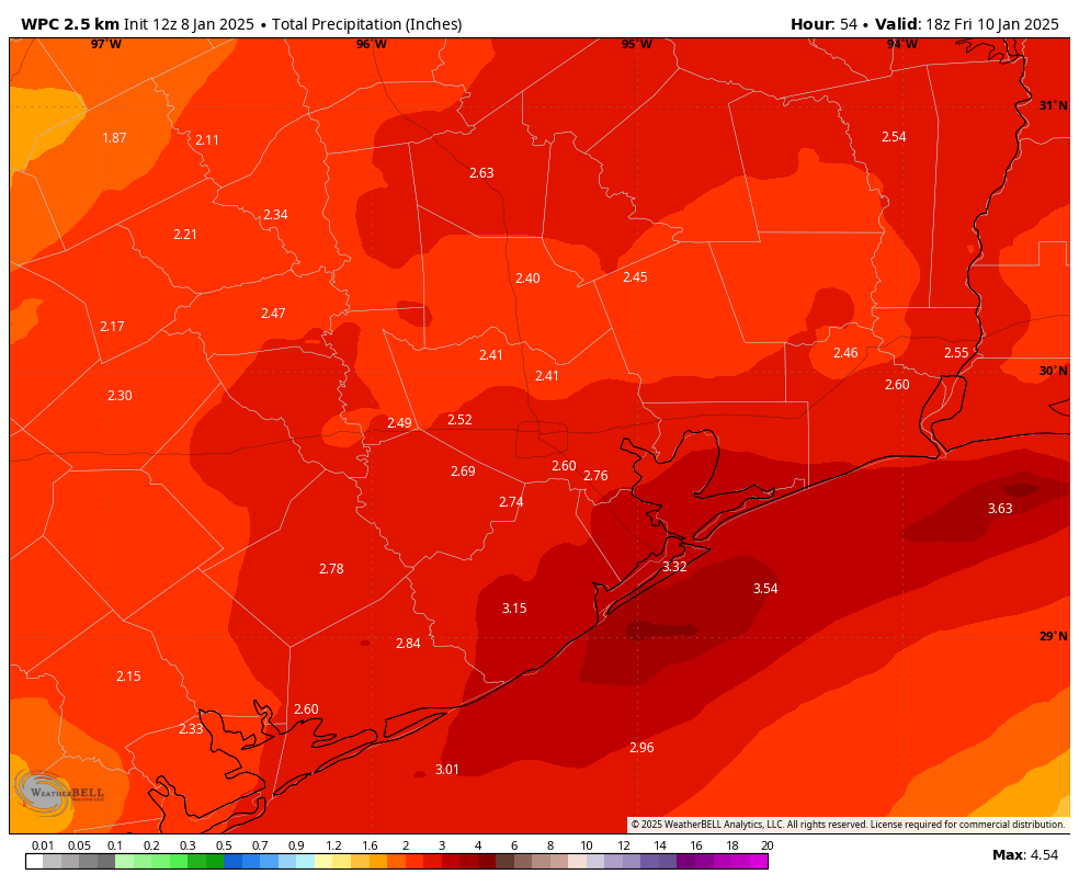
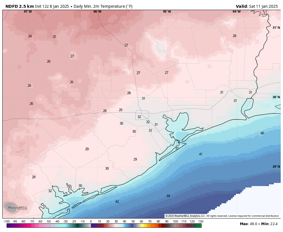
In brief: Houston is not done with the colder weather, but our low temperatures will now moderate slightly for the next couple of days. As a coastal low pressure system approaches we’ll see increased rain chances on Thursday, and the potential for heavy rainfall Thursday evening and during the overnight hours into Friday. Sunshine returns on Friday.
Wednesday
Temperatures, generally, are in the mid- to upper-30s across most of the Houston region this morning. This is due in part to increasing cloud cover, which will also limit high temperatures today to the lower 40s. It will still feel quite chilly outside, however, as winds from the north gust up to 20 mph. So although we’re done with freezing temperatures for a bit, the brisk conditions are not going away. Lows tonight will drop into the upper 30s again for much of the region.

Thursday, Thursday night, and Friday morning
By Thursday morning we’ll start to see the possibility of light showers developing across Houston, and this pattern will continue through much of the day. With high temperatures in the mid-40s (even warmer near the coast) there is no threat of freezing rain or sleet in the Houston area. It appears as though the main impulse of showers and storms, due to a low-pressure system in the Gulf of Mexico, will move in on Thursday night. The best chance for heavy rain will therefore occur during the overnight hours, and closer to the coast. Much of the area is likely to pick up 2 to 4 inches of rainfall, with higher isolated totals possible. This system should push east of the area by Friday morning, (mostly) bringing an end to rain chances before noon.
Friday
Another pulse of colder and drier air will push in as the coastal low exits, and Friday looks to be a breezy and cool day with mostly cloudy skies and temperatures in the 40s. With skies likely to start clearing out on Friday night, expect a chilly night, with parts of Houston likely seeing a light freeze again, and far inland areas possibly experiencing a hard freeze.

Saturday and Sunday
The weekend should bring mostly sunny and milder conditions back to Houston. Expect highs of around 50 degrees on Saturday. Lows on Saturday night should remain comfortably above freezing, with highs on Sunday possibly reaching as high as 60 degrees.
Next week
We’re not going to warm up much next week, with highs likely in the 50s and lows in the 40s. There’s still not a whole lot of clarity for the Houston Marathon forecast. I expect next Friday and Saturday to see a warming trend, but there’s a chance another front comes through by or before Sunday morning to cool things down. Of course a front could mean rain so yeah, the forecast remains uncertain.

It does not look like this month will challenge January, 1978 for the cold record but it’s looking like it will be well below normal.
During that frigid month the mercury dropped to freezing or below 17 times…
The Houston Marathon was on the 21st of January that year the low was 25 and the high was 31 with a trace of snow.
Ron Tabb and Peggy Kokernot were the winners that year with times of 2:17:15 and 3:01:54 respectively.
I don’t miss those 1970’s winters at all…
December 1989
Coldest temperature: 7° on 12/23
Nights at or below freezing: 14 over 2-3 weeks.It was so cold branches were snapping off and breaking powerlines! we didn’t care though we still went out dancing at Randy’s nightclub on Westheimer!
Is there an excited dog meter for the rain on Thursday night?
Yes, Bernice has one, and also that weird guy they call “The Claw.”
Is the weather on Thursday night going to be severe, like high winds/lightning/tornados? It has strong colors on the radar.
Definitely not tornados, as that require warm moist air that we will not have. Likely not lightning either.
While severe weather is not likely with the cold airmass in place, lightning can still happen anytime you have rising air and alot of moisture in the air. Now the frequency of lightning definitely goes up the warmer the air is because warm air holds alot more moisture, which is the primary source for lightning.
Absolutely. Those strong colors mean it’s gonna be crazy and destructive.
You can get tornadoes in the cold too Doomer. High and low pressure systems don’t mix.
I don’t think you can get tornadoes with dew points below 55 degrees. The type of instability needed for tornadic storms is not going to be present in our region this time. It will be too cold, and dewoints will be in the 30s and 40s, well below the threshold for severe weather. Supercell storms typically form off frontal boundaries separating a warm wet airmass from a cooler or dryer airmass.
It’s not common, but it can happen, even at colder temperature differentials. Let’s hope you’re right and it doesn’t. Especially with the recent stuff we’ve seen.
Mary, it’ll be safer to drive on the roads in north TX near Dallas. I’d advise going there Tomm. In fact sitting on the freeway would be advised. And wait for a 18 wheeler behind you to help push you ahead.
You need some serious help
On 12/28, Matt mentioned the under-predict of the severe outbreak. “Sometimes models have trouble catching up to anomalies […in Gulf temp…] this significant.”
Is the Gulf the same way now, and would that mean this rain may be far worse than predicted and risk a big flood?
Water temps have dropped significantly and are no where near as warm.
The heat in the water columns is running deep. Hundreds of feet deep in some parts of the Gulf. Don’t count on that being cooled down by surface temps. It’s on a trajectory.
Surface sea temperature anomalies have a direct effect on the weather. Lower water temps don’t play a role in the short term like with this particular system.
Water temps have not dropped significantly. Water absorbs and retains heat well.
The GOM temps are roughly the same right now as the end of December 2024, still almost 2° above the 1991 – 2020 average for this time of year, and more than half a degree warmer today than in this day last year. The so-called anomaly is heat-positive by at least 1.4°.
Wish it were otherwise. Lots of heat retention and fuel for the coming months.
According to NOAA water temps at the entrance to Galveston Bay are 12 degrees colder than they were during the Tornado outbreak in December.
You two are talking about somewhat different things. The entrance of Galveston Bay is shallow, so yeah it’s going to be a little cooler by default but doesn’t really matter here because it’s water further south driving the storm.
Even with the warmer Gulf temperatures the atmosphere won’t be unstable enough to create rainfall rates heavy enough to cause widespread flooding. When temperatures are in the 30s and 40s it is very hard to get widespread torrential rains. It will likely be a steady light to moderate rain with some heavy pockets. Plus the ground is still dry from the lack of rain we’ve had since the fall which means it will absorb alot of the rain that falls efficiently.
When the January temperature map came out, it showed the Houston area above normal. Ain’t lookin’ like it.
Well atleast we can still rely on January to bring us cold seasonal winter weather. 👍
Thank you always for your service to Houston.
Nothing worse than cold and rain. Bring on the warmth!
Am I seeing the european model correctly? Snow on January 22?
Respectfully, if you’re buying into precipitation forecasts 2 weeks out, especially Gulf Coast snow forecasts, you should probably not be looking at model runs.
No lie. In early December 2016, some of the models predicted snow in our area on Christmas. We ended up having highs in the 80s that year. Tim Heller, former chief meteorologist for channel 13, said that there are literally over 20 different computer models that will spit out all kinds of random things, and some meteorologists will advertise the most “clickbait” models two weeks in advance to keep people watching when they know that there is a high likelihood that these models are terribly wrong.
Lol. Gulf of America…