In brief: Heat and humidity will be a bit worse than usual for August this weekend, and although things ease up just a bit next week, we will remain hot and mostly dry. There may be a shift toward better rain chances next weekend.
Today through next week
Sunny, hot, humid. Highs in the mid-90s to near 100 degrees. Maybe a rain chance. And you know what? I congratulate my neighbors that have seen showers this week and may luckily see showers into the weekend too. Good for you, I say!
Why is this happening?
In all seriousness, we all know the forecast at this point, so I figured I’d take a moment to discuss the “why” today. It’s kind of fascinating. Last summer we saw a suppressed, strong ridge of high pressure over Mexico that would continuously flex over Texas. This kept us in the 100s daily and made last summer another level of terrible. This summer? Much different. Texas has been stuck generally between persistent areas of high pressure, one in the East, one in the West. To date, it’s been the hottest summer on record by a mile for Las Vegas and Phoenix. For Atlanta it’s the fourth hottest to date, and for Raleigh, NC it’s the third hottest. For Houston, it’s “only” been the 12th hottest summer and, even less impressive the 24th hottest for our frienemies in Dallas.
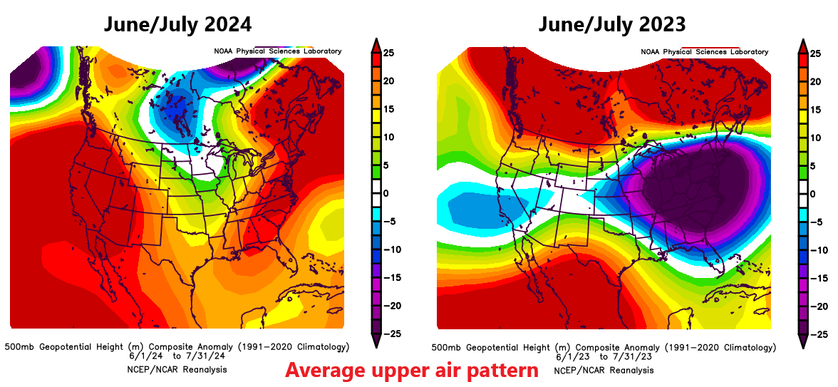
But so far this month, the pattern has changed allowing for the Western ridge to expand into Texas somewhat, which has in turn allowed us to crank the heat. Over the next five days, check out where the ridge of high pressure situates.
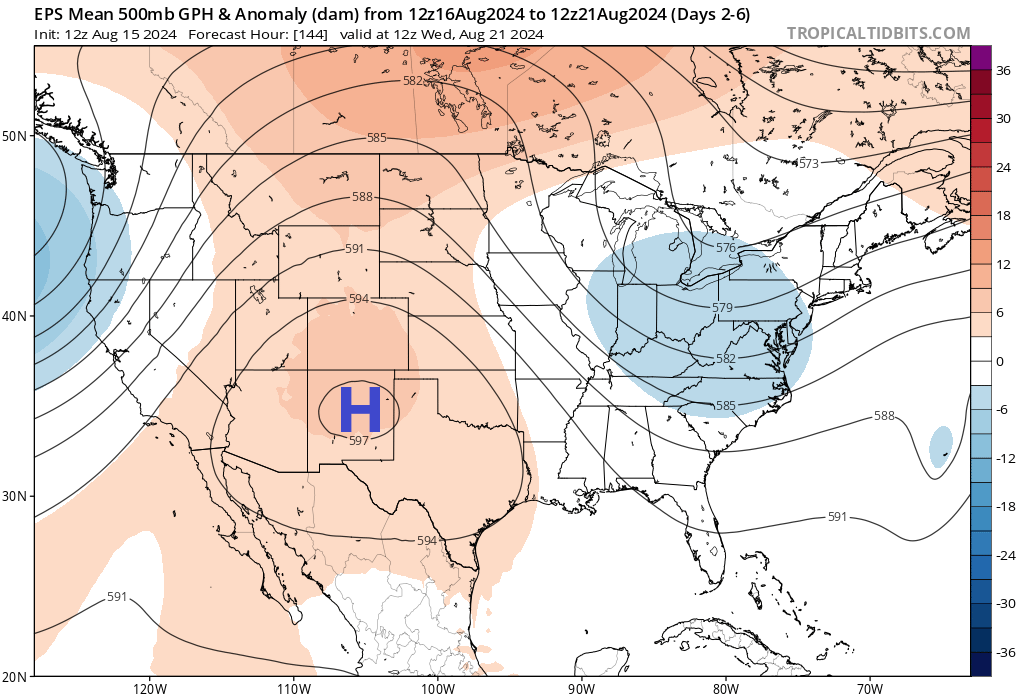
Over the next week it basically sets up shop just to our west, which will keep us firmly under the influence of heat. Unlike last summer, we aren’t directly underneath the high, so we will have some modest rain chances and it won’t be as extreme as was seen last year. But our weather will continue to be controlled by this feature. Odds of above normal temperatures and below normal precipitation will remain strong heading deep into next week. The next few days should be the worst of it for now. We may see a relaxation in this pattern later next week with the ridge retreating a little more to the west leading to slightly better rain chances toward next weekend.
Whatever the case, this coupled with a quiet tropical Atlantic over the next several days (outside of Ernesto) is not necessarily a bad thing for Houston. We’ll take it, but do take it easy with this weekend’s heat.

At least it’s 100 and not 109.
Amen to that! Last summer was awful. I’m glad this summer is being much more reasonable.
Anything 100 is still bad regardless if its not 109
*it’s
Thank you both for your avoidance of the inane “Heat Index”. The weatherscare industry spends more time with this than they do with the science. Keep up the good work.
Spike
Does solar maximum have any influence on our heat? https://www.space.com/solar-maximum-expected-2024-new-predictions-suggest
Here’s a question, maybe for one of your Q and A’s: why did last week’s high pressure correspond with almost zero cloud development and rain chances, while this week I’ve seen a lot more significant development (even if minimal rainfall still happens)?
Thank you for the good work as always.
My best guess is because last weeks high pressure was associated with dryer air and the winds were coming out of the north. This week our winds have shifted more out of the gulf which has put more moisture in the atmosphere. Even under high pressure the sea breeze can add enough lift to temporarily overcome the sinking air above and create scattered thunderstorms.
I’d like to point out our exceptional chance to open our pores this Saturday at 5-8AM. Surface wind will be low (~2mph), temperature will be moderate (~80 deg F), and the air will be almost completely saturated. If you are the type of person that likes their sweat to evaporate, then consider being outside Friday or Saturday around 5PM (~97 deg F, 7mph wind, 55% humidity).
Our frenemies in Dallas 😂
We are more alike than we are different. But, man, those differences…
A typical summer for us seems like a cool one when compared to last year. Only two days breaking the century mark seems well below our average up to this point. Hopefully Fall Day comes a little early this year…
Even though the air temperatures are alot cooler this summer the dew points have still been off the charts atleast in my area. Yesterday the dew point at the Angleton airport was 81 with an air temp of 93. That put the heat index at 114. It is not normal to have dew points so high in the afternoon hours. I’ve noticed that the past 2 years especially dew points are not dropping during the afternoons anymore like they used to. That is a direct consequence of a warming gulf. This is largely responsible for the warmer nights and higher heat index levels. I only expect this to get worse in the future but hopefully a long cold winter will help cool the waters down some. But actually getting a long cold winter is the trick.
A La Nina winter would trend against a cold winter on average. Well, that and the fact that we’re at 30N, so cold winters are somewhat anomalous anyhow.
I agree with this; doing yard work this year has been an order of magnitude worse than last year, the humidity is crazy
If a high pressure keeps it hot, but helps to steer any hurricanes away, bring it on!!
This.
This time of year I begin checking out temperatures in Siberia and northern North America/Greenland. The downward trend is well underway.
Yes I do the same thing and I have noticed that too.
Hello and good morning, I’m interested also in air quality for the weekend and following week. Us asthmatics seem to be having a hard time in this heat
One should never complain about being under the protection of a High Pressure ridge in the heart of hurricane season…
All this to say that it’s a typical August in Houston, just like most of the past 40ish years of my life. But, despite the fact that the forecast is very predictable and very usual right now, it’s nice to see the comparison.
Well, it’s actually 2.3 degrees above normal for the month of August so far at Bush Airport and 3.4 degrees above normal at Hobby Airport. If August ended today, it would go down as the 3rd hottest August on record for both Airports. So, it has not been quite typical in the city of Houston, but that can be partially attributed to the urban heat island effect. The coastal stations are reading barely half a degree above normal so far this August.
This is the 12th hottest summer ever? After last year, I was thinking this was a relatively cool summer😭. I hate this new normal. If this was 20 years ago, it would seem like a sweltering summer. But now we think of it as average!
(btw, this has nothing to do with complaining about houston and everything to do with global warming!)
I agree. I have done heavy research on the data and it is pretty clear that our summers have been getting worse and worse on average. The nights and days have been getting warmer than the 30-year average more frequently. We’ve always had our extreme heat episodes, but it was not near as frequent as what we are seeing today. I’ve mentioned several times on this site that the other symptom of a warming Earth that gets overlooked is the excess water vapor release from the oceans. This means higher dewpoints, which leads to higher heat index values and more days of dangerous wet bulb temperatures. We didn’t used to see so many days of 90+ degree wet bulb temperatures even during our hottest summers back then. We also didn’t used to see multiple heat advisories and excessive heat warnings every summer like we do now. The extra moisture in the air is making the summers feel worse and more dangerous to our bodies.
It doesn’t have to be 105 or 109 degrees for it to be dangerously hot outside. Air temperatures just in the low to mid-90s can be quite dangerous if the dew points are in the upper 70s and low 80s. That is what has happened a lot this summer. Remember most of us had a heat index of 115+ back on May 27th. That never happened in May before this year. Clearly, something is going on that isn’t normal. This Summer for us has definitely been better overall than last summer, but several Western states just saw their hottest July on record by far. You best believe we will likely see another summer like 2023, 2011,1980, or worse by 2030 with the current trend we are on.
The high pressure is good though. It is keeping hurricanes away. This summer has been quite a bit cooler than last summer.