In brief: More of the same is expected over the next few days in Houston, with cool-ish mornings and very warm afternoons, along with a good bit of sunshine. The weather pattern changes for a time next week toward humid with rain chances. Then, perhaps we can await our next front.
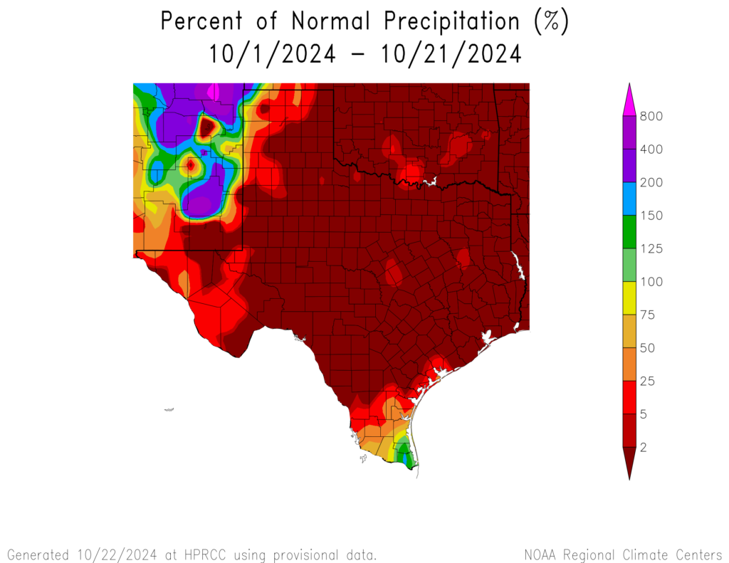
About 800 miles separate the two portions of Texas that have done well in the rain department this month: The mouth of the Rio Grande and the tippy top of the Panhandle. New Mexico has outperformed Texas, even with some serious flash flooding there recently.
But in general, we are far from alone right now in this dry pattern. The next couple weeks will bring us more of the same but also some potential for change, particularly next week. I think looking at the European ensemble for low temperatures the next two weeks shows how the pattern splits into 3 differing acts of weather.
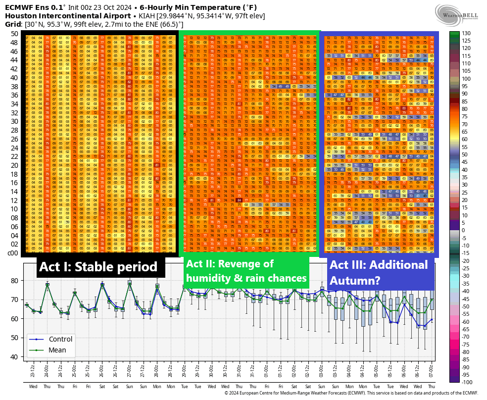
Act I: The stable period through Sunday
Over the next several days, things will be pretty calm. We can expect daytime highs in the upper-80s, just a couple degrees shy of daily records. But if you want some autumn flavor, the mornings will remain fairly cool, in the 60s. These temperatures are still solidly at least 8 to 10 degrees warmer than usual. Rain chances will remain nil. We will get a weak reinforcing shot of drier air Friday that should extend this weather through at least Sunday and possibly Monday.
Act II: Revenge of humidity and rain chances
Next week sees a change. We’ll have both more unsettled weather and increasing rain chances, as well as much more humidity. Overnight lows will likely shift into the low-70s, about 10 to 15 degrees warmer than normal, while daytime highs will hold steady or even fall a few degrees due to clouds and rain chances.
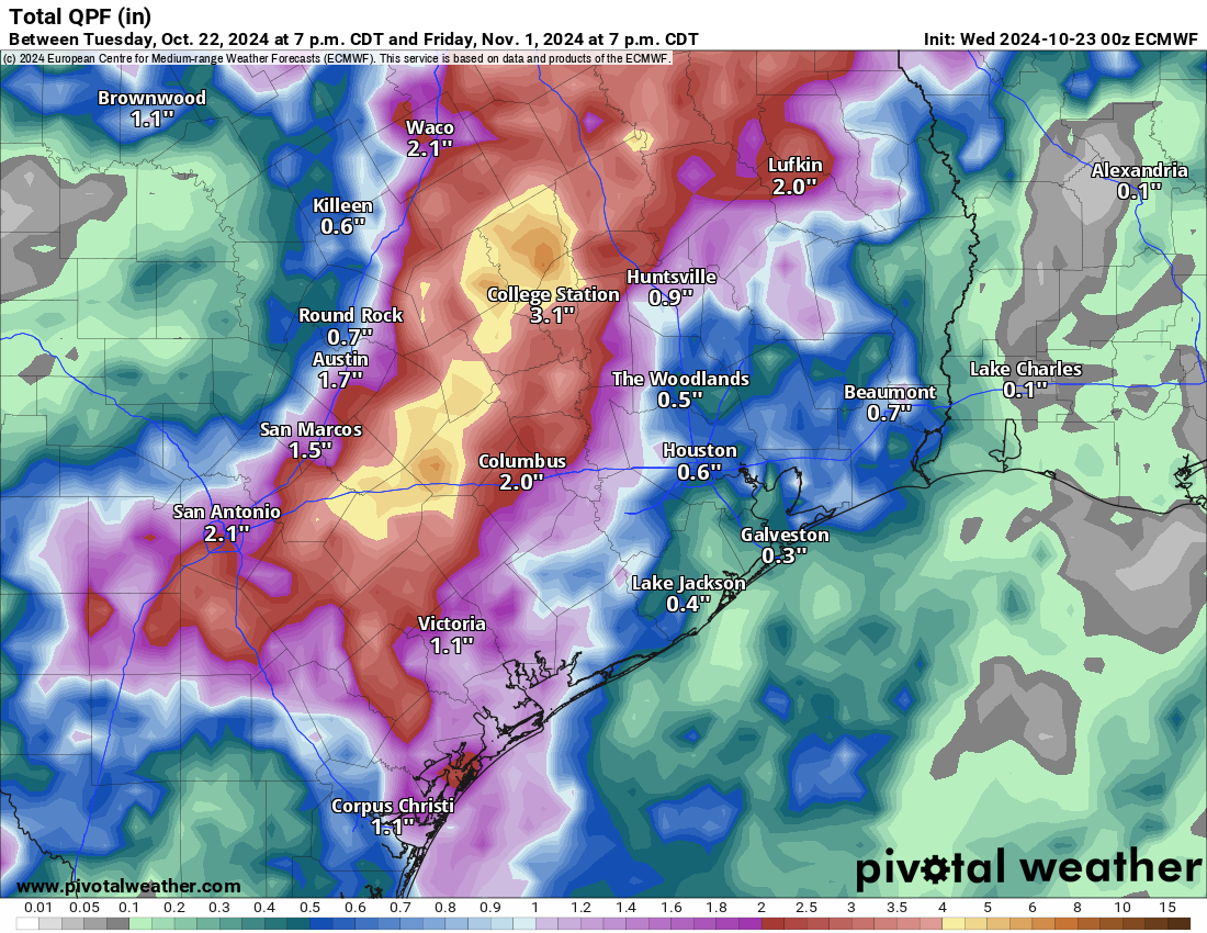
I think we want to be realistic about rain chances next week. In a drought, sometimes you find ways to fail, and while I would still expect at least an inch or so of rainfall from scattered thunderstorms next week, the heavier rains, the 2 to 4 or 5 inch totals will probably be confined to a narrow corridor somewhere in the area along or northwest of highway 59. Something we will continue to watch. The European operational model shows this well below as a possible example of what could occur.
Regardless, we will see just a warm, humid, un-autumn-like week next week.
What this means for Halloween remains partially unclear. There will almost certainly be a chance of rain, but it will almost certainly also be warm. So plan for warm right now, but check back with us on the rain chances which may not become clear until early next week.
Act III: Additional autumn?
After next week’s pattern shift, we could see a return to something more typical for autumn. I would say there’s probably a 40 to 50 percent chance of a meaningful cold front around next weekend. The exact timing is uncertain, but there’s enough signal in the models for us to think there’s a decent chance. We’ll keep watching.

Ok, so the only certain thing is that we are flirting with daily hot records and no rain the next few days. The rest of your forecast is fuzzy. Got it.
I prefer this type of writing vs the long drawn out fuzziness. Short and simple.
Ugh. Is this going to be another one of those mid-80s and humid Thanksgivings and Christmases?
In my, admittedly, short 13 years here, both of those have been warm and humid more often than not. Miserable for the holidays.
this is Houston…
Most likely
holidays are either humid, or rainy, temps can be maybe cold, but more likely not hot.
I’ll take warm and humid all day.
“Revenge of humidity” is not something that I ever want to hear, but if that’s what it takes to get some rain, so be it.
More humidity at the end of October? Fantastic! 🫠🥴
On the bright side it’ll be nice for this weekends Wings Over Houston Airshow 🙂
88-90 is pretty crappy for the airshow tbh. Hopefully that shot of dry air with a weak front Friday keeps it manageable. I was so happy with another late October airshow date but this year isn’t working out well. Surrounded by pavement and not a cloud in the sky to shield the sun. Its gonna be hot. Ill be prepared with sunscreen and lots of water for my son and I. Still looking forward to it.
The mornings will start out cool. The dry air should make it a bit more comfortable. I’d suggest a small umbrella / sunshade and foldable camp chairs. Absolutely bring lots of water. I’m not sure where I’m going to be stationed, but I expect to have some access to shade. I’m not going to be a rover this year 🙂
Please define your description(s) of your weather projection models. Example: “European Model”. It may be great to opine about your references, but to us unweathermen it’s all Greek & Pig Latin
Thanks
Do a (Google) search for:
“European Model” weather
… and be sure to include the quotes – you will see countless articles describing it and the GFS, plus a few that compare the two.
But in brief:
The European Center for Medium-Range Weather Forecasts (ECMWF) model is a medium-range weather prediction tool used in Europe. It gathers data from satellites, ground-based weather observations, and other meteorological sources to create numerical weather predictions.
.
Many US oriented meteorologists use both models to create their forecast.
If it’s going to rain make it happen on the 31st. I hate Halloween, bunches of kids prowling the neighborhoods and banging on doors looking for free stuff; I can’t imagine what message that gives.
It is yet another one of those Merchant promoted activities to boost their sales of candies.
What is the Grinch equivalent for halloween? “Ken”. The message it gives to me is loving community. Who knew seeing your neighbors, and putting smiles on their childrens faces would be such a nuisance. Just turn your porch light off and put a note over the doorbell.
The ‘neighbors’ in my community are all from the local apartment blocks and arrive with masses of cars filling the streets. But thanks anyway for your thoughtful – if impolite – response.
Around here, there are kids out trick or treating before many people even get home from work. At least let people have a chance to get home and relax a bbit before accosting them for treats.
I bet you are fun at parties.
I wonder why it is when a person states their opinion, others come out and make negative comments about that person. One could just as easily – and merely – say that they like the subject in question (in this case Halloween).
I suppose it’s all because of the ‘anti- social media’ that is slowly destroying our society.
But it’s Halloween!
🍂🍂🧡🍂🍂
🍂🧡🧡🧡🍂
🍂🍂🧡🍂🍂
🍂🎃🍂
How can you not LLLL🎃VVVEEEE Halloween? It loves you!
👻 <– (ghost hug for KenJ)
Ashley used “kill them with kindness” – its super effective!
Many folks are absolutely clueless about the origin. In today’s culture, the day has become a celebration of horror, being associated with the macabre and supernatural. Ask the average citizen what the origin is and they’ll get it rwong.
And I agree a bit with “Ken J” … not everyone wants to participate. The respondents are clueless.
We’re in acreage country … absolutely zero kids and family want to walk 100 yards from the street to porch for the 20 properties around us. And most all are fenced off. That’s the best solution – get away from the big city – and for many other great reasons!! 🙂 )
I hate to say it, but I agree with Ken to an extent. I don’t want to buy a bunch of candy I can’t eat and will have to throw away. I don’t want to give out treats that set up kids for sugar addiction as teens and adults. And to avoid having to answer the door every five minutes, I’ll have stay in the gym until about 9 PM. At least that would be healthy.
Based on a longterm forcast I saw, we probably won’t get a cold front here again until November 5th or 6th.