In brief: In the main, our hot and sunny weather will continue through the rest of the work week. We have no weather concerns for the Fourth of July, aside from heat. Our overall pattern may change this weekend, with slightly cooler temperatures and increasing rain chances due to moisture from Hurricane Beryl.
Fourth of July forecast
The forecast for the forthcoming holiday, on Thursday, is straightforward. High pressure should be firmly in control of our weather, and this will lead to a hot and sunny day. High temperatures on Thursday will hit the upper 90s for much of the city, with coastal areas remaining in the lower 90s. Winds will be light, from the south, at 5 to 10 mph.
Temperatures at the time of fireworks, about 9 pm for most locations, will be in the upper 80s, with partly to mostly clear skies. There is only about a 10 percent chance of rainfall during the daytime, so there should be no concerns on that score. However, our ‘excitable dogs’ scale will be a 10 out of 10 given that most of our canine friends do not enjoy fireworks. Enjoy the holiday, everyone!

Tuesday
Today, like much of our recent weather, will be mostly sunny and hot. Most of the city will reach the upper 90s, with light winds. There remains plenty of moisture in the atmosphere, but high pressure (which promotes sinking air, rather than the rising air conducive to showers) will keep a lid on activity for the most part. Expect only perhaps a 10 percent chance of rain this afternoon and evening. Lows tonight will only drop to around 80 degrees for most locations.
Wednesday
Temperatures will be warm again on Wednesday, although we might be a few degrees cooler. In addition, we may see a few showers streaming in from the coast, so I’m going to bump rain chances up to about 20 percent. As for humidity, well, do you have to ask about humidity in Houston in July?
Thursday and Friday
The end of the week will see more hot and sunny weather. We’re taking temperatures in the mid- to upper 90s, with lots of sunshine and only low-end rain chances.
Saturday and beyond
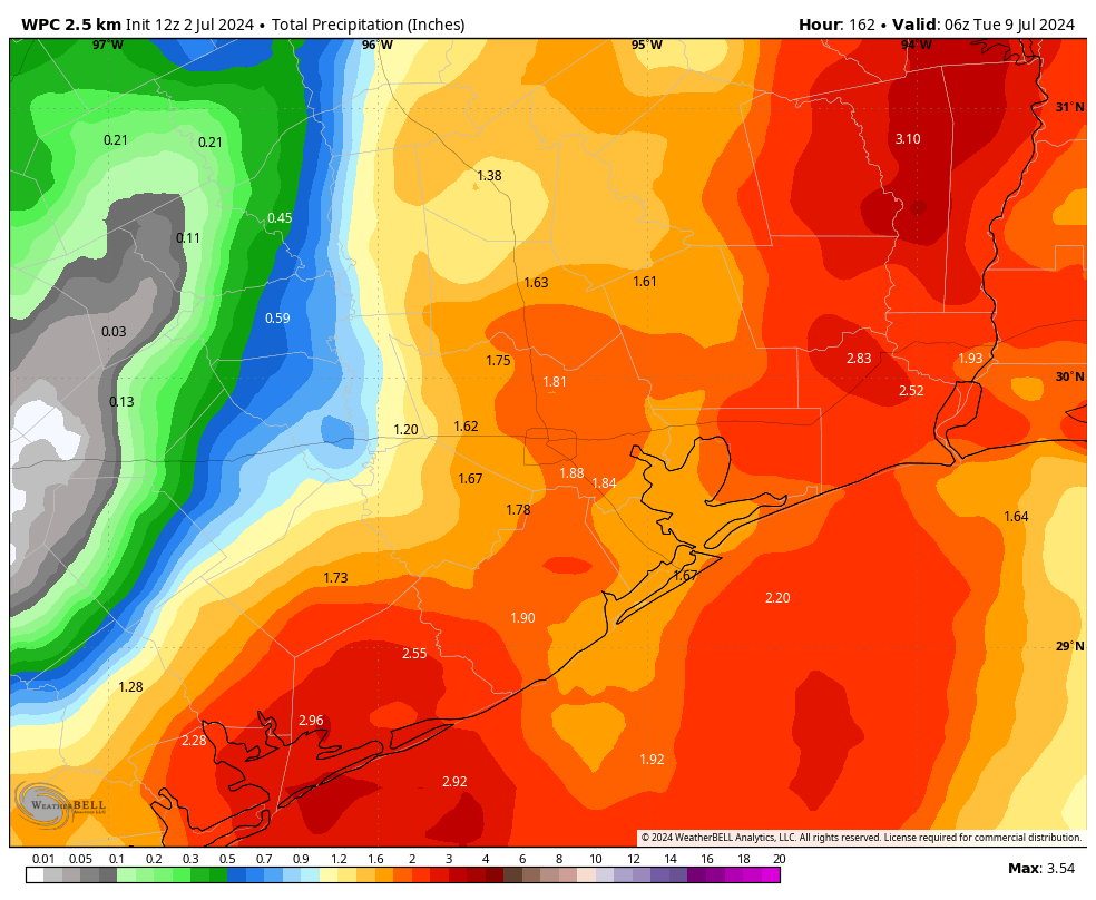
Our overall pattern may begin to change on Saturday as high pressure begins to back off a little bit. Our temperatures should come down a few degrees, and rain chances increase. The changes will be modest, but by later this weekend our high temperatures should drop into the lower 90s, with daily rain chances increasing to perhaps 40 or 50 percent. This may persist into next week, depending on what happens with Hurricane Beryl and its moisture.
Hurricane Beryl
As it moved into the Caribbean Sea on Monday, Beryl had an astonishing burst of intensity for early July, reaching Category 5 status. There is fairly high confidence in the forecast between now and Friday, when the storm will likely move into the Yucatan Peninsula. A weakened Beryl will then move into the southern Gulf of Mexico.
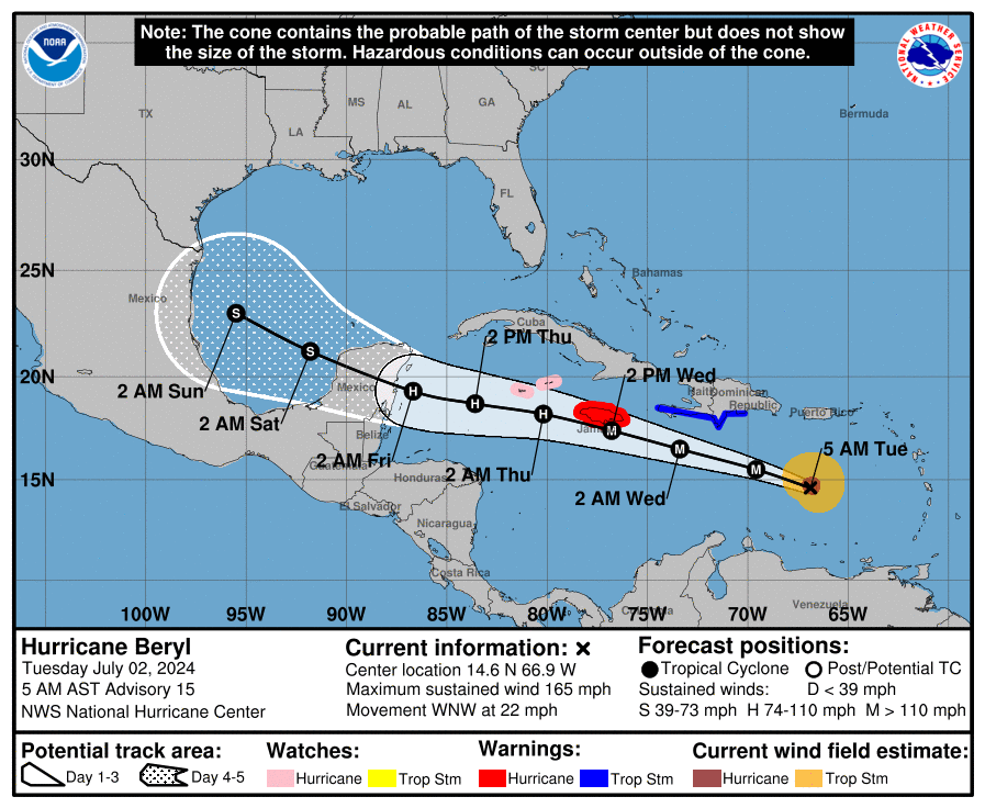
After that time the system will most likely remain bottled up in the southern Gulf of Mexico. However, given the trend toward weakening high pressure over Texas, some of the the moisture from Beryl could work its way north. This will influence the extent to which Houston sees increased rainfall chances late in the weekend and next week. Is there a scenario in which Beryl becomes a bit more organized and its center tracks toward Texas? Yes. But for now this seems less likely an outcome than just increased rainfall chances for the greater Houston area. We’ll keep a close eye on it all.
For more on Beryl, be sure and check out our detailed forecasts on The Eyewall.
A message from Reliant
Thanks to Eric and Matt for the hot and sunny July 4th forecast!
Throughout the peak summer travel season, many people often wonder what is best practice for cooling
an empty house – and if it’s even worth it. And for those staying home, staying comfortable while
hanging out around the house doesn’t have to run up the electric bill. Check out these energy efficiency
tips from Reliant to stay cool and save money, regardless of your plans for the holiday weekend!
Traveling for the 4th:
- Follow the 4×4 principle. Setting your thermostat four degrees higher than your typical temperature when you’re away from home for more than four hours can help reduce electricity usage. Keep in mind, every degree of cooling below 78 degrees increases your energy use by 6-8%. If you’re gone for days on end, it is not recommended to turn off your AC entirely as that can increase humidity in the home, stress your appliances and cause your system to work overtime to cool your home when you return.
- Close blinds, curtains or shades before you leave to reduce solar heat gain by up to 30 percent.
- Replace the AC filter before taking off – a clean air filter can keep your A/C running at peak condition.
Enjoying the holiday from home (in addition to the above):
- Rotate your ceiling fan counterclockwise for a wind chill effect. This can make the temperature in a room feel up to four degrees cooler, allowing you to be more comfortable and adjust your thermostat to save money. Don’t forget to turn off your fan when leaving the room.
- Avoid using heat-producing appliances like the clothes dryer, dishwasher or oven during the hottest times of day. These appliances can cause your A/C to work harder to keep your home cool.
- Install a pool pump timer to run early morning or overnight and clean pool filters regularly.
- Switch out old light bulbs for new LEDs, which use 50 percent less electricity, reduce heat emitted and last at least 10 times longer than traditional incandescent bulbs.

First
Hah
Thanks for the update
We have officially hit 100 degrees yesterday at Bush Airport, last happening on September 8th, 2023. Hobby Airport fell 1 degree short of the century mark, although chances are most definitely not over yet!
Yep. One down 45 more to go.
I am glad “we are not concerned about Beryl here in Texas”.
Keep calm and carry on.
I am. It could easily track north and goes as far up the coast as Louisiana. Fortunately, the most recent GFS and Euro models don’t show this, but others do.
SCW just said yesterday that they are not concerned about any TX impact. I’d trust them over some rogue model runs for sure.
Always those who like to stir the pot 🙂
I’m hoping Beryl will throw us some clouds (with no rain) as a parting gift.
If it will knock off a few degrees, every little bit helps.
I’m definitely hoping for some rain, my lawn is already getting crunchy and dry.
Great info from Reliant. Much appreciated.
Thank you for keeping us informed.
The track has shifted north quite a bit since yesterday and there still seems to be some uncertainty regarding the timing of this ridge of high pressure, plus we’d be on the bad side of it. But reading this post makes it seem like it’s headed to China. You guys are really taking the no hype to heart.
Reread their carefully measured words..They are wonderful weather people, but they just don’t know yet..It seems we don’t get really solid high confidence information from anybody in the media, to make plans on, until about 48 hours out from a hurricane..I’m not a wealthy person who has a second home somewhere north of Texas to trot to..I would have to compete with a gazillion other people to make hotel reservations, and pack up to move to that hotel, and fight ungodly horrendous traffic of historic proportions to get there…For those who usually want to leave before the storm hits, this increasingly narrow time window of warning given to us over the years, is frustrating…This is the life of somebody who chooses to live fairly near the coast in a hurricane prone area..I have the feeling, I may decide to sell my property and move 3 or 4 hours inland..I enjoy my summers, but I am beginning to feel like I don’t want to have to keep a very close eye on hurricanes weekly/every two weekly for 6 months out of the year..
Your comments are valid regarding living near the coast during hurricane season, but living in fear is not healthy and if the best solution is moving away from the coast then do so if possible
I enjoy living here..The best thing is to have a very solid evacuation plan..Like family who lives north and would love to have us for a few days or weeks..Or have a second home up north..Having to make room reservations is a bunch of hooey, especially if this hurricane season has us doing so once or twice a month..Having a forcast that allows evacuees some time to move without threat of being on the road as the storms hit is crucial..We’re older, and we prefer not to ride out a hurricane and live without food and electricity for weeks…The current forecast makes us feel silly to even begin to have plans to leave dodge..But at 2 days out, when forcast is more certain, roads are already crazy, and reservations are in non existence, unless one wants to book a room or b and b in TN..I’m more pragmatic than fearful..
I’m with you. Lived every day of life right here in Houston, but I have had enough. After the storm in May I can’t just do it anymore. And the May storm wasn’t even a hurricane.
I’ve already started the process of selling my house and searching for the best place to go. I’m basically just too old for this kind of crap.
Yes, it’s too stressful with the rising heat, severe storms, hurricanes, increase in property taxes, etc. I begged for a transfer at work and it was approved. We are also moving soon. This will be my last hurricane season. Life these days has enough stress as it is without adding this constant nonsense weather on top of it.
Reliant’s recommendation to turn off fans when you leave the room needs more attention. Much like a tree falling in the forest only makes noise if there is someone there to hear it, a fan only cools if there is someone there to feel it. Fans use electricity and, since they’re not perfectly efficient, some of that electricity is wasted as heat. In a perfectly sealed room, a fan would actually heat it up (energy added to the sealed room). This has been today’s Thermodynamics 101 lesson.
The astonishing power and sudden explosiveness of Beryl – especially so early in the year – should scare the daylight out of anyone living on or near the gulf. Houston may escape this one but the unprecedented heat of gulf waters portends great danger in the near future. It’s a question of when, not if, a cataclysmic storm hits our city.
Well, friends, this is just the start! This cr*p will be going on all summer, and into fall as well! Only maybe 15-20 more storms to go! Don’t you just love living on the Gulf Coast?
I do. People just need to chill out and realize that there is always some danger in life. I certainly prefer something that one is warned about days in advance than something that can happen with almost no warning like earthquakes or wildfires or tornadoes.
Or a dericho – which is the most frightening, no warning thing I have ever seen living on the upper GC for 25 years. And those can happen up north too.
Frightening and no warning? Try a good Midwestern tornado. I saw the one that destroyed Xenia many years ago. Very scary and it wasn’t even headed my way.
Thanks for the detailed and hype-free (fact based) forecasting.
I do have a message for Reliant as well.
I do not want to shop for electricity plans while at the grocery store or an Astros game. I will never purchase electricity from Reliant out of shear principal because of their annoying ambush sales tactics. “Can I ask you who you use for electricity?”
I did mark my calendar that the >90 day drought began June 27 and we can soon begin counting 100s – using Hobby station.
This pattern has become the new normal (for 5 summers anyway) and was earlier for the “urban core” than last year. However it does appear the “dome” will exit temporarily on Sunday while the storm is in the GOM. Very interesting.
At 2-3 cpg for rather chlorinated and high alkaline city water I prefer not to irrigate. Not good for the flora … so happy about that. We’ll see.
But no Beryl update on The Eyewall yet today…
Most of the time I love your forecasting..What I am reading in other weather outlets today, is that there is a non zero chance that Beryl could hit Houston, but the chances are low..So at the moment I’m still proceeding with plans to spend the weekend swimming with my granddaughter, vs making plans to get the H out of dodge..
I am frustrated because I have noticed hurricane forecasting seems to have changed for the worse..Now these storms are about 48 hours from our doorsteps before officials can even hint that the storms are coming our way..So it sounds like we won’t know with a good level of certainty, till Late Thurs or Friday, whether this storm will impact us with more than messy amounts of rain..
I live fairly near the coast, about 40-45 minutes away..Should I be concerned enough to cancel weekend plans with my granddaughter, so that I can make plans for a week stay somewhere more inland, like Austin?
This thing went from TD to cat 3 in 42 hours. IF, it were to do the same as it exits the Yucatan this would potentially have major impacts to its projected path. RI is not something the models handle very well and, thusly, changes to forecast paths have to be made appropriately. You can’t forecast a drastic northward curve to the path without sufficient information to warrant doing so.
So what we’re saying is that nobody knows, till the storm is right on our doorsteps..That’s exactly why I’m venting my frustration, lol..I either need to buy a second home north of Texas to escape to, or plan a long getaway that takes me away from the Upper Texas Coast during the WORST of Hurricane season lol…I’m not wealthy enough, nor do I have any family scattered about who is able to take me in during these storms…I never dreamed the weather coming off Africa, to cross the Atlantic would begin as early as late June 🙁
We moved to DFW a couple years ago and love it. Not all that different than Houston (as much as some folks make it out to be) and when there is a hurricane that impacts TX gulf coast, it’s just a light wind and rain event for us. Highly recommend if you can make the move!
Good for you. You get tornadoes and hail. We get hurricanes.
The problem with Dallas it is in the middle of nowhere, at least Houston is on the edge of somewhere. Anyway, neither town is preferable to somewhere else nicer. Maybe the south of France – that is if I can convince the locals to learn English before I get there.!
Dallas has flash flood and tornado
It’s looking worse for our entire coastline as of this model run..I wish the weather people would start sounding some kind of alarm, because our time to calmly prepare is shrinking…
I mean if the weather people know that we have more than a 5 or 10 percent chance chance of being hit..
Nobody is stopping you from preparing.
I know, I know…I’m sorry to vent out my frustrations publicly, and on my favorite two weather men…I’m just freaked out that this Atlantic hurricane train is happening so early in the year, early July….My husband and I, as old mildly disabled people with chronic pain, move more slowly than we used to..We find it difficult to prepare, whether we’re staying to ride out the storm or evacuating..
In spite of our difficulties and frustrations with living in a hurricane prone area, I would not want to move away from my little town (not far from Houston) unless I was moving to be nearer to my kids or sister..I love the people here..
Forecast service we use at work has it making landfall in Brownsville as a Cat 1 now.
Then why are you here ?? hang out at the “Forecast service we use at work”