In brief: In this afternoon update we talk about how the Arctic air may be arriving a little later than expected, and what that means for potentially icy roads this weekend.
Setting some expectations
Good afternoon. We are going to continue with twice-daily updates this week due to the interest in, and potential severity of, a winter storm this weekend. Before getting to that, however, I just want to note the nice amount of rainfall that fell over much of the region today. Most locations received 0.5 to 1.0 inch of rain, which was above expectations. Although this won’t spell the end of our region’s drought, a little bit of rainfall goes a long way in January. And as you may have heard, we have more precipitation on the way this weekend.
I also want to take a moment to set expectations. There has been some talk comparing the upcoming Arctic blast to the extremely cold winter storm in February 2021. I just want to say we are not anticipating temperatures nearly that cold (if you recall, low temperatures across the region in 2021 ranged from about 5 to 15 degrees Fahrenheit). Nor is the cold expected to last as long. Although this winter storm has the potential to be impactful, it will be of shorter duration. So yes, we should all be prepared for inconveniences, but I don’t expect total bedlam this time around.
You have questions about electricity and travel. We don’t have all the answers. What I can tell you is that ERCOT expects to have ample power generation during the coldest weather on Sunday and Monday. Locally, in terms of transmission, CenterPoint says it is well prepared to respond to outages, and is testing and hardening equipment. Hopefully that is the case. With regard to travel, we don’t know much more. In terms of flights, I think getting into and out of Houston airports will be fine on Friday and Saturday, but we do have some concerns about Sunday and Monday. We’ll see.
When is this mess getting here?
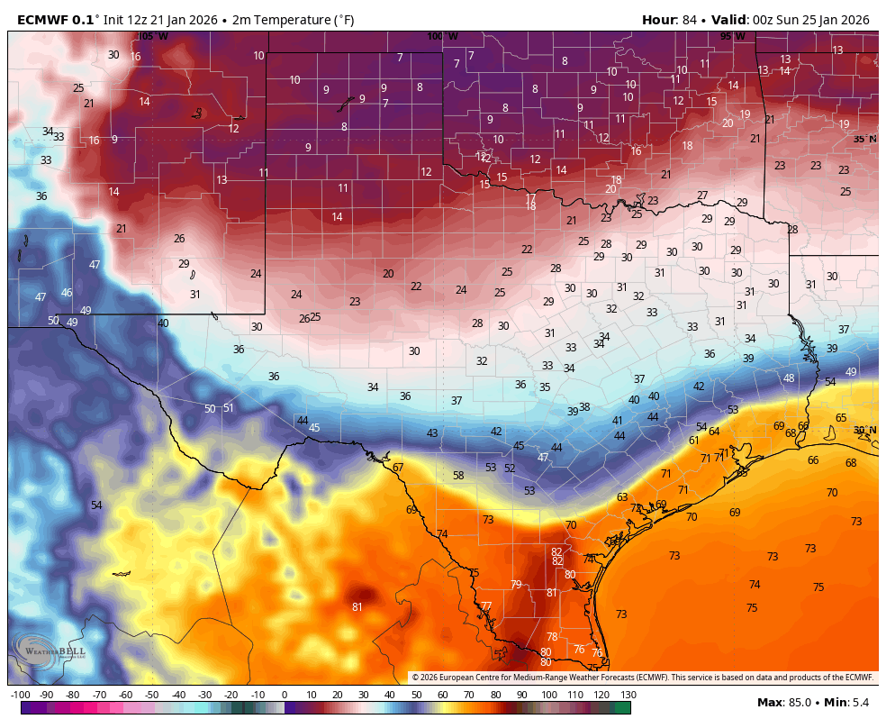
The one trend we’ve observed over the last day or so is a delay in the arrival of really cold air in Houston. With the caveat that all of this could still change, I now think we will see temperatures well above freezing in Houston (and surrounding counties) for much of Saturday. I would go so far as to say, tentatively, that it should be fine to move around the region through at least 9 pm CT on Saturday, and possibly a little later.
We are probably looking at plenty of rain on Saturday, but with temperatures at least in the 40s (or warmer), it will just be rain. However by later on Saturday night, and into Sunday morning, my expectation is that temperatures will begin to freeze. This will occur initially north of Houston, in Montgomery County, and then spread south into the city and down toward the coast.
Is there going to be freezing rain in Houston?
We still don’t have answers to this question yet. There is a chance that, with the somewhat slower arrival of the coldest air, the precipitation will have exited to the east by the time freezing temperatures arrive in Houston. That is one scenario. Another is that temperatures plunge after midnight, with rain showers persisting into Sunday morning. In this case we would see freezing rain accumulations on area roadways on Sunday. Right now I don’t have high confidence in either scenario. However, I think we need to be wary of the fact that, regardless of when the rain ends, there will be moisture on roads after the rains on Saturday, and this could freeze rapidly. Bottom line: The roads on Sunday morning could be pretty messy. We cannot yet say for sure what will happen. We will probably have a better idea tomorrow.
How cold is it going to get?
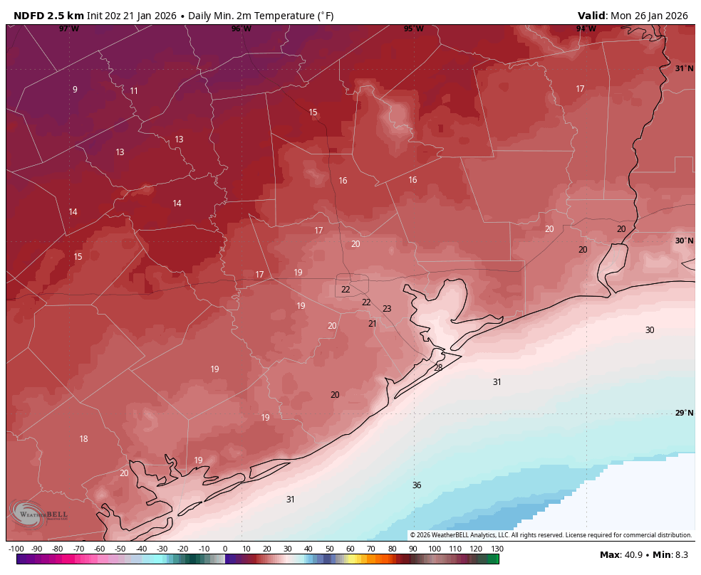
Despite the delayed onset of cold air, it unfortunately is still on the way. It now appears that Sunday, Monday, and Tuesday mornings will all bring the potential for a hard freeze. I think the coldest night will be Sunday night into Monday morning, when temperatures could drop into the upper teens in parts of Houston, and lower 20s closer to the coast. This hard freeze will necessitate care for outdoor plants, pipes, and of course pets. Please bring them inside on these extremely cold nights.
Really, Eric, do you think Houston is going to shut down due to ice?
I honestly don’t know. I want to emphasize that. But I will share what I am thinking at this moment.
I spoke above about different scenarios. The European model, of late, has been most aggressive about delaying the onset of colder temperatures. It effectively has the rain out of here by around sunrise on Sunday, and then has high temperatures getting into the upper 30s for most of the region on Sunday afternoon. In this case I’m reasonably confident that roads would be mostly dry for the hard freeze on Sunday night. In such a world it would be extremely cold, but the roads are mostly OK to drive on for most, if not all of the weekend and early next week. (The story, of course, should be vastly different north of Houston, toward Dallas; and west, toward Austin). There is also a world in which the colder air arrives earlier, before the rain departs, and we get a few tenths of an inch of ice on Houston’s roads. Then Sunday’s highs remain near freezing, and we remain ice-bound until the middle of the day on Monday. I really don’t know what will happen, but when we know more, we certainly will share that.
Our next update will be posted by 7 am CT on Thursday.
