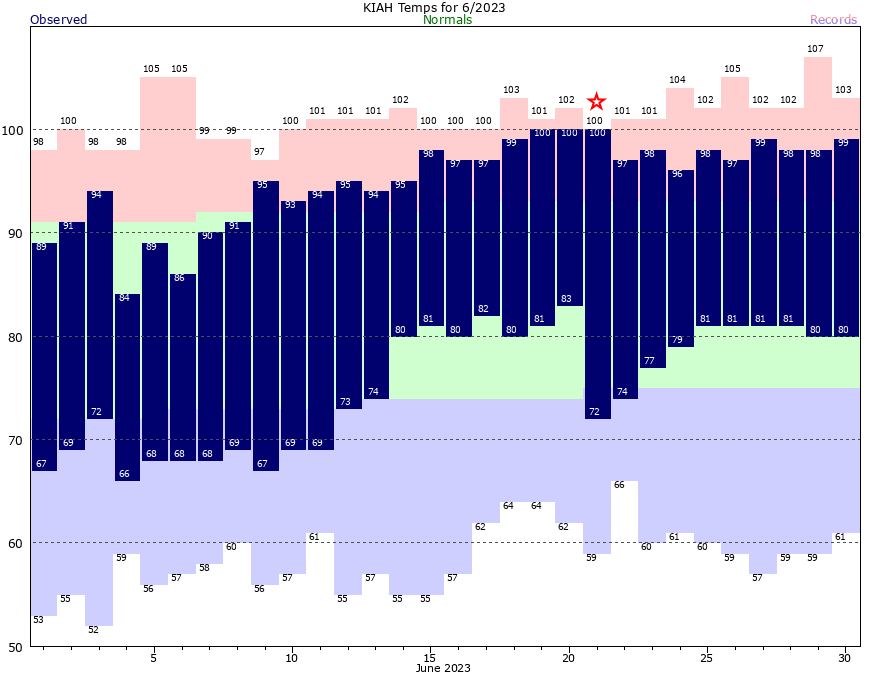
Before looking ahead to our weather in the days ahead, let’s briefly look back at June. The first 10 days of the month were relatively cool, with below normal temperatures and plenty of rainfall. Then our pattern dramatically shifted for the latter two thirds of the month, with highs generally in the upper 90s to 100 degrees, and extremely uncomfortable weather. Overall, with an average temperature of 85.1 degrees, this June tied 1980 for the sixth warmest of all time in Houston.

As we saw on Sunday afternoon and evening, the high pressure that dominated much of the last three weeks of our weather in June has moved off, allowing for slightly cooler weather and healthy rain chances. This pattern will persist for most of this week before high pressure starts to assert control again by next weekend.
Monday
High temperatures today will be about 95 degrees, which is hot, but not as hot as we’ve been. Skies will be partly sunny later this afternoon, with a mix of clouds and sunshine. Rain chances are probably about 40 percent, with the majority of showers developing near the coast this afternoon and then migrating inland. As we saw on Sunday, some thunderstorms are possible. Winds will be generally light, out of the south or southeast, at about 10 mph. Lows tonight will drop to around 80 degrees, or just below.
Tuesday
Conditions will be more or less the same for the Fourth of July, albeit with slightly better shower coverage. Let’s call it a 50 percent chance of rain. Fortunately, it does appear as though most of these showers will be diurnal in nature, assisted by daytime heating. This means that by the evening hours, and particularly after sunset, the majority of rain should be ending. This should allow for fireworks to proceed in most locations.
Wednesday and Thursday
Rain chances will peak during the middle of the week as low pressure and tropical moisture seep into the region from the Gulf of Mexico. A majority of the area should see showers and thunderstorms on these days, with accumulations generally averaging from 0.5 to 1.5 inches, although there will be plenty of outliers. Partly cloudy skies and rain-cooled air should moderate temperatures, keeping them in the low-90s for most of the area.
Friday
At some point the rain party is going to end, and that may happen as soon as Friday. Expect a partly sunny day with perhaps a 50 percent chance of showers. Highs will be in the mid-90s.

Saturday and Sunday
High pressure will start to build this weekend, and this should lead to a pair of mostly sunny days with highs in the mid- to upper-90s. Rain chances don’t look to be zero, but they’re probably not above 20 percent for both days. It’s going to depend on how quickly the high pressure builds over the area.
Next week
The majority of next week looks fairly hot as high pressure reigns, and should peak by Wednesday or Thursday. Heat advisories are likely to be necessary once again. Rain chances look accordingly low for much of the week.


So is next week the start of a “new” and even hotter heat dome or is it just a week of (what looks to be) super hot weather. Up in College Station they are predicting 106 for mid-next week and that just sounds insane.
What seemed unusual was very warm/hot air coming hard off the Gulf, it wasn’t that temps were so high, but temps at high humidity.
I don’t remember Sugar Land seeing a heat index north of 120 before.
Doesn’t a sea breeze usually moderate temps?
Last week I walked along the Seawall in Galveston starting in the early afternoon. One day Galveston was 7° Fahrenheit cooler than around Memorial Park. Although there was hardly any shade at all, the constant sea breezes off the Gulf made walking more tolerable than in Memorial Park.
Also I think Eric recommended putting on sunscreen. I began again putting sunscreen lotion on the head, arms and legs. I sat in the car for at least 10 minutes to let the lotion soak into the skin. The sunscreen seemed to really help on the mid afternoon Galveston walks.
You needed Eric to tell you to put on sunscreen for summer weather? That should be a common sense thing to protect your skin from sun. cmon stranger
The gulf is really warm.
I had to look it up…
di·ur·nal
adjective
1.
of or during the day.
Similar:
active during the day
nonnocturnal
daytime
2.
daily; of each day.
“diurnal rhythms”
I will be more than happy to have a long downpour on the night of the Fourth so that the ingrates who let off fireworks near our neighborhood and send my dogs into a panic are rained out.
Why do you hate freedom, Ken?
Complete the following sentence- “If you are depending on July weather in Houston to give you relief from a heat wave, you are super _____ “
optimistic
Too see a week of healthy rain chances in the forecast makes me so happy. I think of the native plants, trees, and wild animals also having to cope with a difficult Texas summer. Not to mention the Texas farmers and ranchers! I just wish there was a way to predict how long a heat dome (high pressure heat event) would last. I still call to mind the summers of 1980 & 2011. I was here both of those summers. Endless patterns of heat and drought with massive heat domes both years that would not budge until Autumn cold fronts. I hope we can have short cycle heat waves this summer that break up and get pushed around by other weather factors. Thanks for the June records. I was wondering if June 2023 would make the top 10 list. It did.
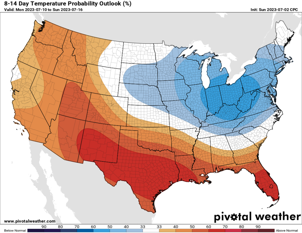
The latest 6-10 & 8-14 day outlooks are in.
The death ridge looks to come back in a weeks time. Enjoy this week’s rains, it looks like summer of 2023 is a write off.
See you for pumpkin spice brunches is October.
I love this weather. Rain and warm. I wish it would rain all night so the fireworks will be minimal. I cant stand them.
Yes especially when you have to work the next morning.
if 6/23 is tied with 6/80 for 6th hottest, when were the other 5 and how do they relate to a strong El Niño?
The hottest June on record was last year 2022. The 2nd hottest was 2011. The 3rd hottest was 1906 the 4th hottest was 1998 and the 5th hottest was 2009. There isn’t really much of a correlation between strong El Nino’s and hot June’s. 2011 and 2022 were both La Nina years. 2009 was an El Nino year but it wasn’t a strong El Nino at least not in June. I think in 1998 we had a transition from El Nino to La Nina but I’m not 100% certain. 1906 was an El Nino but idk how strong it was. Summer weather tends to vary dramatically year to year in SE Texas regardless of ESNO conditions. It may play a small role but many other factors could be at play that I don’t know about. Overall I think warmer than usual Gulf temperatures and the urban heat island effect is making it easier for more temperature records to be broken these days. The data I looked up was in the city of Houston. Urban development has been increasing alot in Houston over the decades. Overnight lows and high temps are typically several degrees cooler in the rural areas outside of the city. However average temperatures are going up in rural areas as well especially along the coast because of the warmer Gulf.