In brief: You probably don’t need to check the weather forecast every day, at least for the next few days, as our pattern looks to remain fairly consistent. Houston will see typical temperatures for June, with a smattering of rain chances through the weekend. Next week could be a little more dynamic as high pressure shifts eastward.
High pressure, but not HIGH pressure
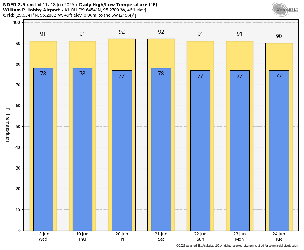
Houston remains largely under the influence of high pressure, expanding into the area from the southwest. But this is not a “death ridge” like we sometimes see later during the summer, when high pressure sits on top of the area and pushes temperatures up into the triple digits. As a result we are going to feel “June hot” for the foreseeable future, which is to say highs closer to 90 degrees than 95 degrees for most of the area. Rain chances will largely (but not completely) be squelched this week, but should improve to some extent next week.
Wednesday
I expect today to be a lot like Tuesday, with high temperatures in the vicinity of 90 degrees for most of the region. Skies should be partly to mostly sunny. Winds today do look a little bit stronger than yesterday, so we could see some southerly gusts up to 20 or possibly even 25 mph later this afternoon. I expect we will see some isolated showers and thunderstorms pop up this afternoon, but I would put chances at perhaps 10 percent or a only a touch higher. Lows tonight drop into the upper 70s.
Thursday and Friday
These days will be similar, with mostly sunny skies and high temperatures probably slotting in somewhere between 90 and 93 degrees. I think wind gusts will be a little bit lower, but rain chances a little bit higher. On Thursday, the Juneteenth holiday, there will perhaps be a 30 percent chance of rain, mostly during the afternoon, and maybe nearly that high on Friday. For the most part these should be quickly passing showers. Nights remain warm and humid.
Saturday and Sunday
The weekend looks more or less the same: highs in the vicinity of 90 degrees, mostly sunny skies, and plenty of humidity. I do expect we’ll continue to see some afternoon showers and thunderstorms, driven by the sea breeze. But whether these are isolated, or reach the point where they hit say 30 percent of the area, I cannot really say with confidence.
Next week
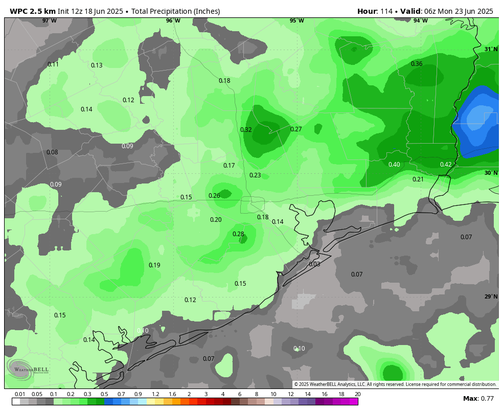
At some point next week the ridge will shift eastward, and as this happens our atmosphere will open up to somewhat better rain chances. Whether this happens by Monday or Tuesday, or later in the week, is difficult to predict. Temperatures, regardless, should remain in the range of 90 degrees. And hey, the longer we get into summer without a sustained stretch of temperatures in the mid- or upper-90s, the better to me.

So far, these High pressure ridges are mobile, moving around from spot to spot.
I have peeps in the Big Apple and the buzz is how they’re going to deal with a Death Ridge next week. All we can say here is welcome to our world, and unscrew a fire hydrant or two like we did way back in the day up there.
It could be worse, here is the forecast for Denver:
Fri 20
Mostly Sunny
101°/66°
Sat 21
Sunny
100°/64°
@Kenneth … we watch “Fox Weather” channel off-n-on throughout the day (24-hour weather channel that concentrates on the whole of the US; 26.3 OTA, also live website). They’ve been reporting on excessive heat up in the northern states …such as this article: “New York City, Philadelphia to flirt with 100 degrees as potentially dangerous heat wave grips I-95 corridor”
Aggie, living in Denver some years ago the weather during the summer was usually delightful, what drove us away eventually was the bitter cold of the winter. But then Denver was half the size it is now. Rapid growth over a few decades has created a huge concrete mass – same as Houston. Major cities everywhere are becoming unbearable.
The 64-66 degree lows indicate much lower humidity. Could well be better than what we will have.
Oh, no! Not near-normal temperatures!
Queue the wailing and gnashing of teeth.
In the news….Caribbean sponges that live 500-1000 years indicate we blew past 1.5C in 2020. Oh my, tell us something we don’t know. Buckle up Houston, it’s going to get warm soon.
Will we see impacts from Hurricane Erick?
Read the sister-website … “The EyeWall” for details.
“Erick will dissipate over Mexico as it lifts north inland over the mountains.”