In brief: After our cold start this morning, warmer weather will come roaring back today and Wednesday, which will be characterized by strong onshore flow. Thursday looks particularly warm, but conditions turn more pleasant this weekend.
Onshore flow returns in a big way
It is quite cold across the region this morning, with temperatures generally in the mid- to upper-30s across the region. The other thing to note is that winds are calm. That will start to change by mid morning as southerly winds start to pick up, bringing in warmer and more humid air in from the Gulf. By this afternoon we could see gusts up to 25 mph or higher, and the warming trend will be full on. Overnight lows tonight, as a result, will generally be 20 to 30 degrees warmer than Monday night.
Tuesday
For those of us up at this hour, it’s a beautiful and clear morning, with a lovely sunrise. Those clear skies will persist through the afternoon hours, and we are going to see high temperatures rise this afternoon to between 70 and 75 degrees. As noted above, winds will be gusty, from the south. As moisture levels in the atmosphere increase, we’ll see some clouds develop this evening and during the overnight hours.
Wednesday
If you liked the onshore flow on Tuesday, you’re in luck. It could be even more frisky on Wednesday, with gusts up to 30 mph from the south. Skies, otherwise, will be mostly sunny with high temperatures of around 80 degrees. Lows on Wednesday night will drop into the upper 60s, and it will feel modestly humid.
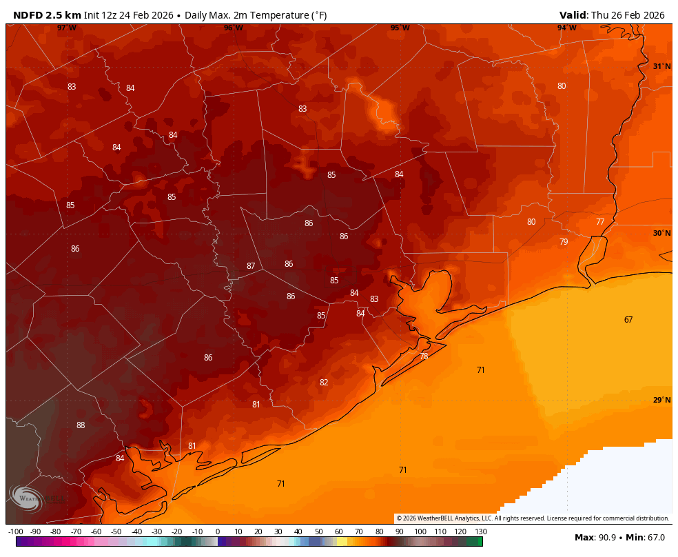
Thursday
This will be the warmest day of the week, with most of the area pushing into the mid-80s (possibly upper 80s for a few areas well inland) along with mostly sunny skies. Some parts of South Texas will be sizzling, and well into the 90s. A weak front will push through on Thursday night, allowing lows to drop to around 60 degrees for inland parts of Houston, with conditions a bit warmer near the coast.
Friday, Saturday, and Sunday
A generally wonderful weekend awaits us. Those strong winds we are going to see on Tuesday and Wednesday should be gone. Skies should be mostly sunny. And temperatures will be pleasant, with highs in the upper 70s to the low 80s, and lows in the 50s to around 60 degrees. Dewpoints won’t be super low, but they should be low enough such that it doesn’t feel particularly humid outside. In short, this should be a pretty spectacular weekend for any outdoor plans to have.
Next week
The forecast starts to turn fuzzy after Sunday. Another modest front could push through early next week, bringing a few nights in the 50s, or maybe it will stall before reaching Houston. Mostly we should remain in the vicinity of daytime highs around 80, and lows around 60. Unfortunately we probably are at least 10 days away from seeing any meaningful rainfall.
