In brief: Beryl has made landfall near Matagorda, TX as a category 1 hurricane with 80 mph winds. It will now move north across Matagorda and Fort Bend Counties into western Harris County, while slowly weakening. Heavy rain, flooding, more frequent strong winds, and isolated tornadoes are all likely as Beryl pushes northward this morning.
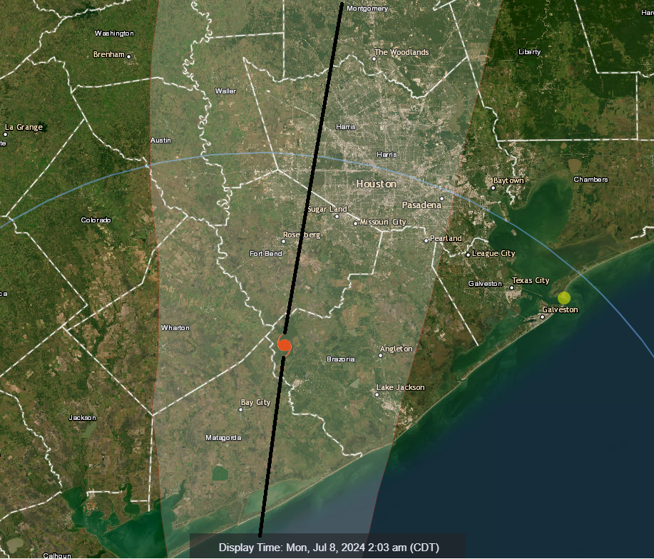
As expected, Beryl waited until the end of its time over water to really get itself together, and we are fortunate it did. Otherwise, we’d be having a much graver conversation this morning. Beryl made landfall around 3:30 AM just east of Matagorda and west of Sargent down in Matagorda County, not far from the Brazoria County line.
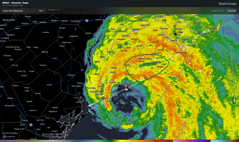
Beryl is moving northward around 10 mph and will begin to gradually weaken now that it’s over land. The current storm track puts the center on a course to pass across Fort Bend County and western Harris County on its way north. The worst of the wind and heaviest of the rain will be near that track and to the east, which encompasses most of the western half of the Houston metro area. Here’s what we should be expecting over the next few hours.
Wind: Wind gusts have been as high as 75 to 90 mph near the coast as Beryl has approached. Expect widespread 50 to 90 mph gusts across Matagorda, Brazoria and southern Fort Bend Counties as this comes north. Portions of western Galveston County as well. Numerous power outages should be expected. Wind gusts will diminish a bit as this moves into Harris County and northern Fort Bend, but still strong most likely in the 40 to 80 mph range, highest south and lowest north. Subtract another 10 or so from that for Montgomery County. Winds west of the center will likely be a bit under these values for all locations.
Centerpoint is reporting almost 50,000 customers without power as of 3:20 AM. Expect this number to increase.
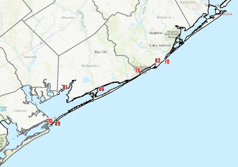
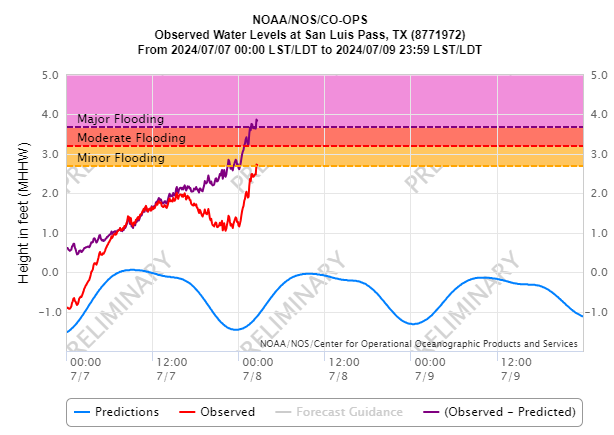
Surge: Storm surge has increased as I am drafting this post, up to around 3 feet or so at Sargent and 4 feet at San Luis Pass. Moderate flooding is underway as Beryl’s surge arrives. Water will peak soon if it has not already and will slowly decline over the next few hours.
Water will continue rising a bit longer on Galveston Island and in through the bays. Tiki Island is at moderate flooding levels now and a 3 foot surge. More flood gauges can be found here.
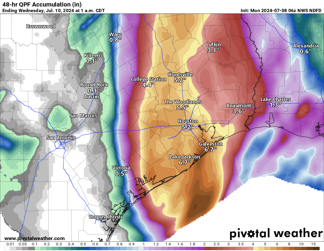
Rain: As expected, torrential rain is moving in with Beryl. Rates of nearly 2 inches an hour have been reported in the first major band of rain south of Houston as of 3:30 AM. As Beryl should track just west of Houston, the heaviest rains will likely be across Matagorda, Brazoria, Fort Bend, Galveston, Harris, and Montgomery Counties. Widespread street flooding is likely, and travel is discouraged until the rain tapers off later this morning.
Tornadoes: A Tornado Watch is in effect through 10 AM. I would expect to see a handful of tornado warnings come down over the next several hours as Beryl moves inland. They will move quick, so have alerts turned on on your phone or your favorite alerting app, and get to a low-level and/or interior room as quickly as possible if a warning is issued for your neighborhood.
Eric will have a full update on where things stand in just a couple hours, around 6 AM or so. Stay safe and dry everyone.
Thank you for all you do.
*currently wearing space city emotional support hoodie
Definitely a bit nastier as time moves on here on Tiki Island.
It’s rainining pretty steady here in Humble. Still have power, thankfully. Really appreciate Eric and Matt for all these updates and information. Stay safe, everyone!
Thank you for all you do to keep us informed. It makes a difference and we appreciate it..
Scary in a lake Jackson. Thanks for the updates!
Thanks for all you do! Ever since Harvey you’ve been my go to. The hype free voice of reason in the storm.
Using the app Windy, I noticed that wind speed was 70 over the Gulf but 35-45 over land. Was landfall having that much of an effect or am I misinterpreting?
I’m in Brazoria county and it’s pretty steady rain and wind here. Not too much flooding in this area just yet, but the wind is picking up. Still have power. Thanks for the updates Eric!
Thank you for being our trusted source!
Thank you for the update!
Thanks for your play by play and continued thorough analysis and assessments. Information is key and my family and I appreciate your zero embellishment approach to your reporting. Keep up the great work.
The Wesley Family in Rosharon Tx
Thank you for helping me keep my children safe. – Win
We’ve just lost power here in Fulshear, Cross Creek area
Thank you for staying up all night and providing updates. We appreciate everything you do.
Raising a glass (I think it’s a glass—I have no lights) to the intrepid Space City Weather team. Thank you for all you do.
Not the loveliest weather in Bellaire right now, but I was expecting much worse considering the colors on the radar. (Thank God)
Hopefully things remain fairly manageable as the morning progresses. Trying to stay very optimistic here.
We are here in Meyerland by the JCC. Winds are strong, rain coming down sideways!
Hang in there!
I’m in SW Houston and luckily, we still have power. You guys are so helpful for a worryless news (since I’ve recently become kind of a worry worm about severe weather like this) report of the weather and what it consists of and I really appreciate that! 👍🏼
Thank you for the updates! This is like your Super Bowl isn’t it?
Live in Sugar Land, not too bad yet. Looks like the 👁️ will pass right over us. Might be able to get some good pic’s. Just hoping we can keep power until sunrise. Thanks for the updates and knowledge you pass along.
I’m in SL too. Gusts are getting nastier. I checked the centerpoint outage tracker, and the # of customers affected count jumped by 60K within a couple minutes. Farther south from here, I think Greatwood is out, and there was a tornado warning. those winds should be here soon…
Flickering here and there, but power remains for us in Clear Lake.
Thank you for all you do! Powers out in MoCity.
Power down in League City as of 5 a.m.
Lost power in Brazoria 3:18am. Thanks for the update!
Steady rain and pretty strong wind in League City. Lost electricity around 5:00 a.m.
Thank you, all of you, for your hard work and much appreciated updates!
Many thanks for all that you do for us.
Water has filled the ditch outside but has not covered the road (yet). Just outside 610 north.
Power out in Nassau Bay since 357. Went outside around 0520 no street flooding but lots of tree debris on the street and the trees are taking a pounding, but still upright for now.
Thank you for all you’re doing! We moved away literally during Harvey and happen to be in town for Beryl lol. I’ve haven’t missed Houston weather but I knew right who to come to! Y’all help this GA girl who married a Texan not worry as much unless it is needed!
Hours of wind and rain. Must try not to stress out. Our power is still on for now near Champions but it has already flickered off and on several times. Hoping for a fast weakening of Beryl…
Thank you for your diligence and knowledge!
Just lost power in atascocita.
Adding my voice to the chorus of THANK YOUs — very grateful for your work!
So appreciate the detailed no-hype updates. It’s been steady since a little after 3am and power’s out now in Richmond.