In brief: In today’s post we discuss the recent and ongoing sea fog as well as our warmer than usual temperatures. Then our attention turns to the likelihood of storms this weekend as a front sags into Houston and brings much needed rain.
But first, some chat about fog on the blog
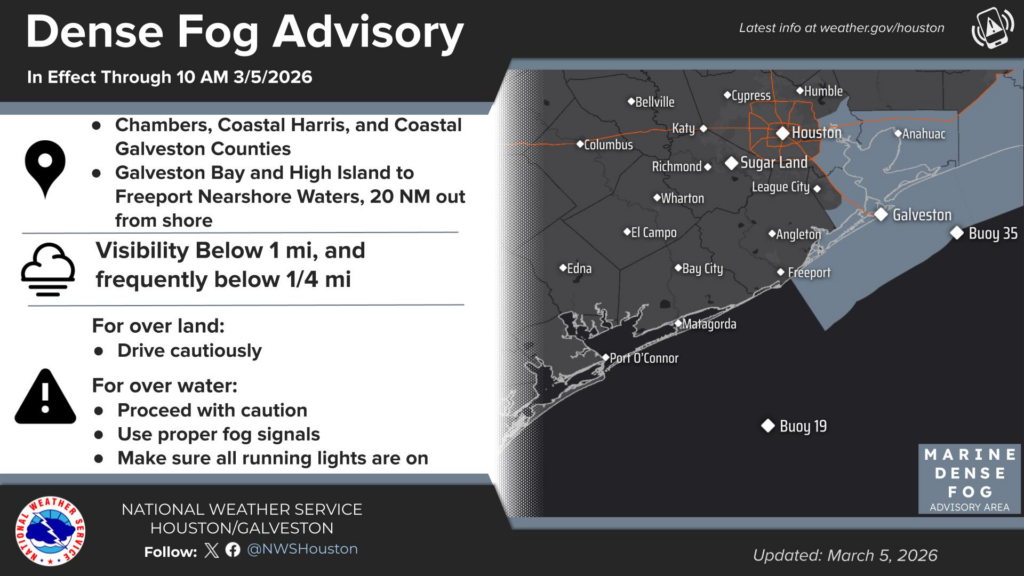
Are you tired of the fog yet? I know some readers like the eerie quality or semblance of “stillness” that fog brings. But if you need to be out and about late at night or early in the morning, it can be a real hazard. We’ve been seeing frequent fog near the coast this week, and this “sea fog” is due to the warmer air moving over cooler surface waters near the shore. Unfortunately, with the warmer temperatures we are likely to see through the weekend, sea fog will remain a persistent threat during the late evenings through mid-mornings for some coastal locations.
Thursday

Cloudy skies this morning will give way to partly sunny skies this afternoon, with high temperatures likely topping out in the low- to mid-80s. This will depend on the extent of sunshine at your location. We did see a few very light sprinkles on Wednesday in parts of Houston, but I feel like, overall, our chances for rain today will be pretty close to zero. Humidity levels will remain rather high for this time of year.
Rodeo forecast
It’s going to be fairly warm this evening, with temperatures in the upper 70s. The other defining feature that rodeo goers will experience is gusty southerly winds, perhaps up to 25 mph, although these will die down as the evening progresses. Temperatures after the show will be the in the 70s, only falling to around 70 degrees by early Friday morning.
Friday
This day will be rather similar to Thursday, with two possible changes. First of all, those southerly winds might be even a little bit stronger, gusting up to possibly 30 mph from the south during the afternoon. The other difference is that there is perhaps a 30 percent chance of light showers during the daytime or evening. Lows, again, will be very warm for early March.
Saturday and Sunday
So will the weekend bring a rain-o-rama? It’s still a little difficult to pin down precise details, but roughly speaking here’s what I think will happen. Saturday will be another warm and humid day like those preceding it. There will be a better chance of light daytime showers, perhaps on the order of 30 percent. But I don’t expect these to be significant or disruptive.
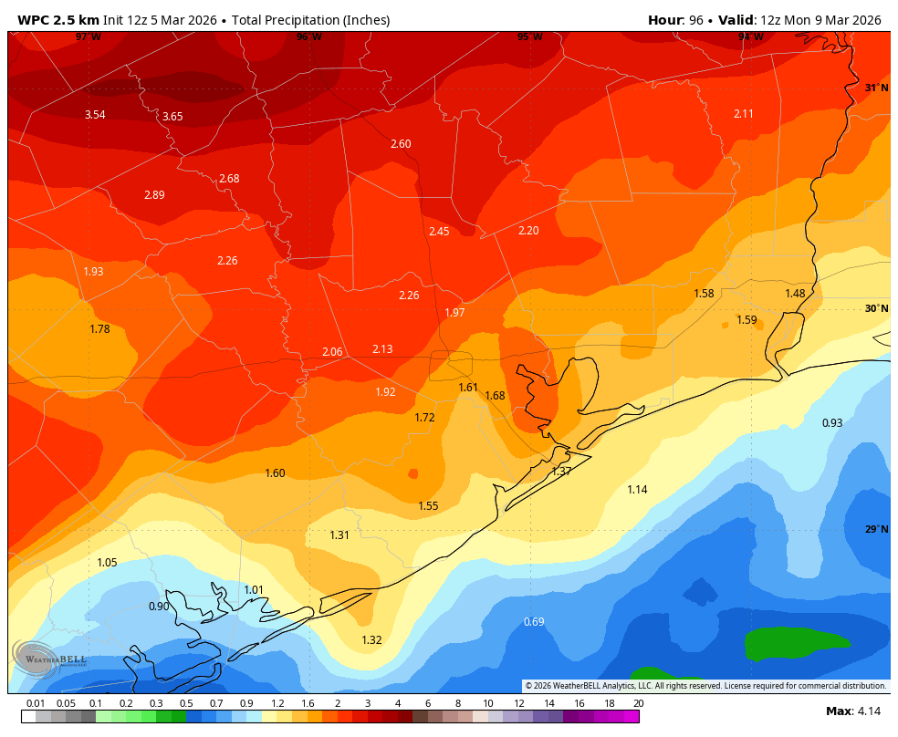
On Saturday afternoon or early evening a (dying) front is going to approach and potentially move into the Houston metro area. I expect there to be a goodly number showers and thunderstorms with this front. Whether these storms make it all the way to the coast will depend on where the front stalls, but at this point I think there is a decent chance of everyone seeing some rain. I’m hopeful, for the purposes of our spring vegetation, that we pick up 0.5 to 2 inches this weekend, with higher isolated totals, but again some uncertainty remains.
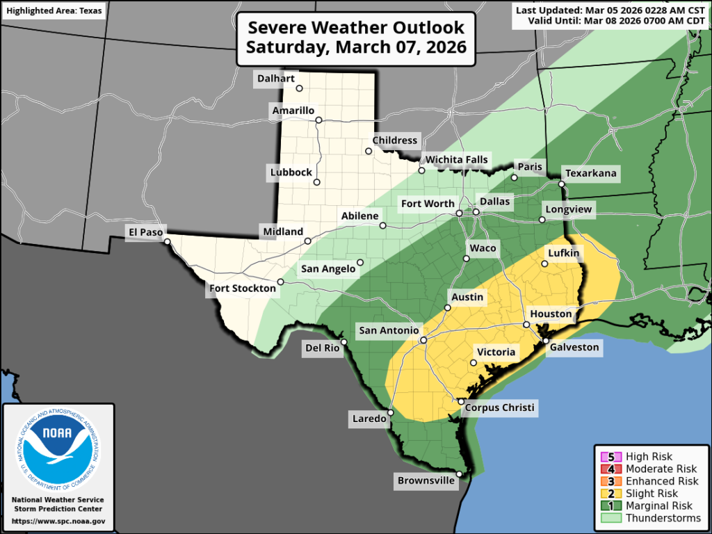
I mentioned thunderstorms and there is slight risk for some severe weather with this front as it moves in and stalls, and again I think the most likely timing for this is probably Saturday evening. So bear that in mind if you’re planning to be out and about.
Sunday, for much of the region, should be a few degrees cooler due to widespread cloud cover, the aforementioned front, and ongoing rain chances during the day. The potential for thunderstorms and severe weather should be diminished however. The bottom line is that from Saturday afternoon into Sunday morning we’re going to need to be mindful of the possibility of thunderstorms and heavy rainfall, but I’m not saying everyone will see these conditions.
Next week
Monday, Tuesday, and Wednesday of next week will see ongoing warm temperatures, with highs in the low 80s and mostly cloudy skies. There will be a modest chance of daily rain chances. A front should arrive some time on Wednesday to bring us clearer skies and drier air and probably a few nights in the 50s. Two weeks into March it may finally feel like March.