In brief: Houston’s pattern will continue to bring a chance of daily showers. For the next two days, in particular, much of the region should see rain and a bit cooler temperatures. We should get back into the mid-90s later this week, and into the weekend. So basically, it will feel like July in July.
A year since Beryl
Conditions are quite a bit nicer this morning than they were one year ago today, when Hurricane Beryl made landfall down the coast from Houston. At this time we were seeing maximum winds across the region, with gusts above hurricane force strength affecting much of the area. This caused significant tree damage and knocked power out to millions in the region. So it is not a particularly happy memory for most of us.
Tuesday
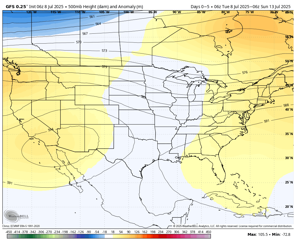
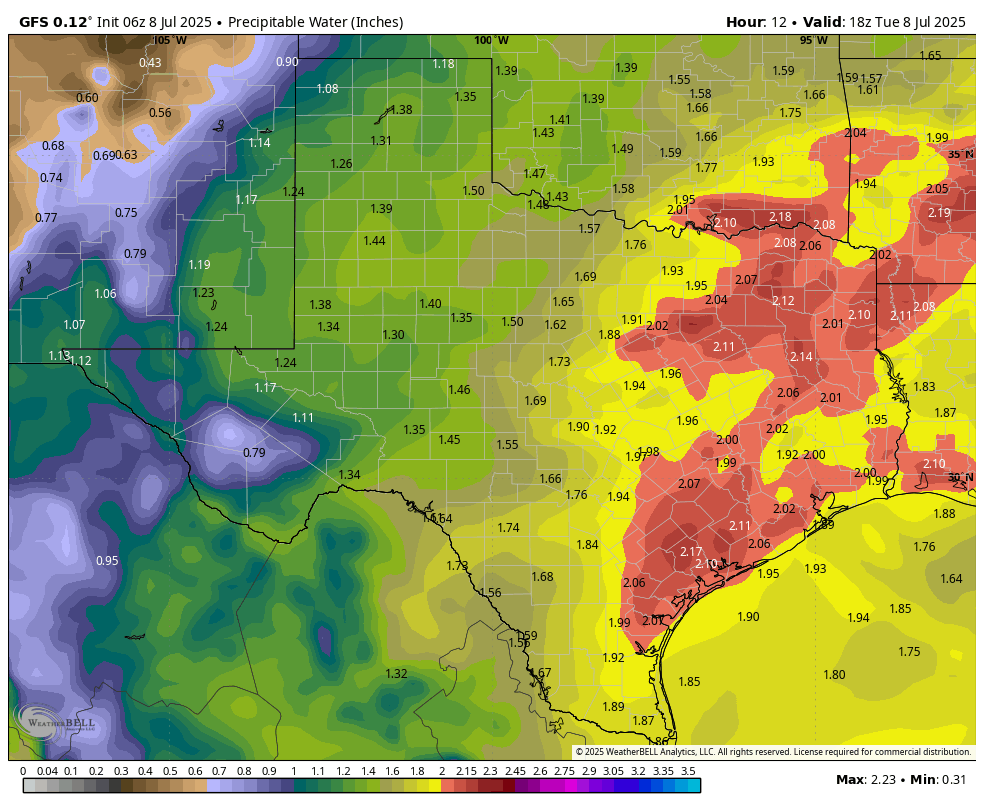
A couple of factors will support ongoing, healthy rain chances across the Houston region this week. These conditions, the combination of lower pressure and lots of moisture in the atmosphere, should be especially pronounced today and Wednesday. As a result we should see the development of fairly widespread showers and thunderstorms.
As usual, these showers will be hit or miss. They will start out closer to the coast later this morning, and then spread inland throughout the afternoon and early evening before waning after sunset. Some locations may pick up 1 inch of rain under stronger storms, whereas as other locations will only see light rain or dark skies. You’ve seen this story before in Houston. Most locations, on average, should pick up a few tenths of an inch of rain by the end of Wednesday.
Partly to mostly cloudy skies this afternoon, in addition to rain-cooled air, should help to limit high temperatures to the lower 90s. Winds, generally, will be light at 5 to 10 mph except within stronger thunderstorms. Lows tonight will drop into the mid-70s for most locations.
Wednesday
This will be a similar day to Tuesday, with rain chances above 50 percent. Again we can expect a few thunderstorms, but mostly I think these will be light to moderate showers. Highs, again, will be in the lower 90s.
Thursday and Friday
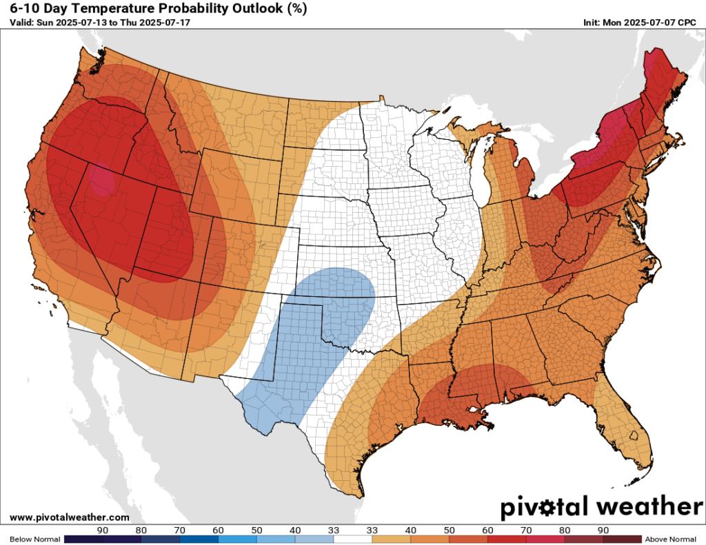
The second half of the week should bring somewhat lower rain chances, but they still should be somewhere in the 30 to 50 percent range. Accumulations will be less for most locations. Accordingly, daytime highs will be a little bit warmer, in the mid-90s for most locations. This is plenty hot, but also pretty much par for the course in mid-July.
Saturday and Sunday
Unfortunately I still do not have a great handle on the outlook for this weekend. It depends on the extent to which high pressure can build up over the area, and there is no agreement in the various models I am looking at. My sense is that we’ll see highs in the mid-90s, with a decent (i.e. maybe 30 percent) chance of light to moderate showers each day. Hopefully in another day, or so, the forecast will come into better focus.
Next week
Overall next week looks a little bit warmer, with high temperatures in the mid-90s, and possibly some areas sneaking into the upper 90s. I think rain chances may step back a little bit, compared to this week at least, but I’m not sure the spigot will be entirely shut off. Basically, July will continue to do July things, probably.

“When all is said and done, the weather and love are the two elements about which one can never be sure.” -Alice Hoffman
I would not exactly call this the “year without a summer” but it’s been very normal up to this point. If you are doing the math it’s been 320 days since our last triple digit reading at IAH. That’s a good thing.
So true. While this summer is still averaging above normal, it has still been a walk in the park compared to the brutality of the summers of 2022 and 2023.
I’d be curious to see a comparison of the wet bulb temperatures; 2022/2023 were top-line # hot, but iirc a lot of that was drier… gardening this year has been more brutal than I remember those years
My wife and I chose our wedding date, July 8, because we thought there was a lower chance of a hurricane impacting the day. We have lots of teachers in our family, so we wanted a summer wedding. A/C exists, plus we got a nice venue discount for choosing a summer date.
Thankfully, we were right about hurricanes when we got married in 2023. We were in Seattle on our first anniversary as the eye of Beryl passed over our home. Phew.
My wife and I were married on July 10th, 2004. Last year, on our 20th wedding anniversary, my wife and daughters left me……to go to my in-laws because they couldn’t take no power and AC. I had tickets to the Astros game the next night. So I went on Friday and took the cat with me, which was fun. For someone.
I wonder what is the lowest mean temperature for Houston in June and how this past June ranks? We’ve had a nice (in Houston terms) summer so far it seems, aside from skeeters.
Artificial Intelligence quotes the Greater Houston Partnership. This is most likely not the information you are looking for. In June, the average high temperature in Houston is 91° Fahrenheit and the average low temperature in Houston is 72° F.
The coolest June on record for Houston was in 1919 with a mean temperature of 77.5. This year was actually the 10th warmest June on record for Houston with a mean of 84.7.
While this past June was realitively temperate compared to some of our recent June’s, it was still well above normal when compared to the historical average.
“Temperatures next week look somewhat warmer than normal”.
It’s July. Temperatures are normally warmer than normal in July.
According to the Greater Houston Partnership, the average high temperature in Houston is 94° Fahrenheit and the average low temperature in Houston is 74° F.
If we had Beryl in her prime, we would still hear the sound of hammering nails and sawing wood to replace rafters today.
Right front quadrant of a 160 mph buzzsaw? Fughettabouttit.
Facts. There would still be people without a home sadly enough. We were very lucky that Beryl’s development was being suppressed by that plume of dry air that intercepted its circulation in the Gulf or it would have been much worse.
There are still people suffering from Beryl. Roofs all over the city were weakened & damaged. Then the lack of electricity. Breeding ground for mold that’s still going on now. Silent spread of toxicity.
🙁
Well I got 4 1/2″ of rain from 11:30 to 3:30 yesterday afternoon in Liverpool!
Any day the ridge loses is a day that Houston wins.
Barring a hurricane, of course.
It’s raining here again. A real gulley washer. I’m not familiar with this kind of weather. The barometer says it should be sunny. Pressure aloft is a ridgey 592. What’s up?
Same we just had a storm in Sweeny with several close lightning strikes. The first one started the heck out of me because it happened before the rain even started. We are in between 2 upper level riges which I assume helped trigger more efficient lift in our atmosphere. Plus I heard the other day that an upper level low in the Gulf was also drifting our way.
I guess what you’re saying is two ridges side by side requires some troughiness(?) and lift in between. Vapor just needs to rise and get to its dew point to rain. Doesn’t care what the pressure is! The southern trough in the model gets in tomorrow night. Can’t do weather with just a barometer here in Houston.
Essentially yes
Pouring here in The Heights. Thunder and lightening. ( The way you love me is frightening.) sorry couldn’t resist.
🤣
Hooks airport just recorded 21.1C (69.98F) air temperature. Is that legal in July?
Quite a few PWS stations around us show 70°F -71 here in Magnolia at 6.45am Wed.