In brief: We sincerely hope everyone is enjoying a bit of relaxation over the Labor Day Weekend in Houston. As meteorologists, of course, when the weather is weather-ing, we’ll be here to cover things regardless. And we will continue to see additional showers and thunderstorms today, particularly south of Interstate 10. Also, it really does appear as though fall’s first front arrives next weekend. Cannot. Wait.
Labor Day
We are seeing the development of widespread showers over southern parts of the Houston region this morning, in locations such as Texas City and Galveston Island. As a low pressure system wobbles offshore, the greatest threat of heavy rainfall now lies primarily to the south of the Houston area (rather than to the east, as it was earlier this weekend). Galveston, Brazoria, and Matagorda counties are at the highest risk of heavy rainfall today and tonight, and so we are maintaining a Stage 1 flood alert in effect for those locations.
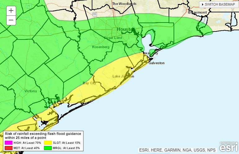
For the bulk of the Houston metro area, today will bring an ongoing chance of showers and thunderstorms. Most locations have perhaps a 50 percent chance of seeing rain today, which is something to keep in mind if you have Labor Day plans. Otherwise, expect partly to mostly cloudy skies with high temperatures in the upper 80s to about 90 degrees.
Tuesday, Wednesday and Thursday
We’ll continue to see healthy rain chances for these days, but my sense is that the threat of locally heavy rainfall should diminish a bit, even for coastal areas. Sometime later this week, perhaps by Thursday afternoon or evening, we should start to see a clearing pattern. Until then, we can probably expect partly to mostly cloudy days with highs around 90 degrees.
Friday, Saturday, and Sunday
We should see mostly sunny skies for the weekend in Houston, with much diminished rain chances, at 20 percent or less. Friday and Saturday should be fairly warm, with highs in thew low 90s or thereabouts. However, our confidence is increasing in the arrival of a cool front on Sunday or Sunday night. This does appear to be a bonafide cool front, with a decent push of drier air, but since we’re still in early September I want to temper expectations.
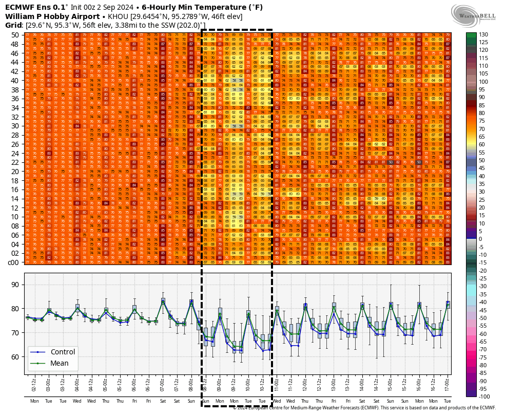
After the front’s passage we will see dewpoints fall, and noticeably drier air. High temperatures are still going to reach the upper 80s, with mostly sunny skies. But mornings, evenings, and nights should feel pleasant through about Tuesday or so. Inland locations will probably see nighttime temperatures in the 60s on Sunday and Monday night. This would be a couple of weeks earlier than normal for Houston’s first real fall front, so it is definitely something to savor.
Tropics
There’s activity out there, but not a whole lot I would be particularly concerned about at this time. Stay tuned to The Eyewall for in-depth updates.

Cool front, cool front, cool front, cool front…
Hopefully the heavy rains hit somewhere else besides the beach today. Some of us a few miles inland still have not had a good soaking rain yet.
Is this cool front good or bad for Houston relative to any low pressure that is in the Gulf at the same time or during the days just after? Can this cool front create a corridor pulling a storm in the Bay of Campeche toward Houston?
Cool fronts push them away from us. When cool fronts start coming, it usually means the hurricane season is over for us.
Usually yes, but there have been storms in September come near us in the past
True. But they only seem to hit if a cool front has not made its first appearance yet. Even one usually shuts the door for the season
Thank you for bringing us a cool front this weekend upcoming. We appreciate when you bring is good weather.
That’s usually the beginning of the end for Texas hurricane season.
First Cool Front
Houston’s Official, most Joyous, Holiday celebration by Eric Berger
Probably.
Love, with all my heart, a cool front coming!
But I don’t understand the left side of the chart you posted. And I did see some gray squares. Will those be for North Texas?
Thanks for the update, Eric!
I remember hearing that once the first true cool front pushes all the way through the area and offshore, the chances of major hurricane activity in the Houston area drops off dramatically. Am I remembering correctly, and if so, does this cool front qualify as strong enough?
Ahhh … the annual September tradition of predicting a cool front in Houston that does not materialize into anything even slightly meaningful. Fingers crossed for October though.
lies, its tropical here. Stop the ridiculousness
Yeahhh!! Cool front!!! Does that means no more hurricanes??