In brief: Houston still has a few chances for some scattered showers today and Saturday, but for the most part we are going to see sunny skies for awhile. The biggest news today is that a cool front, perhaps the final one of this spring, will slowly push into the area today and tonight. This will set the stage for a grand weekend of May weather.
Cool fronts
Ahh, cool fronts. Is there anything better in Houston than that? I mean, the food around these parts is pretty darn good. The people, when they’re not screeching along freeways, are generally quite friendly. You can find a good living here. But for me, there is not much in this southern city to beat a cool front that comes along and knocks down the humidity, allowing us to pretend we don’t live in a jumped-up swamp.
I love cool front season. I live for cool front season.
Houston got its first (admittedly weak) front of fall last year in late September. On the 27th of the month, the temperature at Bush Intercontinental Airport dipped below 64 degrees. That means we’ve had 222 days during which we might reasonably hope for a cool front in Houston. It’s been a good run, but I’m afraid it’s about to end.
Today and tomorrow are going to see dry air slowly percolating into the area, such that Saturday, Sunday, and Monday aren’t exactly going to feel humid outside. It won’t be particularly cool, mind you. But it won’t be hot, either, and the air won’t feel sultry. For this time of year we cannot ask for much more. I’m also not entirely ruling out one more (almost certainly weaker) front later in the month. It’s possible. But I wouldn’t bet on it. I’d bet on summer. But hey, I just checked, and the end of September is only 20 weeks away…
Thursday
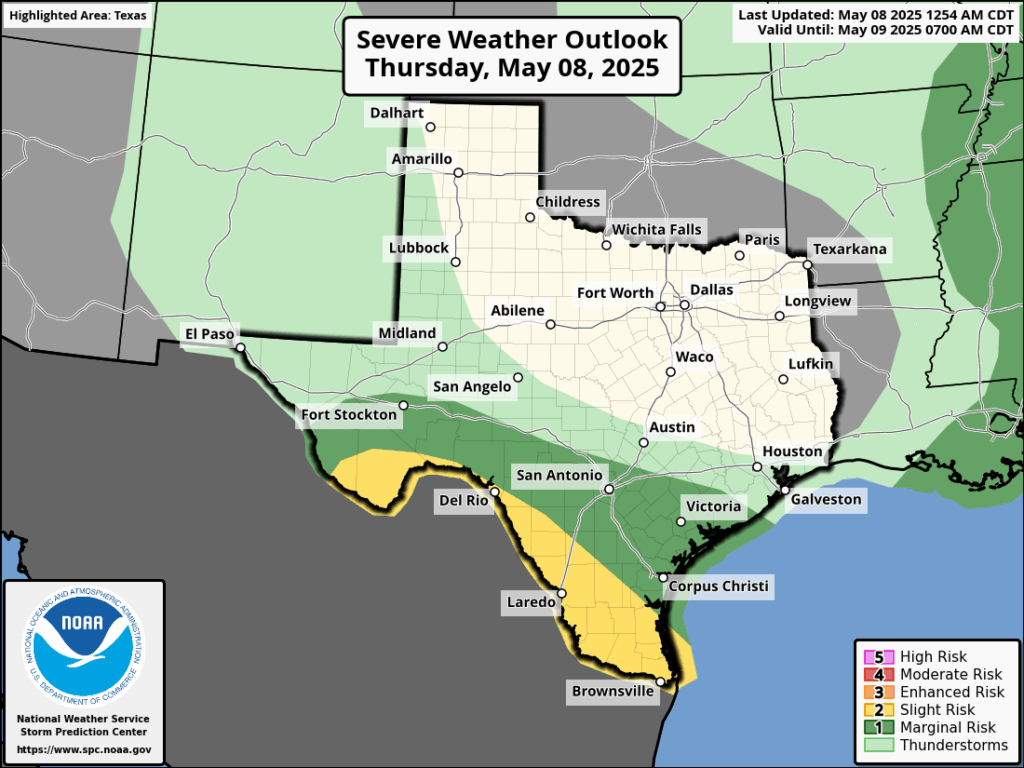
Today will be sunny and fairly warm, with high temperatures reaching the mid- to upper 80s with a fair amount of humidity. Winds will generally be light, from the northeast, at 5 to 10 mph. Late this afternoon, and evening, an atmospheric disturbance will approach from the west and this will introduce a chance of showers and thunderstorms. I think overall rain chances are only about 20 or 30 percent, and the primary time frame will be this evening or during the overnight hours. We could see a few thunderstorms as well, and we cannot entirely rule out some of them becoming severe. However, I doubt it. Lows tonight drop to around 70 degrees.
Friday
Winds will come more prominently from the north on Friday, and this will start to bring some modestly drier air into the region. Highs will likely only reach the lower 80s on Friday under mostly sunny skies. Lows on Friday night will drop into the mid-60s.
Saturday
Highs on Saturday may only reach the upper 70s, with mostly sunny skies. There will be enough of a disturbance in the atmosphere that we may see a few scattered showers later in the day due to daytime heating, but overall chances are quite low. Temperatures on Saturday night should drop into the upper 50s for some inland areas, while remaining in the lower 60s closer to the coast.
Sunday
Mother Nature is bringing the goods for Mother’s Day this year, with a lovely day in store. Expect mostly sunny skies, highs of around 80 degrees, and moderate humidity levels. Really, an A+ day for mid-May. We’ll have one more somewhat chilly night on Sunday.
Next week
We’ll see a warming trend next week, and by Tuesday or Wednesday we’ll begin a stretch of at least several days with high temperatures in the 90s with plenty of humidity. Rain chances appear to be low at least until next weekend. It is that time of year.

Eric, I do so love your writing style; your commentary this morning made me smile. Thanks.
While I would love to see daytime temperatures in the low-mid 70s with the cool front, I’ll take the lowering of humidity. I dread the start of summer and the thought of walking outside only to be met by an absolute blast furnace.
I normally calculate around 150 days of summer; give or take. This year we may take away since these perfectly timed weekend cool fronts in mid-May have helped. And, if we get lucky, we may get a cool front earlier on in September and who knows; late August! Climate change can go both ways! Excellent post Eric.
“Rain chances appear to be low at least until next weekend. It is that time of year.”
Is it? May and June are historically the wettest months in Houston. Coming up dry in the near term would be disastrous given the likelihood of death ridge in July-August. We need more rain!
According to NOAA, October is wetter than May. Generally speaking, the wet season is May through October, but we’re talking about the difference between 5-6″ per month & 3-4″ per month.
Settle down before you get the drizzles, what we call a drought in southeast Texas would be called a good year in west texas.
Houston is not west texas, right to be concerned of future drought conditions
yesterday ending up being quite nice, the rain ended by 10 AM, and then the weather turned sunny and mild
🎯
Like I said yesterday the first two weekends in May is fantastic. I do like summer time even when I lived up north, yea its melting hot in the summer per say but I always remind myself growing up with winters highs 10-20-30 degrees snow up your @&%. Been hear since 91 retired now no regrets. My saying is I don’t know anyone having a beer on there back porch when its cold and wind chill makes it 5-10 degrees.
Every year is different. Even though you can add up and analyze the numbers and talk about averages and what “typically happens “ in any given month or season in Houston it doesn’t mean it will be that way this year. Very few years can be considered “an average weather year “ in Houston.
It has been that way since I have lived here, which is many decades. We could see weak cool fronts providing nicer weather as late as Memorial Day or as early as early as Labor Day. And extremely hot and humid months of May and September. The issue now is the lack of rain that some parts of the vast area SCW tries to forecast the weather for are experiencing. There are definitely some areas that are seeing drought conditions. Like my yard.
The thing with Houston is, we could see the deficit in rainfall all made up in just a very short period of time.
It has been a great Spring—more rain for us on the west side would have made it really great, but yes, can’t complain!
Getting some pretty good rain right now in Meyerland, much more than we expected.
SCW should publish a postmortem on the previous day’s forecast. For instance, tomorrow May 9 would include a bot’s analysis of the “today” portion of the May 8 forecast against what actually happened.