In brief: After enduring one of the longest, strongest late season heat waves on record in Houston, we will begin to slowly reduce heat after today and tomorrow. Look for slightly “less hot” weather next week and an opportunity at a weak cool front. We’re also watching the tropics but are not currently too worried about what develops near the Yucatan as it pertains to Houston.
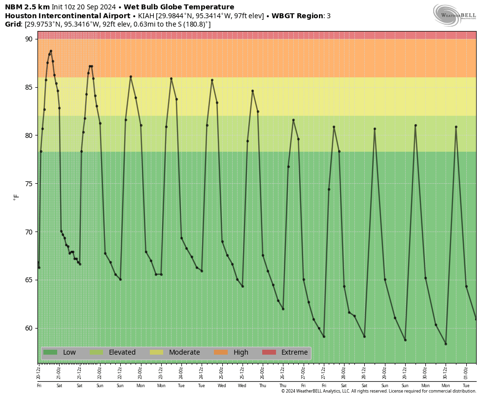
We hit 98 degrees yesterday officially in Houston, our seventh straight day above 95 degrees that began on September 13th. In the history of Houston’s weather records back to the 1880s, a one week stretch above 95 degrees has not ever occurred after September 13th. We had a couple five day stretches back in 2011 and late last September but never a week. If you’re like me and hate September because it only teases and never delivers autumn in any lengthy fashion, then this stretch of weather inspires much loathing. It’s just that it hasn’t been this hot for this long this late in the season before in Houston. We may make a run at an eighth straight day of this today, but the good news is that change is on the horizon.
Today through Sunday
Today and tomorrow should be similar in nature, with highs generally in the mid-90s, give or take, with limited rain chances. We will probably get the same out of Sunday, though it may be a degree or two cooler. It should still be above 90 though. Morning lows should be stable, generally in the mid-70s. If you’re out for a morning walk, it’ll really depend on exactly when you step outside. Either way, it will be quite humid.
Next week
I get the sense that next week is the week we really start to transition to autumn. It won’t be cool and refreshing by any means, but we will see high temperatures shave off a degree or two each day. We’ll start the week on Monday likely in the low-90s and finish the week in the upper-80s. Morning lows will go from the mid-70s Monday to the low-70s by Friday.
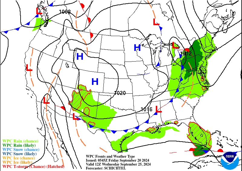
The Weather Prediction Center’s forecast map for next Wednesday does show a cold front pushing into our area. This won’t be a sudden ultra-refreshing change, but I think this will reinforce this idea of a slow drift back toward “less hot” weather next week. With high humidity early in the week and an approaching front there will be a slight chance of showers each day, especially south and east of Houston. But meaningful rain seems unlikely next week.
Tropics
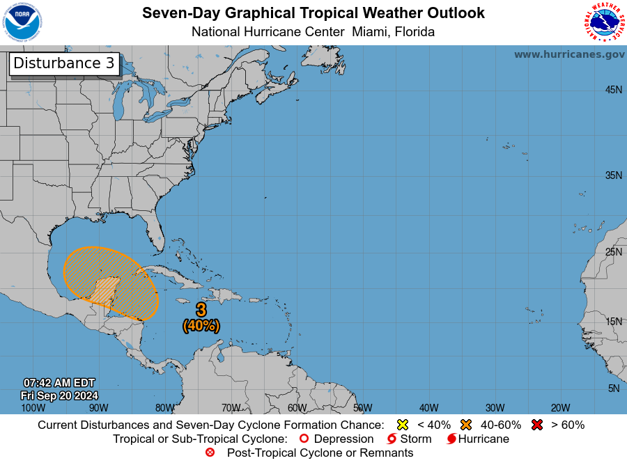
Yesterday evening I pushed a post out at our companion site, The Eyewall to discuss the latest on the Caribbean disturbance we expect to try to develop next week. In the post, I included a section about Texas and why I don’t believe this one is our storm. Meteorologically, the setup is such that whatever it becomes should move very slowly in the southern Gulf or near the Yucatan for several days before eventually getting scooped up by a trough in the Eastern U.S. and whisked off to the northeast. Overnight modeling did nothing to dispel that thinking on my end, so I’ll refer you to the post yesterday to get a better understanding of why we’re not currently too worried. That said, we’ll keep monitoring things this weekend and have the latest for you on Monday, assuming this remains likely to stay away. We will also update The Eyewall this weekend with more. For those of you with travel plans next weekend in that region, you’ll want to keep tuned in.

I am like you in that I really don’t like September.. I dread the continued heat and awful humidity while a hundred million others are putting light jackets on in the morning
I’m with you that I’m jealous of people in other parts of the country that are waking up to refreshing cool and crisp light jacket weather in September.
But, I like September because it is not August or July.
Having to watch the weather to see if late season veggies need to be covered overnight is not all that great, refreshing but still a pain.
Houston has only two seasons – Stinkin’ Hot and Not-So-Stinkin’ Hot.
That’s why deodorant was invented.
This week has just been September being normal September. It’s still a summer month. It’s this way every year.
Maybe you missed the part where this sustained stretch of high heat has never happened in recorded history. September is hot, but not this hot, so late into the month, for so long.
You’re talking stats and the original Scott is talking about the experience. He’s nailed it, because EVERY September, since I moved here four decades ago, has been hot and humid. A degree or two up for X number of days that hasn’t happened before doesn’t change the experience one iota. Is the statistical aspect notable? Of course. But it’s completely detached from the fact that lingering unpleasant heat and humidity in Houston in September is normal.
You misspelled it … it’s Sweatember.
We really need lots of people to just pack up and move on from this area. If you can’t take the heat get outta the kitchen.
It’ll do this region a favor.
I do my best to spread the word to all the Californians how nasty it is here but they continue to move here in droves.
My gf is from San Diego, and I’m native from here along gulf coast. They all coming here for cheap cost of living. Better be able to handle it. She likes heat though.
Boy, CHEAP is the right word. The cardboard apartments springing up are so thin, lousy, tiny, dark and box like. The walls & roofs are so thin, a tent is almost comparable.
You need a dehumidifier to keep the air breathable. The rents outrageous. The managers oblivious. The housing here is in demonstrationable, fast decline.
The ‘houses’ springing up are equally shabby shacks, being built on the flood drainage areas no one would touch in the 80s. Naming half-swamp low land places ‘Bridgeland’ and setting up housing – it’s almost like mockery.
‘Rentention ponds’ and grey water lakes everywhere. Cestpools.
Nobody’s making you stay here. I hear California is nice.
That’s it in a nutshell. Most if not all of these builders are from other states, so they don’t care if their product defecates all over Houston. Plus, they consider anyone moving into their rack-shakes are too stupid to matter.
I think a lot of them are moving to the Austin area, but the truth is that even though it is a good ways west the dewpoints there are not much lower. Combine that with the lessened cloud cover they have, and you get plenty of awful heat.
Since it’s so nasty here, you’re free to leave.
Bye!
I cannot scroll by and let you get away with this comment without a rebuttal…
One of the things I’ve always loved about Houston was the friendliness and generosity of our people…Even if we all complain about the heat, lol…People in Houston still seem friendly, when I encounter them face to face..Which is a reason why I’ve stayed for 40 years and now have roots here….If many people made your comment to my face, I’d probably want to deck them and move the heck out of dodge..Why do people on the internet give themselves permission to be cranky snots? Just sayin….
And I’m not from California, I moved here from Tennessee:-)
Because it’s so very friendly to want to ‘deck people’ for simply expressing their opinion…
Just sayin
I agree, it’s not friendly for me to want to deck people if they tell me I’m not welcome in Houston, that I should move away, if I tell them I’m not in love with the heat, humidity and hurricanes….Who would really say that to my face, anyway, lol?
I’m just having more and more trouble tolerating meanness..
Why did post get hijacked about people arguing about states? lol.. More important things in life than to fight random people online
This is just more evidence that our summers are getting hotter and longer on average. They are starting earlier and ending later. It really drove home to me the reality of what is going on when he had heat index values of 116 last May. I predict that in the 2030s we are going to start seeing highs reach 90 degrees at times in November, December, and January. If I’m not mistaken climate scientists predict that by 2050 we will start seeing heat index values top 125 regularly in Texas during the Summer months. I do not plan on living here by then.
This hillbilly will probably move back to Tennessee if the heat becomes that extreme and prolonged….What my gut tells me is eventually, by the 2030s, we may see isolated time periods of extreme heat AND cold…
Why not get a head start and move away now?
wake me up when September ends
September can get the heck out. 🙁
Love the several “less hot” vs “cooler” mentions as virtually every dang weather dingus chooses to use. Well done. As for September itself, how bout we just consider June – September as “summer” as eliminate ALL ruminations about where the “cooler” weather is….
A good solution to the ceaseless theme “when’s the first cold front?” If it’s a dry front – and looking that way now – we will be sad and cool. Go tropics.
For the climate worried, article in WSJ today about tech to commercialize CO2 conversion to syngas using renewable electricity. Short of commercial fusion that’s pretty sweet.
June? Summer in Houston starts a few months before June. We have 90’s in April.
quote: “how bout we just consider June – September as “summer” …
You must have moved here in June of this year. Summer here begins around the April timeframe.
Hi A and B. More Friday funnies. I guess I would look at summer as when stepping out in the morning before dawn and it’s above 70. I myself do not enjoy stepping out in the 60s or lower. Last month of that is generally May and resumes in October. As others have said to live at 30 deg latitude adjacent the GoM is to expect highs in the 90s during 6 maybe 7 months. This be not unusual.
Mean feelings here today.
I think we’re all stressed about this ‘is this the 2nd one’ thing.
You guys are amazing! Thank you both for what you do for our community!🥰
Despite a really hot week September is only 1.0 degrees above normal for the month and Galveston is -1.7 degrees below. With the exception of the last week it’s been nice by our standards…
The morning walk is now a challenge, considering the high humidity, and yea, heat. When was it, a week or two ago, we had low humidity and less heat for a couple of days (?) … we walked double our usual morning distance.
And yea, predict landfall around Pensacola.
I cycled 63 miles today and can attest it was exhausting. The only way I can survive cycling in these conditions is to consume 24 oz of electrolyte enhanced water every 13 miles.
I should have been cycling in the UK this week, but I missed that. The temp. is in the 50/60’s there.