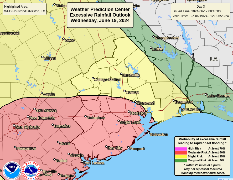
In brief: Our pattern is changing this week with arrival of tropical moisture. This will lead to heavy rainfall over the Houston area, especially on Tuesday and Wednesday. However, our concerns for Houston are lower today with much of our model guidances now projecting the most extreme rainfall further south, near the Coastal Bend and areas such as Corpus Christi.
Tropical moisture arriving
A surge of tropical moisture will move into Texas this week. However, based upon trends in the forecast over the last 24 hours, the threat of the heaviest rainfall has shifted south of the greater Houston region, including Galveston Island. This does not mean it is not going to rain in the Houston area this week. However, it does mean that our risk of seeing extreme rainfall totals and widespread flooding is lower.
For the time being we are going to maintain a Stage 2 flood alert for the Houston area through Wednesday given that the potential for high rainfall rates remains. Localized areas, especially near the coast, are still likely to see flooding. However, a Stage 2 event for Houston can now be considered a worst-case risk scenario.
Monday
A large area of low pressure in the far southwestern Gulf of Mexico is starting to push a surge of moisture toward Texas this morning, and we’ve already seen some streamer showers. Atmospheric moisture levels will rise today, and as a result this afternoon I anticipate seeing fairly widespread showers and thunderstorms. A few areas could quickly pick up a couple of inches of rain, but totals for most locations should be less. Rain chances will slacken a bit tonight. With partly to mostly cloudy skies, highs today will be in the upper 80s for most locations.
High seas, high winds
Beginning today we’ll also see increasing winds from the east due to the low pressure system. These will peak on Tuesday and Wednesday. While they won’t be too significant for much of the area—we are talking gusts of up to 25 to 30 mph—they could be higher along the coast, including Galveston Island. A coastal flood watch is also in effect for this week, with tides likely to run a couple of feet higher than normal, and a high risk of rip currents. Low-lying coastal areas may flood.
Tuesday and Wednesday
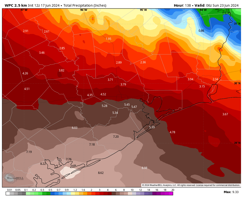
These days will see the highest threat for heavy rainfall, as tropical moisture levels peak in the atmosphere. As noted above, a majority of our modeling now indicates that the greatest potential for heavy rainfall—that is, the areas where we could see 12 inches or more of rainfall—are now south of Houston, in locations such as Matagorda Bay and Corpus Christi.
That does not mean that Houston is out of the woods, so to speak. The environment is still favorable for heavy rainfall this week, it’s just a bit less favorable. In terms of expectations, much of the area along and north of Interstate 10 is likely to see between 1 and 5 inches of rain this week, with areas south of the freeway and closer to the coast likely to see 3 to 6 inches. The risk, for coastal areas, is that localized areas could see higher amounts. That remains possible given the state of the atmosphere. And high rainfall rates can quickly backup streets.
Highs on Tuesday and the Juneteenth holiday are likely to be in the low- to mid-80s due to cloudy skies and the likelihood of rainfall.
Thursday
Rainfall remains possible on Thursday, even likely. But as moisture levels start to decrease, so too will the threat of heavy rainfall. Look for highs in the upper 80s with partly sunny skies.
Friday, Saturday, and Sunday
We should see the return of partly to mostly sunny skies for the weekend, with highs in the upper 80s to lower 90s. However, as high pressure is unlikely to be in total control, each day may well have a decent chance of afternoon shower and thunderstorm activity with daytime heating. We’ll see.

“However, a Stage 2 event for Houston can now be considered a worst-case risk scenario.” Be careful saying stuff like this when it comes to slow moving tropical systems. There are people on here who will never live this down if this storm over performs.
I don’t envy weathermen when it comes to things like this. You hype up worst case scenarios to try and get people to take precautions and they’ll say you’re the boy who cried wolf and if you down play it you run the risk of people not being prepared and getting potentially hurt during bad weather events.
Agreed. I feel so bad for all the hate they can get.
They are going with what the models are showing, forecasting is not 100%. People will get mad either way if it under or over performs
Bingo! People cannot (or will not) make an informed decision so someone has to be blamed. And they are usually the most vocal either way.
People should pay attention and take responsibility for their own actions.
So, does everyone go to work like normal on Tuesday or is this a work from home if at all possible scenario?
Kind of sad news we need the rainfall. Obviously I don’t want people’s homes to flood but as much rainfall as possible for gardens, farming, cooling off this concrete jungle, etc
Looking at the current drought monitor, about half of Texas is under no drought. Big Bend, the Hill Country, and the Rio Grande Valley (RGV)/south Texas are in a drought. Our friends in New Mexico are all in a drought.
So, if the rain is shifting towards the south-southwest, this will bring needed rain to South Texas/RGV. Maybe it can make it into the actual Rio Grande river to recharge it a bit.
I’m good with less raindrops here and just keeping the clouds to shave off some degrees off our high.
Thank you! We aren’t in a drought and haven’t been for some time, yet just about every week I see someone on here saying how we need the rain.
Things dry up quickly here, especially with us being on the precipice of hell, I mean summer. The next drought is always just around the corner.
I don’t mind the rain as long as we are not deluged. Thanks for the update and calming my fears as always. Love you guys.
We caught some of the outer edges of the low this morning. I was very surprised by the intensity. Been through a lot of tropical storms, of varying degrees. Usually outer bands of a TD/TS are enjoyable, but this isn’t even a TD/TS and it was producing intense lighting. The atmosphere seems very primed.
I think this will be a stronger event than anticipated.
Is it possible flights out of hobby can be cancelled wednesday morning due to this
I am also asking about flights Wednesday afternoon our of IAH…we should be fine, no cancellations, right?
Dude, how can you seriously be asking the meteorologists about airplane departures. LOL this website attracts the most stupid questions and people
My tropical storm Allison senses are still tingling. 🙁 Here’s hoping this is manageable.
I have Harvey related anxiety so I get it!
?
In the battle of Physics vs AI models, it sure looks like the classic models won out with their lower TX/Mexico track.
As usual – all hype, no substance for these darn AI robots.
Actually it’s the other way around. The AI Euro models were suggesting that the moisture was pushing towards south and southwest. Yesterday there was a big to do about the forecast showing 7+ inches of precipitation by the end of the week. Now it’s been halved again. It’s better to be safe than sorry but it’s kinda annoying when the no hype guys bought into the hype for a second there when the actual data they have access to was pointing to a less scary outcome. Hopefully things will be smooth with the rain over the next couple of days but this has definitely been food for thought.
No – look back at Matt’s post on Friday. Here is the direct quote:
“the AI model focusing the higher totals closer to Houston and classic modeling more spread out or even focused to our southwest.”
Physics 1, Robots 0
Exactly
I would not be so quick to proclaim victory for the old school physics models over the AI models when it comes to accurately forecasting rainfall totals. It has not even started raining much yet.
Physics 0, Robots 0 start of first quarter….
“It’s better to be safe than sorry but it’s kinda annoying when the no hype guys bought into the hype for a second there when the actual data they have access to was pointing to a less scary outcome.”
Are you accusing them of misleading people?
It’s about understanding probability which is difficult for most folks (except professional gamblers).
The chance of any particular number coming up – say 1 – on a fair six-sided dice (die) is one in six, or about 17%. If you roll the die several times, the chances of a one coming up at least once during the set of rolls improves. If there is a 20% chance of rain on a day, it’s probably not going to rain, but extend that over several days and it will probably rain one of the days.
Moderate risk for excessive rainfall means between 40 and 70% probability of rainfall exceeding flash flood guidance within 25 miles of a point. There’s a lot of variables there. But certainly possible to be in a MOD risk zone and see no rain, just as it is possible to be in a Marginal risk area (or no area) and see a deluge. Computational science and AI may improve the microscale forecast eventually over time and space, but it’s not there yet. Meanwhile, you keep your boots and umbrella.
This is not accurate. Using the die example: previous rolls have no bearing on future rolls. Each roll is 17% or 1 in 6. Because it’s independent the odds never change. Folks lose a lot of money in casinos assuming it will eventually hit.
Similarly, a 20% chance of rain each day for 7 days in a row means 20% each day. If the odds are 20% for a week then it’s still a 1 in 5 chance someone in the area will see rain over that time frame.
Like mentioned, the amount of rain is hard to nail down. Know it’s likely but how much is a different story. Pretty sure that’s why SCW always uses the caveat of bullseye locations
As far as weather forecasting in general, I feel like there’s still a lot of uncertainty forecasting rainfall. They’ve got hurricanes nailed down pretty good…for the most part, especially over the last 20 years. But for an unorganized disturbance like this, I could see these tropical downpours popping up anywhere. We could get 10″ or practically nothing.
yeah they got hurricanes down, if it’s 3 days out and we’re not in the cone, I’m not losing any sleep. I remember monstrous hurricane Laura was heading straight for us a few years ago and they kept stressing not to worry cause it was going to turn, and turn it did.
Most likely will land S of Houston, tells me to prep for a low cat hurricane as we’ve all been here..
Seems to agree with what the service we use at work is saying. The thing goes into Mexico as a strong tropical storm but barely so.
Weather Underground now shows a ~3″ rainfall spike for 77095 at around 5pm. We’ll see. Satellite is showing an impressive plume heading in this direction.
Far too many people are focused on exactly where the yet to even form center if circulation makes landfall. On a weak system like this most of the rain will fall far to the northeast of where the (yet to form) center crosses land. I would not be surprised if the highest 3 day rainfall totals come off to the east of Galveston or even in Louisiana
As of 2pm Mon here in Magnolia, not a drop of rain. It’s all to the east. Draw a line from Rosenberg to College Station (whoop!!) and it’s all along that line, moving north and west.
Over the next 3 days, National Weather Service is forecasting a total of 3.33″ for my area near Champions, as follows:
Today: 0.36″
Tuesday: 0.41″
Wednesday: 2.56″