In brief: Houston is likely to see its hottest weather of the year over the next couple of days. But after this, we should slowly start to cool down. Moreover, after a very dry month of August, rain chances should start to noticeably improve beginning this weekend or early next week.
August heat
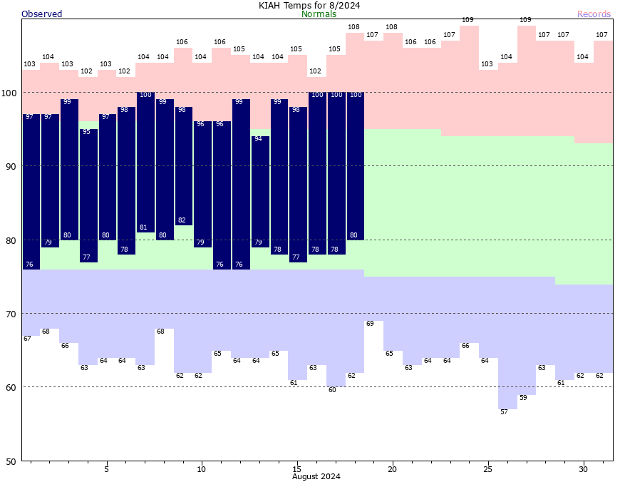
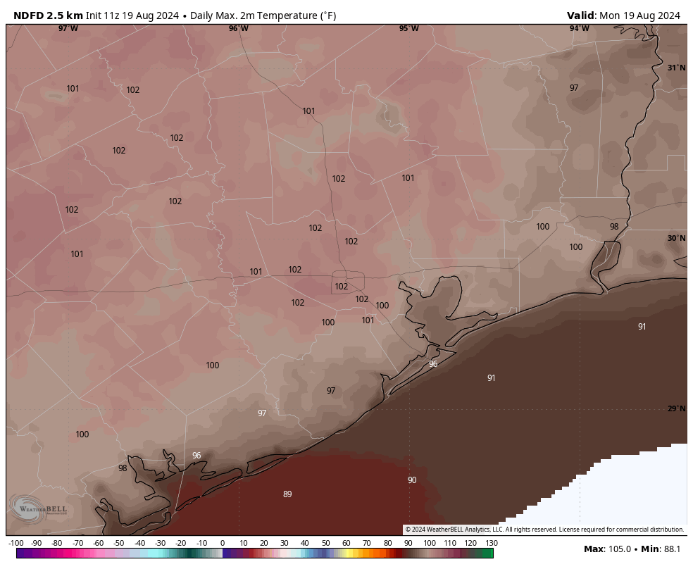
We’re a little more than half way through August, and so far this month we’ve experienced four 100-degree days, and the lowest daytime high has been 94 degrees. Skies have been almost universally sunny, and many areas have experienced no rain. This is how it often goes in August, and our high temperatures for the next couple of days could be even hotter—many inland locations will reach the low 100s today and Tuesday.
However, over the course of this week we’ll see high pressure that has been anchored over West Texas begin to slide northward, and this will begin to ease the peak-summertime weather in Houston. High temperatures by this weekend should fall back into the mid-90s, and rain chances will start to improve this weekend or into next week. The details of all this are still somewhat in flux, but it’s likely that the end of August will feel different than the rest of the month.
Monday and Tuesday
There’s no way to sugarcoat this part of the forecast. With high pressure in place, today will see excessive heat with high temperatures in the low 100s for much of the region. These may well be the hottest days of this year, so please take heat precautions during the middle of the day. Skies will be mostly sunny with very light winds. There will be about a 10 percent chance of rain, as a few isolated showers may develop along the sea breeze. But mostly, these will be very, very hot days. Overnight lows will only drop to around 80 degrees.
Wednesday, Thursday, and Friday
These will also be hot days, but we may trend downward just a bit from the low 100s on Wednesday to upper 90s by Friday. Each day will also see a slightly better chance of rain, perhaps 20 percent, as there’s a little bit more activity due to increased moisture levels. Still, the overall pattern will be one of heat and sunshine.
Saturday, Sunday, and beyond
As high pressure eases off, I think most of the Houston metro area will see high temperatures dip back into the mid-90s this weekend. At the same time we may start to see the influence of low pressure from the Gulf of Mexico. I don’t know if rain chances will improve a whole lot this weekend, but at some point in the next week or 10 days, we’re likely to start seeing much better daily odds for rainfall. So for Saturday and Sunday I’ll say there probably will be some scattered showers and thunderstorms, with better chances for more coverage into next week.
Tropics
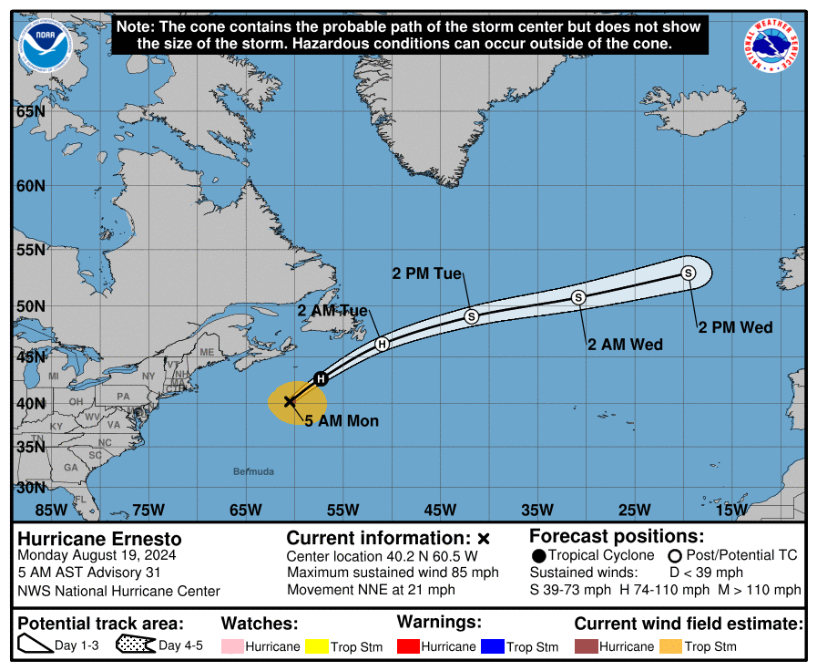
Hurricane Ernesto is in the northern Atlantic, and will pass not all that far south of Newfoundland today and tonight before it accelerates eastward across the open Atlantic. Beyond Ernesto, the tropics look to remain quiet for at least the next week.

😂 Please do what you can to “keep the tropics for at least another week,” the longer, the better. 😂 Don’t want it to “get tropical” while out of town. Thanks!
In the Space City in the year 2024
A rare super blue moon will rise.
Four days hence in the third week
The summer will end and the mercury will peak.
It’s not a blue moon. Blue moons are the second full moon in the same calendar month. This can only happen when the full moons cycle back to the first day or so of each month. Even the news channels were calling this a super blue moon. Sad.
Give the guy a break, he wrote that quatrain like 500 years ago…
NASA says it is called a seasonal blue moon which means it is the third full moon in a season that will have four.
Keith, this is the 13th full moon within a calendar year, so yes, it’s called a Blue Moon. This type of Blue Moon happens about every 2.5 years. Almanac time.
We all know August is the hottest month of the year but could you also mention the other factors that play a big roll in temp make up , eg humidity and dew points and their effects especially for this time of the year. Thanks!
SCW did a good post explaining this back in August 2016 but I will summarize here. The reason it is typically hotter in August is because the Gulf of Mexico is significantly warmer by then. Ocean water takes alot longer to heat up than land. The warmer gulf helps to boost temperatures and dew point levels. Hot water evaporates more water vapor into the air which is why it feels so sticky and miserable during the summer. The subtropical high tends to be strongest over us during August as well. This dries the ground out which also causes temperatures over land to go up. It is sort of a snowball effect.
If there was no ocean nearby to moderate our temperatures than it would get much hotter in May, June, and July than it does now. I’m not completely sure why high pressure is generally strongest in August but some years it can be the opposite. I’ve seen rainy low pressure dominated weather patterns in August before but that is not the norm.
Depends on where you live. I grew up in the Industrial Midwest. Our hottest month was July.
That is very true. Also the far northern states usually start cooling off significantly by late August.
Yes! In the Puget Sound area, the pace of shortening daylight hours quickened and, thusly, the color changes began in earnest near this time of year. Days generally would still be warm, for that area, but in all but the strongest of E-W cross-Cascades airflow, the nights were wonderful. Best time of year for camping and backpacking.
Is there some kind of graphic that shows the path of the storm that became Ernesto? I would like to see how much it boomeranged from beginning to current predicted track.
zoom dot earth has a good past track of Ernesto. I like that site.
I’ll take this over a TC anyday.
A reader commented last week that happy song lyrics often include the words “sunny days”. I thought this comment was poignant. As in the Houston area, most of us I think dread sunny blue skies except in January and February.
I think this would be a good time to play Cold Front Lotto! Participants could guess the date and time of the “first “ official cold front at Bush Airport for some SCW swag.
Define “cold”.
Today’s wet bulb temperature will be about 77 degrees at 6PM, and there will be a slight breeze (5 to 6 mph). Things could be worse. Sweat will be dripping, and skin will be salty.
Was it just me, or did this morning not feel too bad? Felt drier and the light breeze felt “good”. (relative, of course)
It wasn’t just you. I was outside watering and enjoyed the breeze out of the north. Seemed a bit different (in a good way).
I started out about an hour later than normal on my walk, about 07:50..I put in 11,500 steps in, and finished, back to my car by 09:40…To me the morning was gorgeous, and I had a better experience than usual for starting out at this time of morning, this time of year..I was hot and sweaty, yes, but at the same time my walk was pleasant!
Pattern change = Brutally hot —-> Not quite as brutally hot.
Just eagerly anticipating THE END of all the RIDICULOUS multi daily push alerts from the local 3 about Ernesto… I truly believe we’re “in the clear now”, so please STOP!
we need dome of high pressure through end of September keep them hurricanes away