In brief: Houston has a really nice weekend ahead of us with 70s and sunshine. Next week gets a little trickier with a storm system Tuesday that could deliver some strong storms, followed by another round of very nice weather.
As the Houston Livestock Show & Rodeo kicks off with the BBQ cookoff this weekend and the parade tomorrow and Mardi Gras rolls on in Galveston, southeast Texas will be treated to some really solid spring weather. But we will be watching next Tuesday for the potential of some stronger thunderstorms.

Today through Sunday
All three days should be partly to mostly sunny with highs in the 70s today, near 80 tomorrow, and back in the 70s on Sunday behind a weak little backdoor front coming from Louisiana. Morning lows will be in the 50s or upper-40s in spots. There may be some fog around tomorrow morning, and there is a chance of some fog clinging to the coast tomorrow afternoon. For Mardi Gras in Galveston, bring a hoodie. If you’re going to pre-Rodeo events or scoping out the Dynamo (and Messi) this weekend or anything else, it’s going to be great.
Monday
Much stronger onshore flow begins to establish on Monday, leading to warmer temps, higher humidity, clouds, and some patchy fog. A few isolated showers or pockets of drizzle cannot be ruled out. After morning lows near 60, daytime highs will probably push to near 80 degrees.
Tuesday
Tuesday is going to be an interesting day. There is a very clear-cut severe weather risk Tuesday as a disturbance and front approach. The question locally is whether the “cap” can break.
For those new to Houston or that aren’t familiar, often during springtime severe weather events, Houston’s geography allows it to be somewhat protected by what we call a “cap” in the atmosphere. It’s just a point above our heads where the air turns warmer and drier all of a sudden, which physically essentially “caps” how tall clouds (and thus thunderstorms) can grow to be. Houston often avoids the fate of the rest of the southern Plains’s reputation for being tornado alley in spring because of this.
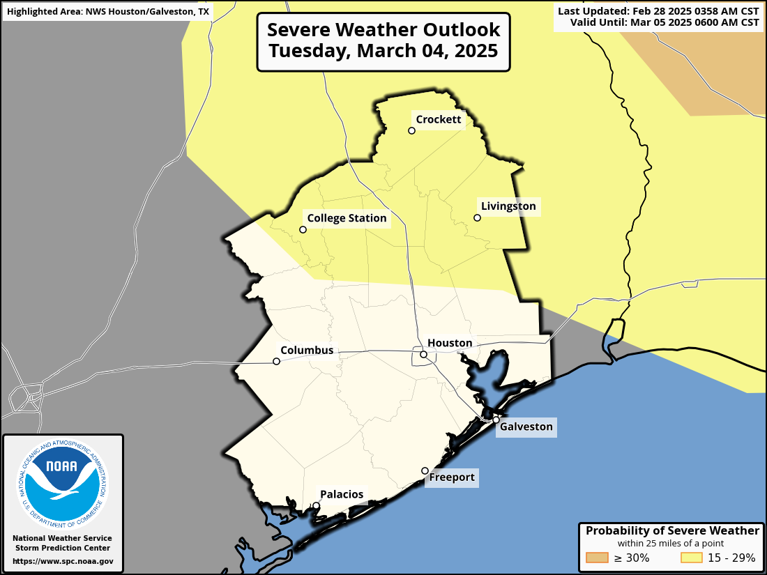
The challenge for us, especially 5 days out, is determining whether or not that “cap” will be eroded or break. And that’s just not really a high-confidence parameter to predict. That said, the highest risk for severe storms on Tuesday will clearly be to our north. But the risk of some strong to severe storms close to the Houston area, especially on the north side of I-10 is not zero.
Otherwise, Tuesday looks breezy and warm, with highs around 80 degrees.
Rest of next week
Behind Tuesday night’s front, the rain and storm threat will end and much cooler, drier air will push back into the area. It looks like a wonderful finish to next week. High temperatures on Wednesday and Thursday will probably be near 70 with morning lows in the 40s and 50s.

What do you say to the storm chaser Reed Timmer hyping up some major weather thr week after next? He was talking about tornados!
Sounds like irresponsible fear-mongering or someone trying to gen up engagement for their channel. Any competent met would tell you forecasts that far out are useless and the results are effectively random. Maybe stop listening to hype and fear.
That’s what I was thinking. I just got off a call where regular folks were monitoring weather in the area because we will be having an outdoor event, and they said it’s looking great! So it was a little shocking to see him come out with this “OMG, Get the truck ready paw!” sort of post.
Reed is a smart dude, no doubt, but he makes his living piloting the hype train and he is one of the first to start blowing up any kind of trough that looks to make its way through the Plains states this time of year.
I can’t comment abour your Timmer person, but I am, at this moment, watching Fox Weather Channel (it’s a 24 hour weather station, over the air or streaming). It’s not a Houston specific station, but nationwide.
They are currently discussing how March is known for severe weather and a very active tornado month. They even show a historical US map for March tornados, and Texas leads the US for most tornadoes in March. Texas averages 15 in March.
They are also discussing “Severe storms kick off March”, discussing the arrival about Tuesday, with most severe cases in Arkansas and Mississippi. They spend 20-something minutes discussing the “why’s” for this unique March activity.
How will the downsizing of NOAA effect your ability to create accurate forecasting especially in the upcoming hurricane season?
Reed Timmer is a storm chasing adrenaline junky. I don’t think he is fear mongering to create hype. He relies on hits from footage not forecasts. I think he is just point out the model forecast.
Exactly.
Zero trust for hypists. It’s not even about the wx, it’s about the mongering fear state. Whatever form they can get.
The attn and fear are like an addiction.
March 14 still clear – not impacted by modeled weather lows on 4th, 8, 12 in the long range – give or take. Yes I know accuracy is very low 2 weeks out but the string above caused me to double take. The program has apparently modeled some correlations to determine this spring pattern outlook. Very interesting little experiment in verification.
I’m already seeing articles about another stratospheric warming event that could lead to another polar vortex breakdown event across North America in mid-March. It could be hype, but they haven’t been wrong about that yet this winter.
Yea, it was rumored about it out here:
Mark
February 20, 2025 at 9:54 am
There is a stratwarm and another stretching of the polar vortex predicted for March so I would hold off on any last freeze predictions.
—- end quote
There’s an old article at apnews dot com titled “Arctic blast cold icy greenland climate polar vortex”, with a paragraph:
Computer forecast models say that the polar vortex is likely to stretch again, sending cold air south somewhere and probably to the United States, around March 5, Cohen said. This is quite late for a polar vortex stretching, Cohen said, but “this season everything seems very unusual.”
— end quote
Funny how they wrote “sending cold air south somewhere and probably to the US” … seems they had no idea where it’s heading. And a bad prediction for Mar 5.
Do you anticipate any impacts from the layoffs that happened with the NWS?
An interesting discussion of that last night can be found on Daniel Swain’s YouTube channel Weather West.
That chilled my blood.
Those poor folks and their families. Those that were canned, those left to clean up after the carnage, and all the coming fallout.
This hurts everybody. I hope NOAA/NWS can still function.
Is the ECMWF independent on NOAA’s data?
I know the GFS is now going to be compromised, but maybe the ECMWF can still operate while NOAA tries its best to reorganize?
*independent if
So… Okay to go to the rodeo Tuesday or no? Should we go Wednesday instead?
As of Saturday’s forecast by the Weather Channel, the rain chances at NRG STadium and Bush Airport should end at 12 Noon, Tuesday. It should be alright to go to the rodeo.