In brief: Houston has no weather concerns today, and most of Thursday should be fine. But beginning Thursday evening, and during the overnight hours, the region faces the threat of heavy rainfall. But for now, it’s only a threat, as our overall confidence is low. We’ve put a Stage 1 flood alert in place for areas along and south of Interstate 10.
Wednesday
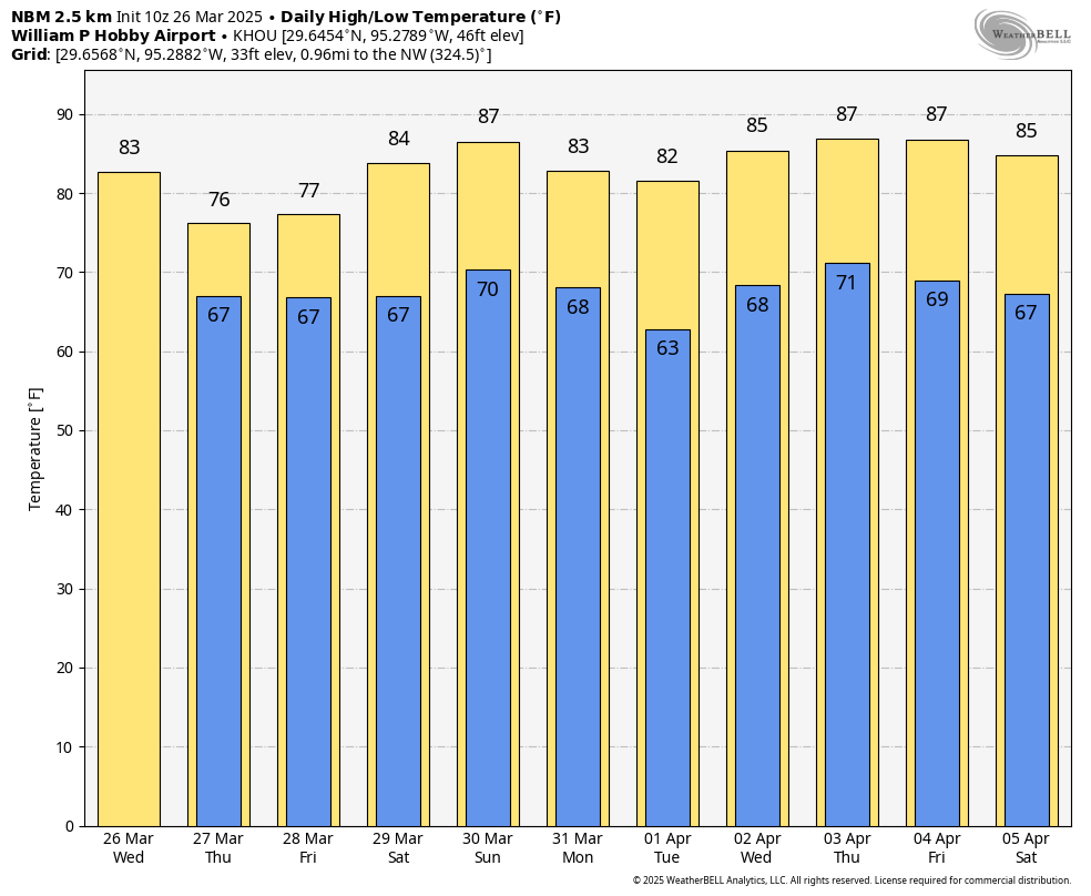
Houston’s high temperature reached 89 degrees on Tuesday at Bush Intercontinental Airport, the city’s official measuring station. Because there will be more clouds today, highs will likely top out in the mid-80s, but with dewpoints in the low 60s it will feel more humid outside. Winds will generally be light, from the southeast. The humidity party continues tonight, when lows will only drop into the upper 60s for most locations. There will also be a slight chance of some rain showers after midnight.
Thursday and Friday
I’d love to provide you with some concrete answers about what to expect with the potential for heavy rainfall to end the work week, but they’re in short supply. Here’s what we do know. Most of Thursday, in Houston, should be fine. If there is heavy rainfall during the daytime, it likely will occur to the southwest of Houston, closer to Matagorda Bay than Houston and its suburbs.
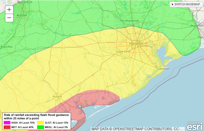
Beginning Thursday evening, and lasting through Friday afternoon, the environment over Houston will become more favorable for heavy rainfall with an atmospheric disturbance and plenty of moisture to work with. But does that mean you’re going to get 4 inches of rain on top of your house? No, it does not. Much of our guidance continues to indicate that the heaviest rains will fall to the west or, more likely, southwest of the Houston region.
We are just now coming into the forecasting range of higher-resolution weather models. These are trending much drier than the global models (which have shown a few inches of rain over the Houston metro area on Thursday night and Friday). By contrast, the higher resolution models are much spottier in terms of showers and accumulations. So which is correct? Well, normally in such situations I would side with the higher-resolution models, but they absolutely missed on Sunday night’s storms that moved through Houston.
The bottom line is that the region faces the potential for heavy rainfall to end the week, but the bust factor is high. Yesterday I called for a total of 1 to 4 inches of rainfall across Houston, and I think that’s still a good forecast range. This type of rain would be enough to cause some street flooding, but not much more. We will continue to watch things closely for you.
Saturday and Sunday
We remain pretty confident that any rain showers, such as they are, should end Friday night or early Saturday. This should leave us with a couple of warmer, at least partly sunny weekend days. Look for highs in the mid-80s with plenty of humidity. Some of the more intrepid among you might try to take that first dip in the pool, even. That’s because nighttime temperatures won’t provide much cooling, dropping only to around 70 degrees.
Next week
Do you like the warmer temperatures and humidity? Well, you’re in luck. After Monday and Tuesday, when a weak front may briefly bring some drier air, most of next week should bring days in the mid- to upper-80s with plenty of humidity. Perhaps we’ll see a stronger front by the following weekend. We’ll see.

I fully expect to just get a quarter of an inch in my yard.
Upper 80s with lows in the 70s in early April is utterly disgusting! That is supposed to be mid to late May weather. Man our climate has really gone off the deep end.
these temps are diabolical for march-april. SMH
Just returned from Aransas National Wildlife Refuge. They are getting desperate for some rain. The Park Ranger told us most of the marshes are dry, and they are really getting worried. Hopefully some of this may get further south?
Might check the weather forecasts again.
The area from Corpus to Matagorda is the center of attention for the upcoming rain storms. That area is in the highest risk zone with predictions of 7-10 inches of rain.
Despite us needing the rain, man, the humidity can shuttle right off, thanks. Bleughhhhhhhhhh
Anymore, I take the rain probability I see on Ch13 and divide by 3, then take the NWS forecast amount and divide by two and then subtract an inch, but not less than zero. Seems to be a good method last year or two.
Facts!
If I’m not mistaken, aren’t we supposed to still get cold fronts this time of year? It seems way to early to already see temperatures so high.
It’s called global warming. Those who say this is normal are in complete denial or they remember one or two fluke years 30 plus years ago. Abnormally warm is the new normal now not the exception like it used to be.
According to NASA, global temperatures have risen a total of 1.9º F since 1880. The climate change people need to get a new script.
Pretty typical that y’all science deniers suck at math and don’t understand averages, too. You’re not only selectively quoting NASA’s page—you’re fundamentally misunderstanding it, too. Did they not teach basic math in whatever backwater you came from?
Yeah for the whole planet, that is a very large difference. That means some specific regions have warmed significantly more than that including Texas. This means more and longer deadly heatwaves and droughts that are in fact happening. It isn’t fear mongering if the issue people are talking about is true.
Long range view…hell’s ridge sets up after Friday. Next cold front is maybe a dice throw April 11 there abouts. Eric nailed the splash on Sunday…from 10 days out! If he says there’s something April 5 weekend I’ll take his word….but I don’t see it. I absolutely adore Houston weather even if it is warming. If you waited for the rodeo to leave town your tomatoes are toast once again. Lol.
Hey @DJ … you wrote: “If he says there’s something April 5 weekend I’ll take his word”.
“what” is supposed to happen? (I might still be half asleep and missed it). I will be at the Pin Oak Charity Horse Show April 5th and 6th, so curious.
At the tail end Eric wrote “….most of next week should bring days in the mid- to upper-80s with plenty of humidity. Perhaps we’ll see a stronger front by the following weekend. We’ll see”
Good luck – I guess we’ll see…there’s nothing on the freebie GPS maybe he’s got a subscription
Is wind supposed to be an issue with these storms, or is it just heavy rain?
If I remember correctly, CSU’s first predictions for the 2025 hurricane season was average. Sounds right.
Then today I see Accuwhether has put out all kinds of hurricane scaremongering already – I didn’t think they could sink much lower, but they managed it. More trust erosion.
Sure am glad for SCW.
I would like to know what people do differently based on the pre-season hurricane predictions. They don’t seem useful. So why worry or care? Tell me when one is going to hit my house. Also note that the trade westerlies are dying down as we move into ENSO neutral. Less wind shear in the Atlantic = more stable cyclones.
Correction: trade winds are easterlies they blow westward
Less wind shear plus high SSTs also means more CAG hurricanes.
The only thing I know to do is stay permanently ready to leave. Those CAG hurricanes seemed very capricious last year.
And like Matt said on the Eyewall, with missing radiosonde data, the path of the eye could easily be off by 75 miles.
I am also concerned that we’ll face an RI hurricane and they won’t know how strong it will be bc of the data gaps. They’ll only be able to guess (I guess).
What a damn nightmare. Evacuating is a nightmare & staying is a nightmare when you won’t know what’s on you till it’s on you. Will they even be able to tell us when one will hit our houses? 🎲 🎲
Here’s my thoughts: No one predicted Beryl cat 1 in Houston except the Canadian icon model. That was pre NOAA cuts. Ike was 2008. Harvey 2017 was a rain event. I’d say by law of averages we’re done for awhile. So folks should relax. Have a plan. A few less balloons is fine. There were 80,000 throwaway balloon launches last year. I’d spend my time thinking about new kinds of weather from fast warming. Like straight-line wind out of no where. For that you need good radar tech. But it’s much safer here than further north where the cold fronts can actually converge on gulf flow.