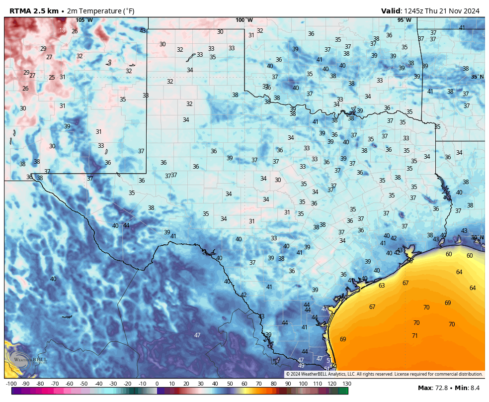
In brief: Houston is experiencing its coldest night of the fall season so far, with temperatures dropping into the mid-30s in some inland locations. We’ll continue to see fall-like weather into Saturday before we warm up for a few days. If you’re wondering about the Thanksgiving forecast, it’s about as clear as plum pudding.
Plans for next year
As we continue our annual fundraiser (you can click here to find more information on how to donate, or buy merchandise), I wanted to talk a little bit about our plans for next year on Space City Weather. Here are some of our goals for 2025:
- Update our flood scale with the latest social science research
- Major overhaul of our iOS and Android apps to modernize their back end
- Big, public celebration of our 10th anniversary
- Additional partnerships with the community to support worthwhile projects

Thursday
Temperatures this morning range from the mid-30s in Montgomery County to the upper 50s on Galveston Island, which gives you some sense of the geographic diversity of the Houston region, and the challenge of forecasting weather across such a broad and diverse area. In any case, it’s the coldest night of the season so far, and you’ll probably want a sweater or jacket on the way out the door.
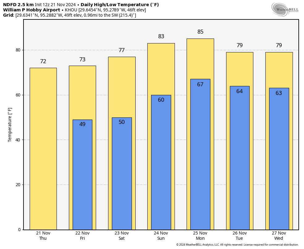
High temperatures today will reach about 70 degrees beneath sunny skies. Winds will be light from the north or northwest today. With dewpoints in the 20s this afternoon, the air will feel very, very dry for Houston. Temperatures tonight will be chilly again, but likely 1 to 3 degrees warmer than Wednesday night.
Friday
A day that will be a lot like Thursday, with ample sunshine and drier air. High temperatures will be a touch warmer, in the low 70s, with overnight lows dropping to around 50 degrees in Houston, with cooler temperatures for outlying areas.
Saturday and Sunday
As high pressure makes its way to the exits, we’ll see the onshore flow returning this weekend. Highs on Saturday will still hold in the mid-70s for most locations, with mostly sunny skies, and fairly low humidity. But overnight temperatures will only drop to about 60 degrees. The second half of the weekend will see the return of some clouds, a bit more humidity, and high temperatures in the lower 80s. The weekend looks rain-free, so any activities you have planned are good to go.

Next week
Trying to forecast the weather for next week really ruffles my feathers. That’s right, you’re going to get plenty of Thanksgiving puns right up to the holiday itself.
Monday looks warm, with highs in the mid-80s and a warm night. At that point a weak front may sag into the area—we’ll see if it has enough oomph to push all the way through—and this could knock temperatures back slightly on Tuesday.
A stronger front is probably coming later in the week, but whether that’s on Wednesday night, Thursday, or Thursday night is not something we can say for sure. And with the Thanksgiving holiday on Thursday, the timing really matters, especially since there is likely to be a little rain with the front. In any case, I’d expect daily highs to be around 80 degrees ahead of the front, and likely falling back to the 60s afterward. So yeah there’s a wide range of possibilities still on the table for Thanksgiving. Next weekend should be colder, however, with nights in the 40s or 50s.

Mid 80’s! Another 50 degree swing. Geez Louise. How is that even possible close to December and with such a low sun angle.
Idk for sure but I’m suspecting the winds will shift in a southwesterly direction on Monday. That usually gives us a mix of warm humid Gulf air and dry warm West Texas air. This can reduce cloud cover allowing our temperatures to rise higher during the afternoon. This wind pattern has been responsible for many of our record highs during the winter like in 1986 when Houston had its earliest 90 degree day on February 20th. Houston also hit 90 on February 22nd 1996 because of the same wind pattern.
Even if the angle of the sun is low it can still warm up alot if given the appropriate airmass. We are also living in a warming world so the air from the south is warmer on average than it used to be. Just last week the water temperatures in the Gulf near Florida were 90 degrees in November! So with a much warmer Gulf and warmer desert southwest, we have no choice but to see much warmer than normal temperatures once the cool Canadian airmasses retreat and the southerly flow returns to Texas.
The heat content of water from that sauna sitting off the coast. It just sits there, waiting to usher in miserable air when the flow is just right. Bahh, humbug!
It’s 36°F Humidity 83F and Dew 33° out here in Magnolia (that was at 6.10am). We anticipated slicing our morning walk into two, the last 1/2, an hour later. But there was zero wind, so we did the entire walk.
CPO shirt, sweatpants, and home-knitted cap were just right. Tomorrow morn is supposed to be a close repeat. Might call the VA clinic to see if they have any keep-warm pills 🙂
Another goal for 2025 should be (continued, credit where credit is due) unbiased reporting of the weather-related collapse of the power infrastructure.
Where are highs in the 50s or 60s.
It has been non existent this season so far.
I love your holiday puns; they are a good way to start my morning. Thank you for giving me the weather news I can depend on.
using a baseball analogy, these cold fronts have been singles and doubles. No home runs yet. And in some cases complete swing and misses (they dont reach us). It seems like every anticipated cold front turns out 5-10 degrees warmer than anticpated.
Its mind boggling how this warm air continues to stick around and wont move.
I was quite surprised. I didn’t think we would drop into the 30s this November. We have had Novembers in the past where we didn’t drop below 40 degrees, and I figured this November surly would have been one of them the way its been.
36.9 F and 99% RH at my home in Sienna at 7:00 am this morning. At 1:00 pm it is 70 F and 28% RH.