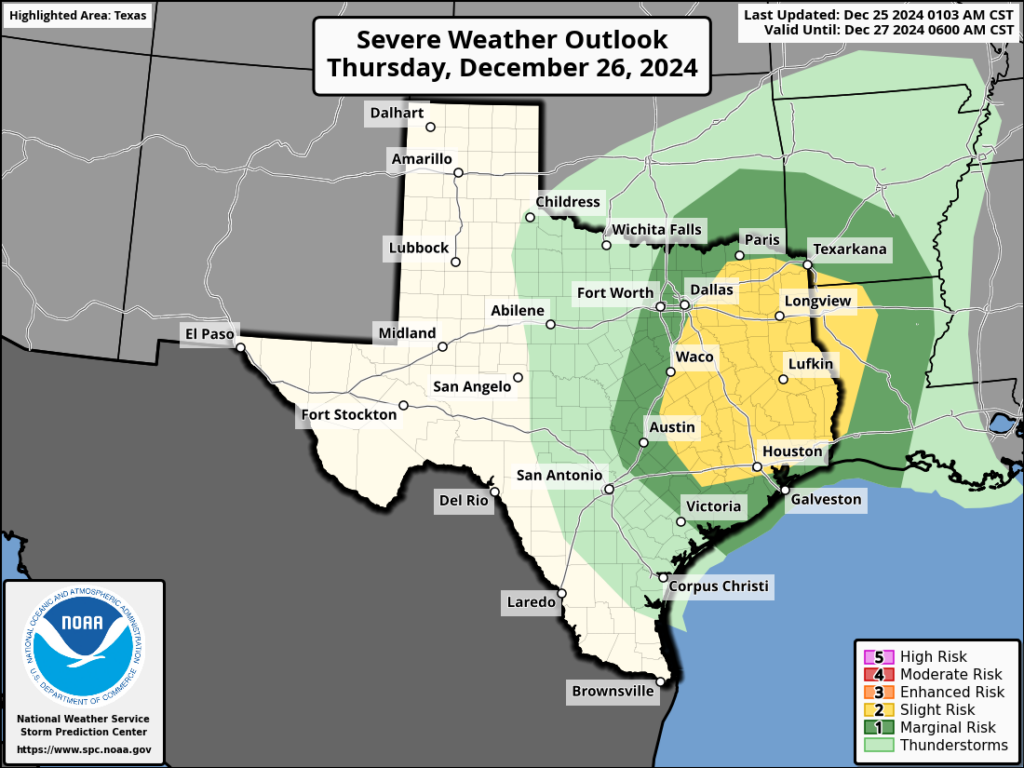
In brief: Good morning on this fine Christmas Day. Santa sure brought the thunder last night, didn’t he? We are interrupting your holiday with a short update to note that another round of storms is possible Thursday as we see a similar setup: Lots of moisture in the atmosphere and a weak frontal boundary.
Christmas Day
The storms have cleared our area to the east, and we’ll see a calm day today. Look for high temperatures around 70 degrees, with partly to mostly cloudy skies, and possibly a few light, lingering showers. Tonight will be mild, with lows in the lower 60s. The bottom line is that, soggy soils aside, any activities today and this evening should be fine.

Thursday
As atmospheric moisture levels rise, we’ll see the possibility of some fog on Thursday morning to go along with some fairly humid conditions. The problem is that we’re going to see another disturbance propagate down from the northwest during the daytime. What this likely means is that the Houston region (particularly coastal areas, maybe?) will see the potential for some scattered showers and thunderstorms.
Then, later on Thursday afternoon or early evening, we’ll see a line of storms move down from the northwest to southeast. I’m not convinced these storms will be as organized as what we saw early on Christmas morning, but there’s the potential for some damaging winds, more hail, and briefly heavy rainfall. They might also strike during rush hour. The storms should clear the area before midnight.
Afterward, Friday and the weekend looks pretty pleasant. We’ll have all the details on that in our forecast on Thursday morning. Until that time, have a wonderful holiday!

Any concerns about the tornado threat for Houston, or is it more Piney Woods focused? Weather peeps on X seem to be pretty animated about it.
Per the Weather Channel, there is no concerns of a tornado threat in Houston at this time.
Thanks for the heads up for those of us that go back to work tomorrow morning! Have a great holiday
1-3/4″ rain overnight, a Christmas present. 🙂
3 1/4″ down south!
“Set up for Thursday is similar to Tuesday with a deepening mid level disturbance currently over Utah moving across the area on Thursday with a focused 30-40kt low level jet and increasing moisture and instability. Any breaks in the overcast will only help to destabilize the air mass ahead of the primary lift during the afternoon and evening hours. Expect scattered showers and thunderstorms to develop in the morning hours and expand in coverage and intensity through the day. Similar to Tuesday discrete cells in the open warm sector will have a related severe weather risk of large hail and damaging winds however progged sounding show a bit more low level turning in the atmosphere on Thursday which may support a slightly greater tornado threat.”
No more tornados no more tornados no more tornados
Please ⚘⚘⚘
I can vouch for the rain – got caught in a downpour on the morning walk just after I passed maximum distance from the house.
Merry Christmas everyone.
I got 1.5 inches of rain in my backyard last night. The ground absorbed it like a sponge with how dry it’s been. Even during the winter the ground will soak in water fast when it’s dry.
Loved the overnight weather, accurately forecasted by SCW. Nice gift of lightning and rain. Some blue sky and sunshine Christmas morning has made for a bright uplifting day. Our best to you and your team!
The weather side of Pearland is in the pocket of a ton of rain. It seems to have finally stopped, so hopefully my turkey on the smoker gets done on time
Happy Holidays to you both and your families! And congratulations on being named Houstonia Magazine’s
Houstonians of the Year!
Well deserved!
Roads were flooded near me and I couldn’t get home from work Christmas eve. So odd that wasn’t wide spread. If it’s going to be a repeat I think I will call in
Merry Christmas!
Luke 2