In brief: Monday’s showers were hit or miss, with a few areas picking up 2 inches of rain and much of the rest of the area seeing dark clouds but little precipitation. This stormy pattern will continue for two more days before we turn sunny and hot for the second half of the week. Rain chances look to increase again early next week with the influx of tropical moisture. In today’s post, we also share a weather oddity observed on Monday.
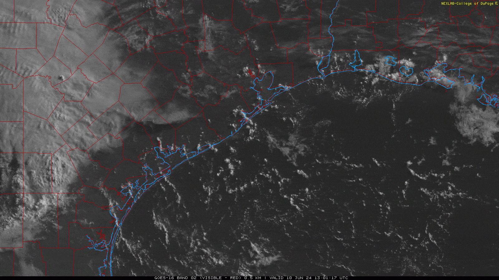
Clouds over Houston’s freeways
On Monday a reader, Chris Yetsko, noticed an interesting feature when he was looking at satellite images of the Houston area shortly after sunrise. If you look closely near downtown you can see lines of cumulus clouds briefly firing up to the north. These align with Interstate 45, Highway 59, and Highway 290, just at rush hour. Frankly, neither Matt nor I have ever seen anything like this.
So what’s happening? I can’t say for sure. Cumulus clouds like these form when warm, humid air rises rapidly. When this air encounters colder temperatures aloft, water vapor in the air condenses. We did see some slightly cooler air north of Houston on Monday, so this may be why we see this phenomenon on freeways north of downtown, rather than south of the city where the atmosphere was a little warmer. Freeways, of course, are warmer than surrounding areas due to automobile exhaust. In any case, a fun little meteorological mystery we wanted to share.
Tuesday
The overall setup today is similar to Monday, with plenty of moisture in the atmosphere and a series of disturbances propagating through the area. Therefore, I expect we’ll see the development of fairly widespread showers and thunderstorms later today, predominantly during the afternoon and early evening hours with daytime heating. Accumulations should again vary widely, with some areas perhaps picking up 2 inches or more, and many areas seeing little measurable rainfall. Brief street flooding is possible under the strongest storms. Otherwise, expect partly sunny conditions today with high temperatures in the low 90s.
Wednesday
This should be a similar day to Tuesday, albeit with perhaps less shower and storm coverage during the afternoon and evening hours. Expect highs in the low 90s.
Thursday and Friday
Rain chances don’t entirely go away on Thursday, but they’re probably going to drop into the vicinity of 10 percent. By Friday they should be gone entirely. Thus, I expect these to be mostly sunny days with highs in the mid-90s. The humidity will be slightly lower, so enjoy those mornings and evenings.
Saturday and Sunday
The first half of the weekend should bring more hot and sunny weather, with most of the area in the mid-90s. However, we can’t rule out a few areas popping into the upper 90s. By Sunday the high pressure ridge that will bring sunny conditions during the second half of this week should be easing off, and it will open us back up to some rain chances. I’ll ballpark them at 30 percent or so, but we’ll need to fine-tune that as we get closer.
Next week
We’re still looking at the possibility of an influx of moisture from a tropical system in the Gulf of Mexico starting on Monday. The forecast is pretty messy, meaning there are a lot of variables in play and the models are struggling to hone in on a solution. My sense is to not be too worried about this. I’m just not seeing much of a signal for a really organized tropical storm to develop in the Southern Gulf of Mexico next week. The primary threat is heavy rainfall, but again all we can really say at this point is that we may see some elevated rain chances next week. We’ll keep watching for you.

As a professional pilot I have been a practicing meteorologist for many years
I have seen micro climate development in the Rocky Mountains also flying my whole career from Houston I have seen the concrete develop micro climates
Flying over the N Atlantic I have seen the retracting glaciers in Greenland
I believe our development cause small localized changes in our weather that are man made however I believe climate change globally is a natural occurrence
The recent cumulus clouds along the freeways I have seen many times in the last 50 years
What I haven’t seen is the number of Thunderstorms in this area with tops reaching to over 60,000 ft a few at 66,000 ft this spring
Except when flying close to the equator
Keep up the great work always enjoy y’all’s analysis
Please … do use a red market or some sort of highlighter to enlighten the rest of us as to the egregious misuse, or lack thereof, of proper punctuation in this informal information-disseminating article intended for the general population of perhaps non-English-degreed masses. Thank you.
Marker*
Not sure if the imagery is visible or IR or something else, but could it have been caused by the rising sun hitting the highly reflective cars on the highway and increasing the visibility of the clouds above them? Essentially causing the clouds to be backlit and show up as brighter to the satellite’s optics?
I know we have our spring and summer thunderstorms, but last night was another nasty downpour. I don’t recall our thunderstorms having this much strong wind associated with them in the past; maybe I’m just more aware after the derecho. Am I on to something or is it a figment of my imagination?
It was refreshing to get a good soaking inside the Loop near sunset to help cool down the soil and buildings. And, the cloud buildup was a nice shield to the evening sun (again blunting more radiant heat).
Looking forward to a repeat this evening but with half the rain.
Water vapor needs condensation nuclei to condense and form clouds. Vehicle exhaust contains particulates which become the condensation nuclei enabling clouds to form. I saw this happen several times while living in the Tampa, FL area as the clouds aligned themselves with the interstate orientation.
Internal Combustion engines also produce water vapor.
So sick of this stupid rain and the power outages with our crappy grid!! The slightest breeze makes the power flicker. Enough is enough.
Sorry, we’ve tried nothing and we’re all out of ideas.
This is TEXAS, where it’s every man (or woman, but mostly man) for himself. We’re each expected to have our own generator instead of being able to rely on a SOCIALIST power grid. Make sure it’s powered by GAS and stand your ground with a GUN.
[heavy sarcasm will go right over most heads]
Let it rain, let it rain, let it rain. Glad to see June looking like a wet month for us.
Still flooded around here from half a month ago and the mosquitos are killer. No more rain.
The freeways are warmer due to the concrete and lack of trees. Vehicle exhaust is insignificant. Concrete drives the urban heat island effect.
Not to mention heating up the rebar inside the concrete. That’s what keeps the concrete hot at night causing the raise in temps for morning lows (as compared to rural areas). Its no rocket science.
I think if we add one more lane everything would be fixed
😆
The heat from exhaust is likely insignificant, but I wonder if the moisture from exhaust had anything to do with it?
So, last night it rained for 35 minutes and the flooding was intense and wide ranging where I am. All streets were rushing rivers… completely impassable. It’s hard to believe that was only 2 inches of rain? Streets remained flooded for over an hour after the rain ended. Remarkable changes.
If it rained 2″ in 35 mins, we had a rainfall rate of about 4″ an hour. Unfortunately our storm drainage system isn’t made to drain such downpours instantly, (because that would be very expensive) however, the streets should drain within that hour for sure, maybe there are blocked drains and inlets in your neighborhood because of street or tree debris? I definitely have had to unblock a drain or two to get the streets back opened up. Hopefully your drainage issues are cleared up soon.
You were getting around 4” an hour rain rate. So about 1” of rain in 15 minutes. People need to learn about hourly rainfall rates. It’s key and important. When you start getting hourly rain rates of 4” an hour it’s gonna flood. 1” in 15 minutes is a tremendous amount of water in that time span.
I have tried to stress this same exact thing to people for years. Everytime my town gets 4 or 5 inches of rain in just a couple of hours, everybody freaks out wondering why the streets and ditches are flooded. They always complain about how there must be something wrong with the drainage in town. No, the drainage is just fine it’s because a torrent of water fell on the ground and streets much faster than it could run off or soak in. Each time we get a flood it drains off pretty quickly everytime. Now yes a clogged culvert or 2 can exacerbate the issue in some spots. It is important to make sure all drains are cleared out as much as possible but that is not going to prevent a flood if to much water falls all at once. Try dumping a full pot of water into your sink all at once. It’s going to pond for a little bit because the drain can’t take all of it immediately. Same concept.
I believe it. In Surfside Beach we talk about the “Dow Bubble” impacting local weather. That bubble would be 1000’s of acres of chem plant industry surrounded by coastal marshland. There are big thermals around that area as evidenced by hawk-like soaring birds hunting surrounding brush on many days.
Weather aimed straight for us will sometimes seemingly be broken up or steered.
Darn it! Those clouds would have gotten away with it if it weren’t for you meddling meteorologists.
My rain gauge was at 3 inches this morning 😊!
Zip code 77005
don’t think the automobile exhaust has much to do it, rather the hot cement roadways and urban development is the more likely cause.
Really enjoy all these climate “ experts” this morning….🙄
Nice catch. If you look WSW…almost along the SW FWY…it looks like the forming Eyewall of a very disorganized Hurricane. Maybe not.
1.38” 1.64 MI SSE KGLS.
We got 4.5″ on Monday night in Montrose near St Thomas University.
2.6 inches in Kingwood yesterday evening
I’d feel more comfortable about any heavy rain event if Juneteenth wasn’t next week. We already have too many major flooding events named after the holidays when they happen.
As a kid growing up in Tampa (the 90s), I noticed that afternoon summer thunderstorms always seemed to pop off right around the I-75 corridor on the gulf sea breeze. I always assumed the strip of asphalt that at that time was mostly surrounded by greenspace created just a bit more convection to focus thunderstorm initiation in that area. These days, the area is much more developed, so I doubt the effect is as prevalent, but I haven’t really lived in Tampa for 20 years now either to confirm if it has changed. Granted, it is purely anecdotal, and maybe something else was at play. I wouldn’t be surprised if freeways create numerous local impacts that we overlook unless we focus on them. I think your explanation is likely on the mark for clouds over the freeway, as it is early morning, and daytime heating wouldn’t have time to create the same phenomena I saw as a kid in the Tampa area.
Not an official rain gauge, but mine in Montrose measured 6″ this morning. 6, to match the number of vehicles towed in front of my house (more towed on W. Alabama and nearby streets). Rain lasted about an hour, which, due to floating debris inevitably blocking storm drains, took forever to drain away. That’s 2 car-towing, garage flooding rain events in 2 weeks for us.
Heat Island effect (ref clouds building over freeways)
quote:
These align with Interstate 45, Highway 59, and Highway 290, just at rush hour. Frankly, neither Matt nor I have ever seen anything like this.
So what’s happening? I can’t say for sure. Cumulus clouds like these form when warm, humid air rises rapidly. When this air encounters colder temperatures aloft, water vapor in the air condenses.
=== end quote
It’s an easy answer: It’s the concrete jungle.
All locations mentioned are nothing but concrete with ZERO provisions for runoff, plain and simple. Nothing meteorological required.
Highways with Zero provisions for runoff? I can re-assure you, they’re one of the places with the best provisions for drainage.
could it have anything to do with the cloud seeding or other experiments at controlling the weather they are doing?
Today has been a good example of what in my memory is how Houston’s summers used to be. Warm and muggy, increasing but scattered cumulus buildup during the day culminating in scattered showers. No wild winds, flooding downpours, very little lightning and thunder. The pattern would repeat day after day, week after week, and the showers would be in different areas of the county so nobody got too much, or too little, precipitation.
No rain here in Magnolia … the rains moved more easterly than predicted. (now mostly over Crosby)
Was hoping for rain.