In brief: Rain has been manageable so far today. We expect more rain this evening, with scattered heavy downpours. Another round of potentially heavier rain is possible on Thursday morning. We’ll maintain our flood alerts as is for now.
Rain has been mostly under control since this morning thankfully. The next wave is coming ashore now at the coast, and even this one is checking in a bit more manageable than it looked this morning.
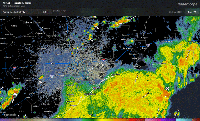
Still, rain rates around 1 inch an hour or so are likely as this pushes ashore. As it moves north and east, we’ll see most rain impacts on the southeast side of Houston, with isolated to scattered downpours north and west. Total rainfall will be an additional inch or two at the coast and less inland (except in isolated heavier downpours) through this evening. Any street flooding is expected to be more nuisance in nature.
Looking ahead, modeling is suggesting another rather beefy area of rain and storms approaches the area overnight or early on Thursday morning. This would be capable of perhaps another 1 to 4 inches of rain.
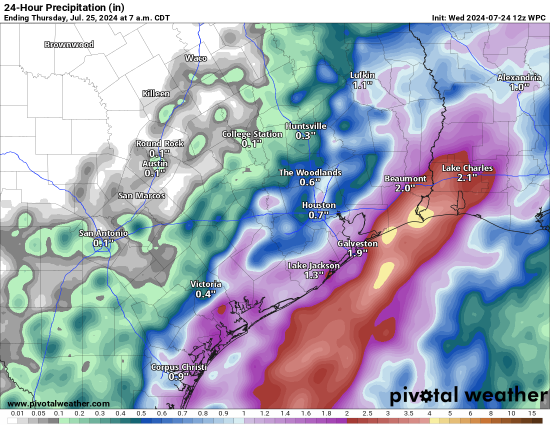
There remains enough uncertainty in the models that we use for these type of rain events that I think maintaining the Stage 2 alert for the coastal areas and Stage 1 inland is the right move. One model we track closely during these events suggests as much as 7 to 10 inches could fall in a worst case scenario between Galveston and Port Arthur and southwest Louisiana. I would especially watch the Beaumont-Port Arthur area in this setup. We don’t expect that outcome, but we can’t rule it out entirely. For the majority of metro Houston and suburbs, another inch or two, with some seeing more and some less seems reasonable.
Eric will update us on Thursday morning with the latest regarding the rainfall.

Today turned out to be a great uneventful day. Models over doing it up to today. Long term downstream models are picking up something early week of August moving towards Florida straits and eventually in gulf. All attention will be starting next week if anything materializes.
And a reminder that long range models are not 100% so if nothing materializes in early August I hope you dont post that the models were wrong again
Every time you say the storms are moving in from the coast, they dissipate. What happened to them? Especially yesterday, I still can’t figure out why they dissipated as they moved inland. Today, it would seem the front has pushed offshore, so it makes more sense. But yesterday afternoon, the front was north of us, yet the rain dissipated as it neared us.
Not seeing much here in The Woodlands.
Dry air. This morning the humidity at my house was only 80%. That’s bone dry for Houston. Granted its a surface reading but I bet it extended well up the column.
Just now (3:40pm) checked the NWS radar. Looks like storms are moving to the east and slightly lower along the coast, versus coming upwards. Of course, it’s south Texas, so could change at any moment 🙂
At the moment, no concern here in Magnolia. And maybe not on Thur (?).
I am supposed to fly out of Bush tomorrow morning. What is the risk for heavy downpours and dramatic thunderstorms in that area?
As of 10pm, Wednesday, according to the Weather Channel, there is a 50 to 60% chance of rain from 4 am to 12 noon at the Hobby Airport area. The total amount of precipitation forecasted is 1.45”, with .3” for 7am to 8am and .3” for 8am to 9am. I hope that helps.
Another channel is saying 5 to 7 inches of rain in Galveston County
This was pointed out by someone else before – but the SCW Flood Alert stage 2 pics should say “e.g. only Katy”, not “i.e. only Katy”. They are currently stating that the isolated impact is always and only to Katy. Maybe that’s why they always think they need to evacuate?
Glad somebody else noticed. Every time I hear these guys quoted as weather geniuses on the radio I think about that graphic.
You’re reading too much into that. The focus on Katy is the result of a long-standing joke about so many people from Katy asking if they need to evacuate for .
Not much rain at our house (Memorial and Kirkwood).
How is it looking in Spring for Friday day/night?