In brief: The first fairly strong front of fall has arrived in Houston, and dewpoints are plummeting this morning. We’ll see a rather cold night, with lows on Thursday morning reaching the upper 40s in parts of Houston. Temperatures start to recover by the weekend, and next week looks rather warm and muggy.
Update on record highs
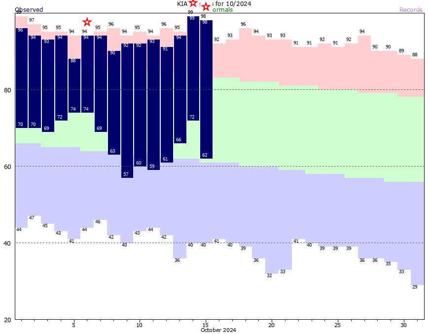
Houston shattered another record high temperature on Tuesday, with a mark of 98 degrees. This broke the previous record of 92 degrees for October 15, set in 2019. Again, breaking a record by six degrees is remarkable, and not in a good way. This was the third record high of the month, after the city tied a previous record back on October 6. The average temperature so far this October is running 5.0 degrees above normal.
Wednesday
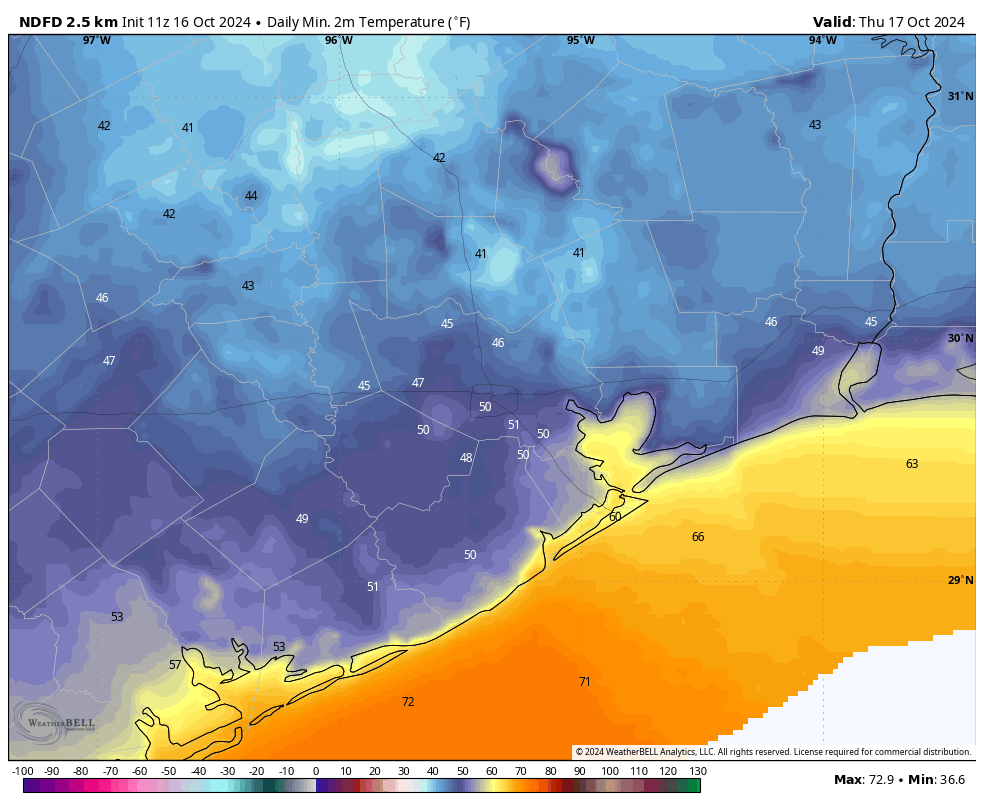
Fortunately, we can put talk of record highs aside for a few days after a front blew into Houston overnight. This was a dry frontal passage so there was no rain accompanying it, and we are now seeing much drier and cooler air moving in. Temperatures this morning are generally in the mid- to upper-60s across Houston, with dewpoints around 40 degrees. Skies will be partly cloudy today, and with the influx of cooler air our highs will probably max out in the low- to mid-70s. Winds from the northeast will be brisk, maxing out at 25 mph or perhaps even a bit higher. Lows tonight will drop to around 50 degrees in central Houston, with cooler conditions for outlying areas.
Thursday
It will, dare I say, feel cold on Thursday morning? With sunny skies we should warm into the mid- to upper-70s however. This will simply be a fine, fall day. Lows on Thursday night should drop into the upper 50s for most locations except the immediate coast.
Friday
Expect mostly sunny weather and highs of around 80 degrees. Winds will be from the east at about 10 mph with higher gusts.
Saturday and Sunday
Expect partly to mostly sunny skies this weekend, with high temperatures generally in the low 80s. With the return of a southerly flow on Friday, humidity levels will be recovering. Nighttime temperatures drop only into the mid-60s.
Next week
Most of next week looks fairly warm and humid. I’d expect highs in the upper 80s, with muggy nights in the upper 60s to 70 degrees. Skies will be partly to possibly even mostly cloudy, but I don’t see much of a chance of rain until at least the latter part of next week. That’s also when we might see another front, but that is far from certain.
The bottom line is that if you’re looking for fall-like weather, soak up the next few days. Because after that it’s going to feel fairly warm and muggy for awhile once again.

Been waiting 6 months for today……..
And, sadly, today and tomorrow are all we get.
back to highs in the upper 90s over the rest of winter I hear.
What about rain. Has October ever been this dry?
Yes we have had 2 rainless Octobers that I can think of off the top of my head. 2010 and 1952.
Not recently. We got 0.02″ in Oct 2010 and 0.14″ in Oct 2016, but typically we get some precip through cold fronts. Bummer that this front was a dry one.
What a flux, 99 to 49!! Happy Fall Day y’all!!!
🍂🍂🧡🍂🍂
Is this October going to cause Matt to reassess whether September is still the “tease” month?
false fall part 2. i don’t believe in the real fall until the day high is in the low 70s.
Any rain chances Eric/Matt? Houston is desperate – the door on my backyard shed won’t open due to the shifting ground from lack of rain.
Sadly I’m getting 2016 vibes this fall. That year on October 21st we had one 2 day cool front with highs in the 70s and lows in the 50s, then it was in the upper 80s every day until the 2nd week of November. I would not be surprised if we had that same scenario happen this fall the way it’s looking.
We were told no more 90 degree days. Doesn’t look to be the case anymore..:
Now we’re getting somewhere.
Summer hater is getting 2016 aches, but I’ll take that over 2010 if that’s how it’s going down. Let’s get our victories when we can.
Our AC systems will get their first day off since late April.
Take heart S. Hater and the rest of us.
Who knows, in 6 weeks we might mess around and have to wrap the pipes, La Niña winters are known for that. Memba 2021??
Yes very true it seems like La Nina winters can sometimes deliver our harshest cold snaps even if the overall winter is warmer than normal. December 2022 and February 2011 are a good example of that. We also had a pretty strong cold snap during January of 2018, which was also a La Nina Winter.
Matt, Eric, any chance we could get a deep dive into what’s happening with the weather in Houston these past few months. It definitely seems like we’ve been stuck in a warm, dry pattern since August. Can we expect to stay in this pattern for the fall and winter? What would it take to break us out of this pattern? I’m sure you both are stretched thin as hurricane season is still winding down, but it would be nice to get a look-ahead forecast for fall/winter/spring, and another one in summer, similar to what you all do for seasonal hurricane estimates. Thank you.
LOL I love your nickname! And I second your request.
My attitude towards the weather is we get what we get, there is absolutely no value whatsoever in expecting or requesting or begging for anything different. I go out in the morning and say to myself: “Okay, this is what it is” and just go about my business.
I’m not Matt or Eric, but from my best observations, we have been stuck under a persistent high pressure ridge since August. So far this October, the upper level high has expanded and is now sitting over Texas and the Western Unites States. This heat ridge is acting like a shield blocking the polar jet stream from being able to shift further to the south our way. So all the cool fall air has been trapped to the north while the hot desert and tropical air has been stuck over Texas. This is a fairly common pattern with La Nina fall/ winters. The jet stream tends to stay north of Texas in an arch like configuration. This keeps us high and dry for long periods of time. We are expected to enter a weak La Nina by the winter but we are already experiencing a mature La Nina pattern this month. Other factors come into play as well not just the ESNO.
The only way this pattern will change is if this upper level high weakens and shifts further to the south. This would allow a trough in the jet stream to send a rain making low our way with much cooler temperatures. This will likely happen as we enter November or December. Because of the Earths tilt the jet stream naturally starts shifting further south during the winter months.
However, during a La Nina winter we usually see the rainy cooler patterns less often which results in us averaging warmer and drier overall. But like I always say, when it comes to the weather flip a coin and that’s what you get.
We’ve been going on our morning walk at 6:45 here in Magnolia, because of the recent heat wave.
Today, we slept in, knowing it will be nice. So, left about 8am. And yea, it was very nice. It’s also nice and breezy, winds about 10+ mph, plus, leaves are falling from the trees. Will do another walk soon.
History: early on October 16 1989, Hurricane Jerry made landfall on Galveston.
False Falls break my heart but I’ll snatch these few meager crumbs and pronounce it excellent.
HAPPY FALL DAY!
Really nice doing morning rounds at the plant today.