In brief: In today’s post we discuss the state of Houston’s winter to date, which is more or less in line with seasonal predictions. We then look at relatively mild weather for the rest of this week, followed by sharply colder conditions on Sunday and the first half of next week.
Winter update
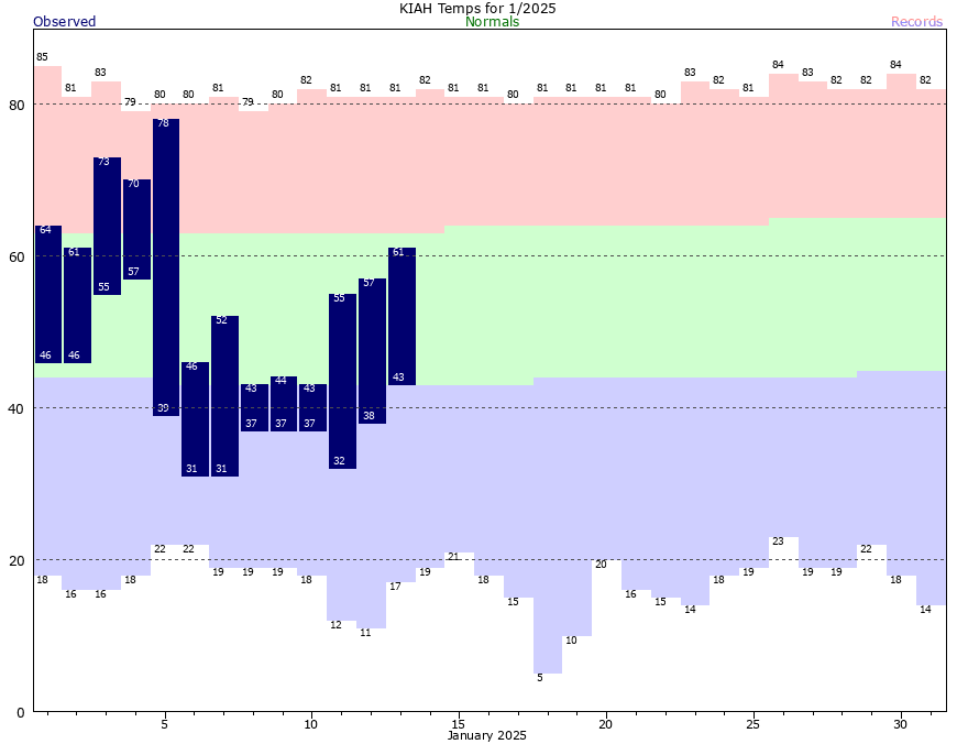
Don’t look know, but if we define winter as December, January, and February—which is as good a time period for winter in Houston as any—we are now just about halfway through. So far, we have had generally warmer than normal temperatures, with the city’s average temperature in December nearly 6 degrees above normal. Last week was significantly colder, but on average we’re still a few degrees above normal so far this winter.
What is “normal?” Generally, in January, we see highs in the low 60s, and overnight lows in the lower 40s. We will be in the vicinity of that for most of this week, although the mercury goes up toward the end of the work week. We might even hit 70 degrees on Friday or possibly Saturday ahead of a strong front.

If you cast your mind back two months ago, when we published our winter outlook, we predicted a warmer than normal winter. But there was a caveat:
Because of the way this pattern sets up, it will block much of the colder Arctic and Canadian air from the lower United States for most of the winter. But that does not exclude the pattern breaking one or two times. If that happens, and it probably will at least once this winter, there will be a large pool of much colder air available to dip down into the southern United States, including Texas.
We had the first of those outbreaks of colder Arctic air during the first 10 days of January. Now, we’re about to get a second one during the last 10 days of the month. At this point, the upcoming period of colder weather looks like it could be sharper than the first one in early January, with a hard freeze possible for much of the Houston metro area. More on this below.
Tuesday
Winds have shifted to come from the northeast overnight, and they’ll shift further to the east today. This will bring with it an increase in atmospheric moisture and the development of more clouds. This will help to limit high temperatures to the mid- to upper-50s today with milder conditions tonight. Lows will drop into the upper 40s.
Wednesday
This will be a fairly grim day. In addition to mostly cloudy skies, a coastal low will help produce a decent chance of rain showers across the southern half of the metro area, with a lower possibility of rain further inland. Expect highs in the lower 50s, so along with leaden skies and the potential for some light showers this will be dreary affair. Lows on Wednesday night drop into the low- to mid-40s.
Thursday
This day should bring some sunnier skies, with highs of around 60 degrees and overnight lows in the mid-40s.

Friday
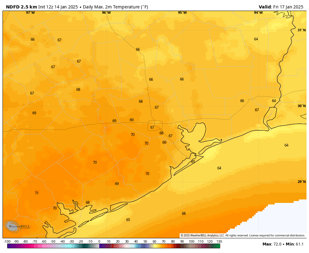
This will be a warmer day, with highs near 70 degrees and partly sunny skies. However, there will be chance of showers later in the day, and possibly a few thunderstorms out ahead of a cold front that’s due to push through on Saturday. Lows on Friday night will only drop into the upper 50s, which will be our warmest night for quite a while.
Saturday
The cold front is on schedule to arrive on Saturday, perhaps sometime around the middle of the day. We’ll be reasonably warm ahead of the front, and it looks like colder air will lag a bit behind the frontal passage. So with partly to mostly sunny skies, we could see some highs in the upper 60s. However as evening rolls around the northerly winds will start to really ramp up, ushering in colder and drier air. Look for overnight lows to fall to around 40 degrees in Houston, or a bit lower.

Sunday
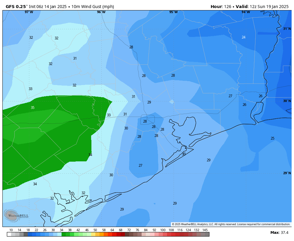
If you’re going to be on the start line of the Houston Marathon on Sunday morning like me, you’re going to want to prepare for colder temperatures. The good news is that I don’t expect any precipitation, and skies most likely will be partly to mostly sunny. The bad news is that winds will bring an additional chill into the air. I expect sunrise temperatures to be in the upper 30s in downtown Houston, with the likelihood of wind gusts of 20 to 30 mph. So it will feel really cold, especially in downtown with the tunneling effect between buildings. Even for people who like to run in cold weather, like me, this is pretty chilly. Highs will reach about 50 degrees later on Sunday before temperatures plunge on Sunday night.
Next week
So how cold will things get next week? We just cannot say for certain yet. I think we are probably looking at lows in metro Houston anywhere from the low-20s at the low end, to low-30s at the higher end of the forecast. So that’s the possible range. The coldest days look to be Monday, Tuesday, and Wednesday before temperatures moderate toward the end of the week.
As for precipitation, there’s a non-zero chance of snow or sleet on Monday, Monday night, or Tuesday. I do think snow is at least a possibility, because the atmosphere looks to be freezing all the way down to the ground. But it will depend on whether we get any precipitation, and how much, and at what hours of the day or night. I think the bottom line is that we might expect the possibility of some travel disruptions on Monday or Tuesday of next week, but that does not mean serious issues are likely. We’re just going to have to see how the forecast plays out over the next couple of days. Matt and I will be watching things closely for you.

🌬 ❄❄❄
Stay warm everyone
Was watching some other news channel this morning, made the artic blast next week sound really scary, but after reading this I’m less worried about it. It’s still something to consider, but hopefully won’t be too bad.
Thanks
That’s because SCW, unlike the TV stations, isn’t trying to scare you into watching again. And again. And again.
Yeah I saw scary projections too – like single digit temps here w ice & snow. Models keep changing. Glad SCW is here to moderate.
Baloney. I’ve not seen a single forecast for our area with single digit or even teen temps. No one is trying to scare anyone.
It’s definitely not baloney – the Euro on Sunday morning was showing a very cold scenario. I was shocked – I checked it on Sunday afternoon and it showed Cypress, Katy and Houston proper at 8° on Wed 22JAN2025 early in the morning. The Woodlands & Sugar Land lucking out at 10°.
So, yeah, people are right to be concerned, especially with forecasts bouncing around like that. The ECMWF is a good model.
Should I start panic buying toilet paper now or…
That might be the the only pipe insulation available at HD after about noon today.
🤣😂🤣
I’m supposed to be out of town next Tues-Thurs. Should I cancel the trip/flight??
Yes. Cancel. Everyone knows planes can’t fly when it’s lower than 32 degrees.
Hi, Ted. Enjoy the beach, but maybe shut your water off before you go!
This January is honestly nice, it feels like that of ’78 with many days staying very cold. I’m just hoping winter doesn’t instantly end in February like it did in 2018 when January was met with multiple freezes followed by our 2nd warmest February behind 2017.
I was thinking the exact same thing
It’s nice to have a runner reporting on Sunday’s weather. Could you please comment on last year’s marathon weather for comparison? It was cold, but hard to remember how cold.
KIAH recorded a low of 33 that morning (1/14/24). So a degree or two higher in downtown area. I volunteered at mile 8 and do remember it being a bit breezy out. As it stands – right now – the NWS Forecastpoints site still shows lows in low 40s, with upper 30s wind chill. If front comes in earlier and cold air spills in a bit faster behind, then obviously these values drop accordingly. With cold air advection and continuing northerly winds, it’ll be slow to warm out there Sunday morning.
C’mon, need more details. Should our group get our tights out? We want to match.
Damn, we’re good!
The cold rarely frightens me. It’s ERCOT and the grid that does. I’m just hoping the power stays flowing.
Exactly
I can’t absolutely guarantee this but I am highly confident that this cold weather pattern we are in right now is probably going to end in February. The abnormally warm conditions will likely return and stick around for the long haul this time. The colder than normal weather we are experiencing now will be completely leveled out in February.
Even though we can still get sustained cold spells, we have not been able to have 3 months of steady winter for years. The last winter to average below normal was the winter of 2020-2021. And that was only very slightly below normal mainly because of the freak February freeze that year. Before that the winter of 2014-2015 was the last to average below normal. The cool and cold air does not have the staying power it used to have back in the day.
So, it’ll start to warm up in February?
whew
No!!!!
The Gulf has really cooled off and will continue to do so with this arctic front. So my guess is a normal or below normal February. We will see how it plays out…
Depending on the jet stream pattern
Hey Eric, What kind of weather are the Texans going to encounter in KC Saturday afternoon?
Cold weather
Duh!
Would what’s currently predicted be considered a “hard freeze”? Full winterizing prep?
I’m not 100% sure because the qualifications for a “hard freeze” changes depending on the region. For our area, I believe a hard freeze is when the air temperature drops to 25 or below for 2 to 4 hours. But then I’ve also heard them classify 28 degrees as a hard freeze, so I’m not too sure. This is why anytime they predict temperatures to drop into the 20s, I always take measures like wrapping exposed outdoor pipes and sensitive plants even if it doesn’t happen, it is still better to be prepared.
….and….cue the reporters all bundled up and looking for a snowflake. The best comedy is from people not trying to be funny.
The worst part of running in the marathon when it is really cold is the ‘not running’ waiting around for up to an hour at the start. It’s okay if you go out of the house, start a run and can be sure of returning to a warm environment as soon as the run is finished, but the way the Houston Marathon is organized for the benefit of elite runners makes the whole ‘corral’ staging experience at the start really miserable.
All major marathons use the corral system and elites are always up front. It’s been this way for decades – everywhere. Wear toss-away clothing with a hefty bag over top for wind break. Warm up inside GRB, jumping jacks, squats, whatever, to get your core temp up a bit. No need to hit the corral an hour ahead of start time. They don’t close that soon relative to start time.
Well, it all really begs the question, why run an organised marathon such as the Houston Marathon?
1: to run 26 and a bit miles? You can do that any day of the week on any of the Bayou Trails with a lot less hassle.
2: want to run with your pals? See 1.
3: want to see how fast you can run? See 1.
4: want to test your running time against others? Plenty of apps and web sites for that these days.
5. just want to look good to your friends waiting in the cold for you to run past them? Please, give them a break, they are only there because they’d feel guilty otherwise.
Marathon running! The ultimate narcissistic event. 🙂
And they buy all the professional photography pictures and help to put food on my table. Keep on running!
LOL, yeah! Can’t start the day without hearing all about Tim L’s latest running details and opinions
oh I feel for y’all for sure. I know the Dallas marathon right after the start line, there are loads and loads of clothes that runners shed and workers pick up to donate to charity – maybe get some goodwill sweaters for pre-race corrals? I understand with the cold and wind though, I’m going to have to sit in it for 7-8 hours as the runners finish, snapping photos the whole time.
CenterPoint, you are on the clock!!
Luv your weather posts – fyi, you need to correct the spelling of “Houmidity” in your Houston weather.
Thank you, Eric. Good luck on Sunday! Stay warm, everyone. Also, friendly reminder if you’re going to be starting your car on those cold mornings next week, check your wheel wells, and knock on your hood to give any critters who found safe haven in or under your car time to move along safely.
Still a week out so obviously a lot can change, but the forecast seems like it’s steadily trending colder and colder for early next week. Now seeing a chance of snow being forecast for next Tuesday way out on the southwest side
Still waiting for you two to address the beautiful clear blue skies Monday flipped to dense clouds Tuesday as a result of the chemtrail planes crisscrossing the skies Monday. It’s a shame I can’t post a picture because I’d really like a believable explanation of man-made stripes Xing the skies.