In brief: Today’s post discusses why the month of October is often one of Houston’s wettest months of the year, but definitely is not in 2024. We look at our continuing warm daytime temperatures through the weekend, and the possibility of finally seeing some rain next week.
State of play
With high pressure more or less in place for the forecast period, we’re going to see warmer than normal days into early next week. However, the overall flow will be somewhat drier, so we’re going to see dewpoints lower than is customary in Houston. The net effect is that daytime temperatures will warm more rapidly, but nights will be a bit cooler than we might otherwise expect. Unfortunately, the overall atmospheric pattern will remain dry through the weekend as well, continuing our very dry October.
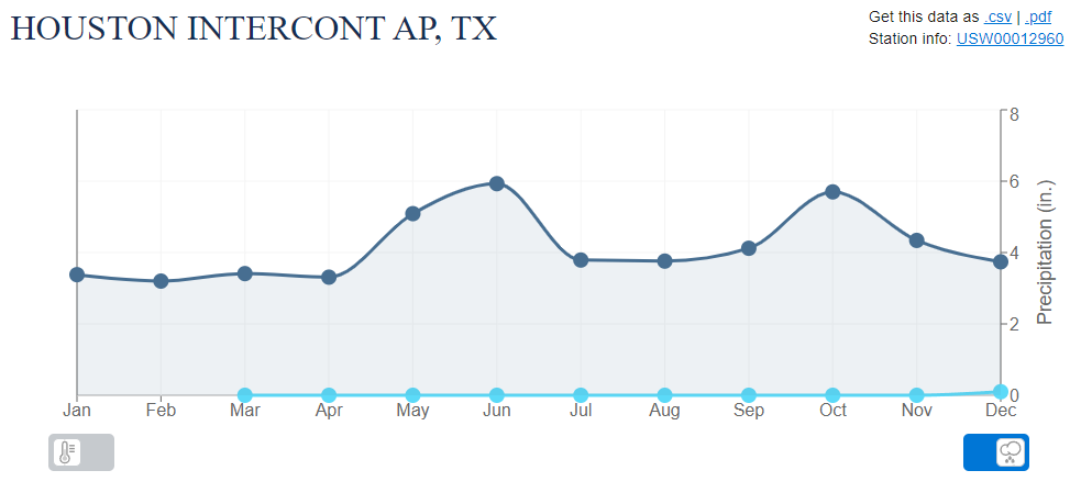
To date, the city has recorded 0.0 inches of precipitation this month. That’s surprising, because October is often one of the wettest months of the season. The historical average is 5.46 inches of rain, which ranks as the second wettest month, behind only June. Why is this month often so wet? We sometimes see late-season influxes influxes of tropical moisture earlier in the month, and often the fronts sweeping down in later October bring storms with them. We have seen none of that this year.
Tuesday
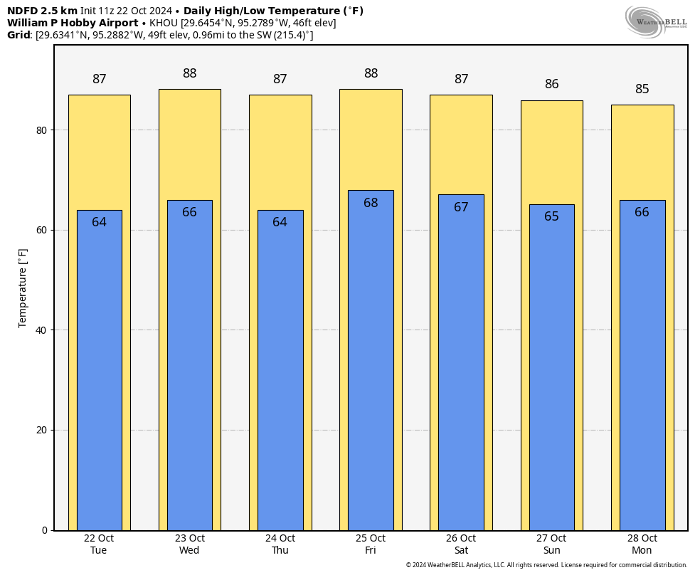
High temperatures today will reach the mid-80s for much of the area, although a few inland parts of Houston may push into the upper 80s. Skies will be mostly sunny, with a light easterly wind. Low temperatures tonight will drop into the mid-60s.
Wednesday, Thursday, and Friday
Skies will be mostly sunny throughout the week. High temperatures will depend on your location, ranging from the lower 80s near the coast, with the upper 80s in much of Houston, and pushing 90 degrees further inland. Days will be hot, but with dewpoints in the upper 50s and lower 60s, the air will feel modestly drier. Overnight low temperatures drop into the 60s for all but the coast.
Saturday and Sunday
You guessed it, more sunshine. Highs will remain mostly in the upper 80s, with lows in the 60s. The chance of inclement weather is basically zero, so if you have outdoor activities planned, you can feel pretty good about them. Provided you bring sunscreen, of course.
Next week
The sunny pattern continues into Monday, after which time we are likely to see the atmosphere become a bit more disturbed. This should lead to the development of some clouds by Tuesday, and some decent rain chances by Wednesday. I don’t want to over-set expectations, and no one should be expecting a few inches of rainfall to put a dent in our emerging drought. But the very dry pattern should finally begin to break during the second half of next week. The models are all over the place in terms of temperatures, so I don’t have much confidence in the weather for Halloween yet. If pushed, I’d guess that high temperatures are somewhere in the lower-80s, but I feel like that could be a trick.

A few inches of rain will refill my 600 g. water tanks so bring on the rain !
Thanks Eric. Flower farmer here, any hint at when the region gets a freeze this year in the long range?
Historically our first freeze comes around Thanksgiving. In more recent times, however, we don’t see our first freeze until well into December or even later.
Also – YMMV depending where in the metro you reside. Due to urban heat island effect, there can be a big temperature delta between the urban core (think inside Loop 610) and exurban areas (e.g., Cypress, Spring, TW).
Last year we froze on Oct 28, the year before it was after Christmas.
Not sure where you’re getting your data, but the coldest temp recorded in October 2023 was on Halloween, with a low of 47F – not close to freezing.
Source: https://weatherspark.com/h/m/9247/2023/10/Historical-Weather-in-October-2023-in-Houston-Texas-United-States#Figures-Temperature
I forgot about that one ! Looking at the archives here, it was a really strong front with rain beforehand. Looks also like a stretch of the polar vortex. Not in the cards for this year for sure.
Yeah that cold front dropped temperatures in the upper 40s all day on the 30th with blustery north winds. Highs on Halloween were in the 50s and then it dropped into the 30s Halloween night. That is definitely not normal around here though.
I’m hoping that with the warm fall we are having that it will actually be a cold winter persistent winter this time. It seems like when we have winter in October and November the actual winter ends up being warm. However with the upcoming La Nina in store for us, it will probably be a warm winter regardless with only quick 3 day cold snaps here and there.
Yeah… you have no idea what you’re talking about.
Troll
It’s obvious there’s no active Moderator out here.
lol. I live in Montgomery county. I’m a farmer and I know exactly what happened in 2023. https://spacecityweather.com/much-of-houston-to-drop-to-near-freezing-temperatures-later-this-week/
We were forecasted to 35, and we hit 31 in the open fields. An average first frost is just that. An average. Eye roll.
Early to mid December is our average first freeze. Definitely not in November.
Nui Detective please relax buddy. This is a friendly site. He must live well north of Conroe and is worried about his flowers. But should be no worries because the boys at SCW will give ample warning of flora damaging stuff heading our ways. Should get several days notice.
The cooler nights may save us from breaking our previous record warm October of 2004. The entire 2nd half of October that year was highs in the 80s and 90s with lows in the 70s. We were stuck in a persistent gulf flow most of that October. It was a freak event. Ironically that was the same year we experienced our miracle Christmas snow event.
False Fall 2 is over. Time for a False Fall 3 next weekend possibly.
It is not False Falls. It is early Falls.
It’s not fall anymore. There is no longer anything that can be called “fall” around here. It’s now called “not-so-freakin’-hot ” season.
Having just returned from a trip to Iowa, I noticed that all the states in the Central US are suffering from lack of rain. Since weather patterns seem to repeat is there any correlation between our current drought and the drought in the 1920s?
Contamination? What does this mean?
I’m sure he is referring to our excess co2 emissions. Those heat trapping gases are warming the atmosphere up more and more each year. That is what is causing these upper level highs or “heat ridges” to expand across the country more often and sit for longer periods. This is why our summers have been starting earlier and ending later than they used to. Droughts will happen more often and last longer due to warmer temperatures evaporating moisture out of the soils quicker.
This trend will continue and get worse over time. By the 2030s and 40s we will likely see periods of 90 degree temperatures extending through November. We will also start seeing 100 degree days in May and October. We were a chin hair away from that happening this year. Summers like 2023, 2011, and worse will become common place around here. I predict that we will probably experience our next warmest winter on record and hottest summer again before we even enter the 2030s.
I agree, the future is bleak and we might as well get used to it. We may be able to afford air conditioning and to water our yards, but pity the poor islanders who have not contributed to this mess yet will be the first to lose their homes because of it.
We really should ship the climate change naysayers to Micronesia.
I am glad we didn’t have this atmospheric setup in June, July, August.
It would have been 2023 all over again if that happened lol
Looks like “Severe Clear” for Wings Over Houston. Just uncomfortably hot on the concrete.
I’ll settle for some partially cloudy skies just for variety.
At least there is the HOPE of rain soon. I believe the official dry streak for Houston is 28 days now, but it has been about 40 days where I live. So that would be 48 days come Oct 30 where chances at least exist.
I’ve been watching Tidbits ocean analysis over time ….near Pacific tropics sea surface temperatures have been turning cooler – believed to be due to strengthened easterly trade winds away from the US – since May-June although La Niña still hasn’t been declared as yet. It’s surely headed that way. Big lag time tho and I can’t see otherwise why it’s so darn DRY now. Any experts please chime in.
My best guess by looking at recent maps is that we are in a strong positive Arctic Oscillation at the moment. This basically means that a strong and persistent upper-level low has been sat up in the Northeast Pacific near Alaska. The strong counterclockwise flow around this Low usually causes a Zonal flow in the upper-level winds over the United States which keep the cool air and the rain making systems north of Texas. This also often causes blocking upper-level highs aka “heat ridges” to sit over Texas especially during the fall or spring. This Arctic Oscillation pattern can last days or weeks at a time.
Usually for us to get colder weather we need to be in the Negative AO. This is when a sharp ridge of high pressure nudges up over the northeast Pacific into Alaska. This causes the polar jet stream to buckle over the U.S. sending rain making troughs and colder weather into Texas. It’s easier to understand by looking at the 500 millibar maps. There are of course other factors that come into play but that is one of them. The atmosphere is a very complex and difficult system. We may figure out the secrets of the universe before we are able to understand our own atmosphere 100%.
The ESNO and the AO can work together sometimes but in many cases the AO can contradict what we would normally expect from LA Nina, Neutral, or El Nino.
Thanks for this. I need to get familiar with AO. So many different acronyms for the long term weather cycles. ENSO the most famous. Sometimes compounding sometimes canceling. Makes you wonder how anyone can make a conclusion about the weather other than what’s going to happen between now and next week.
No problem and yes, I agree one subtle change in one feature of the upper atmosphere can completely alter what was predicted in the forecast in less than a day. sometimes.