In brief: After last week’s widespread showers and thunderstorms we expect more rain this week. But with the potential for flooding diminished, we are dropping our Stage 1 flood alert. Daily rain chances should also help keep highs in the vicinity of 90 degrees.
A week of rain, more to come
The region received a much needed dose of rainfall over the last week, with totals varying from 2 inches (generally in Katy and points west) up to nearly 10 inches (near Baytown). Most areas fell somewhere in between with a total of 4 to 6 inches. The rains were spread out enough that they did not cause too significant of flooding issues, which is not always easy to pull off in June, when rain can come down in bunches.
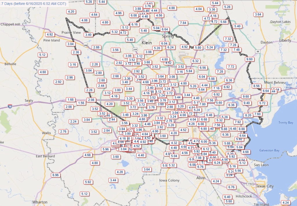
For the coming week we are going to see a ridge of high pressure attempt to build in from the south, but the Houston region should remain on its periphery. Generally, then, we can expect to see daily rain chances but probably not conditions as well organized as last week. So keep an umbrella handy, yes, but we are not too concerned about flash flooding. For this reason we are (finally) dropping our Stage 1 flood alert for the region.
Monday
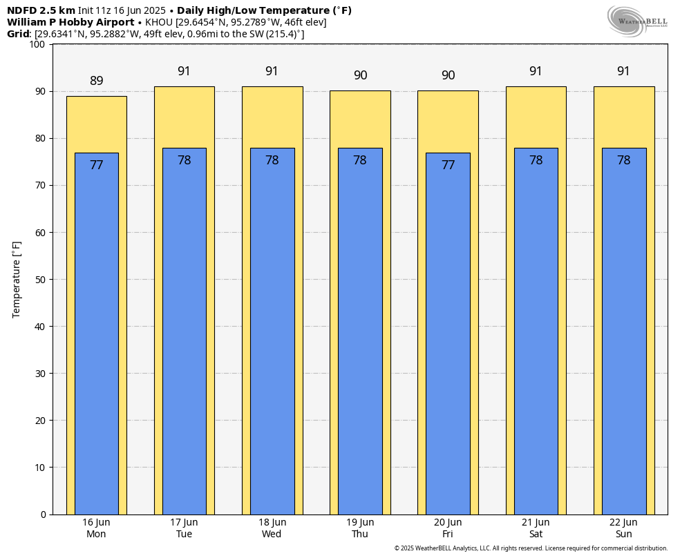
Most locations, especially south and east of Highway 59/Interstate 69 will see some rain today. And we cannot rule out some stronger thunderstorms this afternoon which may drop up to about 1 inch. Skies will otherwise be partly sunny, with high temperatures in the upper 80s to lower 90s, and fairly light winds from the south. Low temperatures tonight will only drop into the upper 70s for most locations.
Tuesday and Wednesday
Rain chances are lower during the middle of the week, due to the aforementioned high pressure, perhaps around 30 percent daily. I expect both of these days will see high temperatures around 90 degrees, or a tick or two higher, to go along with partly to mostly sunny skies. There is a 100 percent chance of mosquitoes after the last week or so of rains. I’m afraid they’re going to be bad, y’all.
Thursday, Friday, Saturday, and Sunday
The end of the week is likely to see a pattern of partly sunny days and high temperatures in the low 90s. Highs will depend on whether it rains during the peak heating of the afternoon hours. And I do think it will rain. Each day will see around a 50 percent chance of showers and thunderstorms, with “storm-o-clock” coming during the afternoon across the Houston region. If you have outdoor plans this weekend, I’m not anticipating a total washout, but you’ll want to have a thunderstorm contingency.
Next week
At this point it looks like this slightly unsettled pattern will continue into at least the middle of next week, with daily shower chances helping to keep temperatures at a moderate level (for Houston) in late June.

Bring it on daddy o.
This is fantastic, and even if the ridge does nose in for a bit, we’re not expecting a shutdown of rain chances. Hopefully this will continue to be the summer theme.
The new July through September outlook map (and I know, take it for what it’s worth) shows COOLER than average temperatures for our area. Keeping my fingers crossed that’s the case, and not because of severe or tropical weather.
What’s wrong with your weather app. Still shows 14 Jun for Tomball. That piece of data doesn’t make for much confidence in any of the other data. Did I miss an update to the app?
Hi, Doug.
If you see out of date weather data, there are two things you can do. Pull down on the screen – that is the first way to refresh the data. If that doesn’t work, go into settings (City-picker tray, tap the gear icon in the upper right and then tap “Refresh Weather Data.”
You can also kill the app (on iPhone and Android, swipe partially up until you see the whole window, then swipe up to kill it). Deleting/reinstalling is an option of last resort.
If none of that works, please use the “Send Feedback” button in the previously mentioned Settings page and provide as much detail as you can about what’s happening. This sends a log and some details about your device to our developer.
We have released a new iOS version for testing that fixes the notification problem (fingers crossed!🤞🏻), so if you’re on an Apple device, sending that feedback log would be helpful in general. Thanks!
Doug,
Looking into this, it turns out that the NWS Tomball station has been offline since June 14. Our app returns the most recent data it has. When it comes back online, you will see current data.
In the interim, select Houston as your city – that’s IAH, which is closest choice to Tomball.
I’m confused @Dwight … I occasionally use that website (we’re in Magnolia). Here’s what I see this moment:
Point Forecast: Tomball TX
30.09°N 95.6°W (Elev. 171 ft)
—-> Last Update: 8:32 am CDT Jun 16, 2025 <—-
Forecast Valid: 10am CDT Jun 16, 2025-6pm CDT Jun 22, 2025
… I’d say it’s online 🙂
Tomball (Hooks Airport) would be an ASOS, right? These do occasionally go offline for maintenance or repairs. Anything else (Point Forecast for example) is simply going to be model output extrapolation.
Click the link in my previous reply. Offline there. There are three stations in that vicinity that are offline, our developer tells me. The app is supposed to failover to IAH when this happens, and it did not. (Another bug report filed!)
I know a lot of people are tired of the rain, but I love the daily rain chances. This is the summer in Houston I love.
So what you are saying is that the high temperatures will be about normal to 5° Fahrenheit below normal while low temperatures will be 1 to 4° F. above normal.
If the downpours are hard enough, low temperatures can end up below normal.
The weather.gov ‘climatology’ link is a good way to view average high and low temperatures. It looks like average high temperature is ~92.8 degrees and average low is ~74 degrees.
On Saturday I was caught in a storm on West Galveston Bay that came out of nowhere. Intense lighting, pelting rain and wind in excess of 51 MPH in gust measured at San Luis Pass. Conditions went from beautiful to dangerous in about 10 minutes or less.
Lots o’ rain before the 4th is a great thing to help keep fire danger in check as well as keeping the plants happy. Doesn’t hurt either to get this heading into, climatologically speaking, the driest portion of the year.
Interesting observation, Even though Summer Solstice is June 20th, our sunsets only start to occur earlier in the day in early July. We’ve got a long way to go to get to October.
Yeah, we actually start losing daylight hours more on the a.m. side than the p.m. side for a while. There is a few days of plateau before this though.
NO.
Yes?
Maybe!
It was wild in Sweeny on Saturday. We had a massive thunderstorm fire up and sit over town with tons of dangerous cg lightning and dumping 4 inches in just an hour. Multiple streets were flooded and there was high water in yards. This was just 2 days after receiving 4 inches of rain on Thursday. It has been since 2021 that we had repeated downpours like this in such short time in my town.
Highs in the low 90s for 7 days in a row in mid June? Pinch me I must be dreaming.
I wish that on Friday you would discuss the drought situation in Texas. Hopefully it has improved.
North, East and Southeast Texas are drought free. South and West Texas are still pretty bad.
Here is a great map. It updates every Thursday: https://droughtmonitor.unl.edu/CurrentMap/StateDroughtMonitor.aspx?TX
Keep it coming guys!
1. My wallet likes the lower A/C bills.
2. I don’t have to worry about the yard dying again this summer.
3. If there’s a good game on Saturday or Sunday afternoon, I can simply say the grass is too wet to mow.
Little bit of hail mixed in on sw side!
Maybe the flood alert should have stayed in place. 3″ predicted for the Cypress area starting this afternoon. If this verifies Ch2 and Ch 11 nailed it in their forecast this morning. The models showed pretty much nothing but the talking heads didn’t believe the quiet forecast and called for continued heavy rains.
Genuine question. You all say a lot that the weather would be focused on the coast east of 59 but the exact opposite keeps happening almost every day. Major storms between Rosenberg and cypress but almost no rain makes it towards Pasedena/Texas City general area. It always dies out before crossing 45. Is there any explanation for this? I feel left out from the rain in Bacliff.
When the rain finally relented yesterday at about sunset here in Chappell Hill, we were greeted with the most amazing rainbow I’ve ever seen. Full arc and color spectrum over the cow pasture across the road. Gorgeous sunset on the other end, too. If there’s a way to share the photos here, I’d be happy to.