In brief: Francine is making its closest approach to the Houston area this morning, but remains a non-issue for the state of Texas. We’ll see one more cloudy and somewhat cooler day, with a chance of showers, before summer returns for a spell. We look to be solidly in the 90s for awhile after today.
Francine status
Francine has substantially increased in intensity overnight, reaching 90-mph winds. It should become a Category 2 hurricane before reaching the Louisiana coast this afternoon or evening. The storm will bring serious impacts to major populated areas of the state, including Baton Rouge and New Orleans. We will provide continuing coverage of these impacts on The Eyewall.
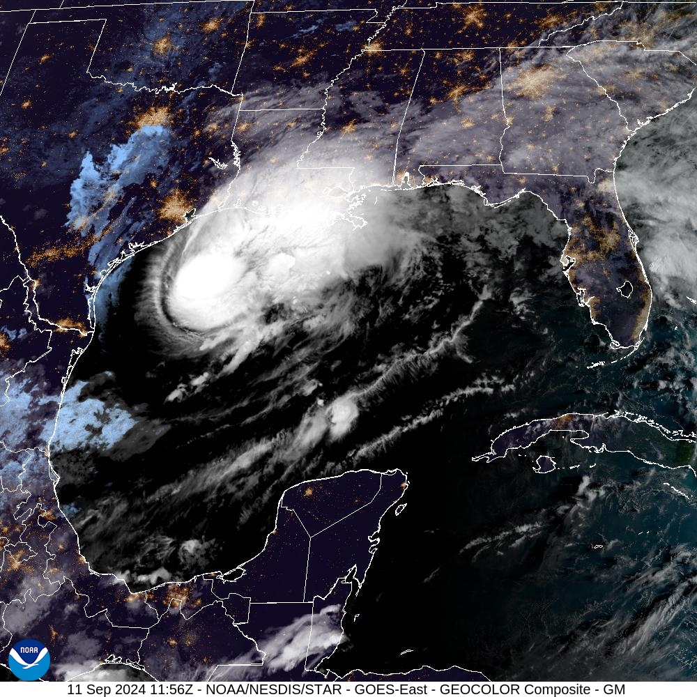
Locally in the Houston area, the impacts have been minimal. The storm’s center is now making its closest approach but is still more than 150 miles off the coast from Galveston. We have seen some slightly elevated winds—there was a single gust of 38 mph in Galveston last night—but for the most part sustained winds even along the coast have been 15 to 20 mph. For all practical purposes it has been a non-event locally.
Wednesday
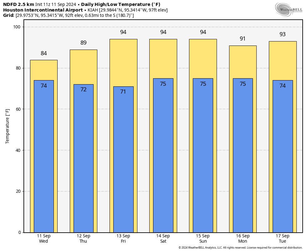
We’ll see mostly cloudy skies today, and that will help to keep high temperatures in the mid-80s. We’ll continue to experience north-northeasterly winds from the hurricane’s passage, and at times these could produce gusts of 20 to 25 mph. However, there will be nothing too out of the ordinary from this. Finally, we’ll see some scattered, mostly light to moderate showers throughout the day today. But overall rain chances for any given location are probably 50 percent or less. Low temperatures tonight will drop into the low 70s.
Thursday
Due to rains in late August and early September, and then the passage of Hurricane Francine, the Houston area has experienced a stretch of mostly 80s-days in terms of temperature. But just as a reminder, we’re still in September, and summer is not in fact over. We’ll be reminded of that, beginning Thursday, as the mercury starts to climb again. Highs will reach about 90 degrees, with mostly sunny skies and plenty of humidity. Lows will drop into the mid-70s.
Friday, Saturday, and Sunday
The weekend looks hot and sunny, with high temperatures in the low- to mid-90s. This will be due to Houston falling under the influence of high pressure. A very slight chance of rain returns to the forecast by Sunday, but it’s probably only 10 or 20 percent.
Next week
Houston could see a weakness in the high pressure system by the early part of next week, which could bring perhaps a 30 percent chance of showers for a few days. But for the most part of next week I expect partly to mostly sunny skies, with highs in the low- to mid-90s. There is a chance of a front about 12 to 14 days from now, but only a chance.
Tropics
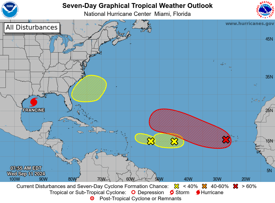
Beyond Francine the National Hurricane Center is starting to track more potential areas of development. However, at this time I don’t see any particular threats to the Gulf of Mexico. For this time of year, that’s a great place to be.

We are heading to Florida for the next week — is AL93 expected to threaten the area?
I’ll take another week or two of summer if it means we’re done with hurricanes this year.
Summer temps…Yuk…! Love SCW, please keep up your great work.
On the “…don’t see any particular threats to the Gulf…”. What would change that… would it be if these highlighted areas were farther south, or just if the yellows were orange?
“However, at this time…” you forgot to include thr first part of quote to give more context. Models right now don’t have storms coming in the direction of gulf, things could change but at this time no
I think we are done with Hurricanes.
That would be great! 😀
“There is a chance of a front about 12 to 14 days from now, but only a chance.”
So… You’re telling me there’s a chance?
Never tell me the odds!
Love SpaceCityWeather. Are there any North Texas focused weather sites you can recommend?
I’ll never forget. On this day, 23 years ago, I decided to take the day off and hangout and relax at home.
It was horrible to sit on the couch and watch everything unfold on TV with the Twin Towers and all the lives lost. I felt a little bit helpless, because I wanted to assist somehow, but couldn’t.
I’ll also never forget – I was in the Navy on the USS Nimitz – we were the carrier group sent over during the Iran hostage crisis. Met President Carter, when he presented an award to each of us. Have a photo of me accepting the award from him.
It was also the first time since WWII that a ship spent so much time at sea without a port of call. One day, we were each allotted 2 beers on the ship – you wouldn’t believe how much money folks were paying the non drinkers for their beer 😀
OK.
Thank you for your service and for sharing the anecdotes.
All this talk about the end of hurricane season after Francine sounds a bit premature to me. Sept. 12 is the exact peak of the season, so I would expect a slow downhill slog rather than an abrupt end. As I count them, there are still 80 days left until Nov. 30. That disturbed area near the Cape Verde Islands bears watching and has greater than a 60% chance of development. With luck it will die out over the open Atlantic, but it’s a potential threat to Florida and the East Coast.
I believe this is more in reference to hurricane season in Houston, which we are certainly approaching the end of. Very rare to see hurricanes hit Houston after the last week of September.
Is it too much to want both end to hurricane season AND and end to this hellish heat?