In brief: Scattered showers and storms will pop up in the Houston area through the day today, leading to locally heavy rain, especially east of I-45. A couple stronger storms cannot be ruled out either, again especially to the east. After a quieter period this weekend and early next week, we may be in store for more unsettled weather and rain chances late next week and weekend.
Rainfall update
Of note in Texas, there was some truly awful flooding late yesterday and last night in the Rio Grande Valley. Harlingen had nearly 14 inches of rain yesterday with over 10″ falling between 5 and 11 PM last night. It was their wettest day on record, with all but one other top 25 wettest day occurring between May and November prior to yesterday. For McAllen, it was the third wettest day on record. Even Brownsville cracked their top 25 list as well.
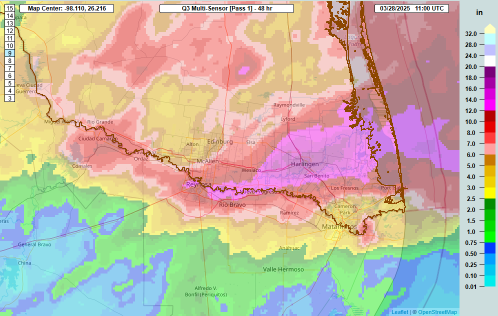
Locally, we have not seen that kind of rain. Fulshear and Simonton saw some locally heavy rain, with 1 to 3 inches falling there, extending north into Waller County. And areas southwest of Wharton and around Matagorda Bay saw 1 to 4 inches. Harris County saw rain yesterday, but most areas saw a half-inch or less.
Radar this morning shows some heavier showers in Liberty County but mostly calm conditions elsewhere. As the day drags on, look for additional showers and embedded thunderstorms to crop up. I would not be at all surprised to see some very hefty downpours occur, particularly along or east of I-45 later this afternoon. We are in a marginal risk (1/5) for severe storms, so any storm that we see today could produce some gusty winds or even a brief, isolated tornado, particularly between Winnie and Lake Charles later today. However, I don’t want to discount the Houston area, as we have not exactly had great model performance with geographic placement of storms this week.
Rain totals are a bit tricky to nail down, but I would say, expect around a half-inch in Houston with a few higher amounts possible east of I-45, lesser amounts to the west. To the east, we should see 1 to 3 inches, with even some higher amounts possible in spots. We will keep our stage 1 flood alert in place. Rain rates yesterday were easily near 3 inches an hour in the Valley, and that could be noted here as well.
So, bottom line: Scattered showers and storms today. Especially this afternoon. Locally heavy downpours, especially east of I-45, along with a low-end severe weather risk. Localized street flooding remains a concern in those areas with heavier, more persistent rain.
Saturday
I’m going to spin tomorrow optimistically. I think we’ll start off cloudy, perhaps with some areas of fog. There may even be a few light showers around. But as the day progresses, I suspect we’ll see improvement, with more sunshine, less cloud cover, and high temperatures popping back into the 80s. We should hopefully be able to keep the Houston Open moving along.
Sunday
While the majority of Sunday looks fine in the Houston area, there will be a passing disturbance to our north. As this occurs, it could be enough to set off some thunderstorms, primarily north of I-10 and especially north of Highway 105 across Navasota, Conroe, and Cleveland. South of I-10, storms will be unlikely. The most likely time for a few storms would be in the late afternoon hours, heading into the early evening. Everything quickly clears to our east by mid to late-evening. We’ll warm from the upper-60s into the low-80s.
Early next week
We should get a weak front through here Sunday night or Monday morning that ushers in some notably more comfortable air for a day or so. Thereafter, the onshore machine will pump back warm, humid air off the Gulf and into Texas by Tuesday afternoon or Wednesday. Low temps should remain in the 60s with highs in the 80s most of the time. Daytime highs could push upper-80s by Wednesday.
Later next week
A more unsettled pattern looks to settle in over Texas and more broadly the Plains and Southeast later next week, which could linger through the weekend. I don’t expect a ton of rain here right now, but I do believe our thunderstorm chances will increase. This may be especially true as you get north of Houston and northeast into Louisiana and elsewhere.
That said, it’s too soon to say much more than that. As we noted in our Q&A post the other day, sometimes there is enough signal in the model noise to highlight a forecast risk, and in this case that’s what we have late next week and weekend. Stay tuned!

This rain event seems allergic to Houston proper. Rain to the south and east but not in town. Oh well at least the lawns got a few drops. As far as the RGV goes, you can say that their drought is on the disabled list for awhile anyway.
In the southeast quadrant of I10 and 99, we got 1 inch yesterday.
Where are the torrential rains local news media were projecting earlier this week?
The projections served their purpose – scared people into watching more TV weather, hence increasing ratings and advertising revenue.
Do not ask for whom the bell tolls.
It’ll be our turn soon enough.
I’d say it depends on the station. This morning, Mike I. on Fox26 was downplaying the rains. He even said “I’m confident the Flood Watch will be lifted”. Sure enough, viewing just now, the Watch has been removed. He’s conservative and cautious, and not into the fancy rhetoric.
Another topic. I see some discrepancies at a couple of weather websites, specifically the radar images. They are are all in conflict, compared to the radar image at NWS Radar webpage, showing where the rain is and coverage area.
Well, 1/2″ of rain is better than nothing, I suppose.
Just as a expected, didn’t even get an inch in my yard and who knows when the next decent chance of rain will be.
Eric, Matt, I think I’ve read about a family of models that places an actual rain event into a watershed system including the antecedent conditions to check if a flood would have happened. Does SCW use these, such as what would have happened if these South TX rains had fallen downtown?
Big Municipalities (like Houston) have these models and can (and do) run simulations like this, however I would doubt if SCW has direct access to run these models as they’re pretty detailed. Though, I bet the model owners have already run these tests, and would hopefully be willing to share with the rest of us citizens. Maybe the gents at SCW could inquire and share with the rest of us!
No tornadoes please – we’ve had quite enough this past last year 🤞
I live in Houston/Clear Lake and the model forecasts the past few days (and regularly) have been AWFUL to put it mildly. Maybe one day with help from ultrasupercomputers the weather models can be believed, but NOT YET.
It’s been awful, bc they’ve GUTTED NOAA, its data & its radiosondes.
What exactly did you expect?
How about being grateful for Matt & Eric & Dwight, that they’re here to help us sort out this mess bc we’re in literal radio darkness now.
They stand between us and the pitiful yet dangerous detritus masquerading as weather information. They’re like a sunstone on a grey day in the North Atlantic, helping us get through this.
Stop complaining. And definitely choose a more appropriate name.
Um, okkkkkay, ‘PANIC’
smh lol
It seems like the rain models have been consistently wrong for the last year. You basically need to discount the projected totals by 75% in order to get an accurate forecast.
At my house in Sienna yesterday we got 0.51″ in the 24 hour period. And since Midnight, we have received only another 0.13″. Weather Underground is projecting a total of 0.4″ today , and another 0.2″ tonight. Nothing like the doomsayer predictions that ABC13 and KHOU weather guys are/were talking about.
Beaumont again.
Amazing.
At 1:00 p.m. central has anyone taken a good look at the radar?
You get a complex of thunderstorms around Victoria, Matagorda Bay, and Wharton.It literally skips the city of Houston and now it’s an atomic bomb out by Beaumont and the piney woods.
Did a fuel air bomb filled with Rain-X explode over the city?
I’m slightly confused by the Reply. It was predicted a couple days ago, Victoria, Matagorda, Wharton, and those areas would be hardest hit.
Then in today’s forecast, the prediction is “rains mostly east of Houston area”. Beaumont is east of Houston. What’s so amazing about that?
If you put the radar map in motion, it’s obvious the path it’s all heading. (we use NWS Radar).
Just an observation at the time, Aggie.
But I’ll have a crows feet donut. NWS Radar has a nice cluster about to impinge on the city.
So we may get more than the models predicted after all.
Aggie: The only thing that might be “amazing” about it is that this is about the fifth or sixth time, maybe more, since the beginning of 2024 that the bulk of the heaviest rain trains right up through Beaumont and Lake Charles and largely spares Houston.