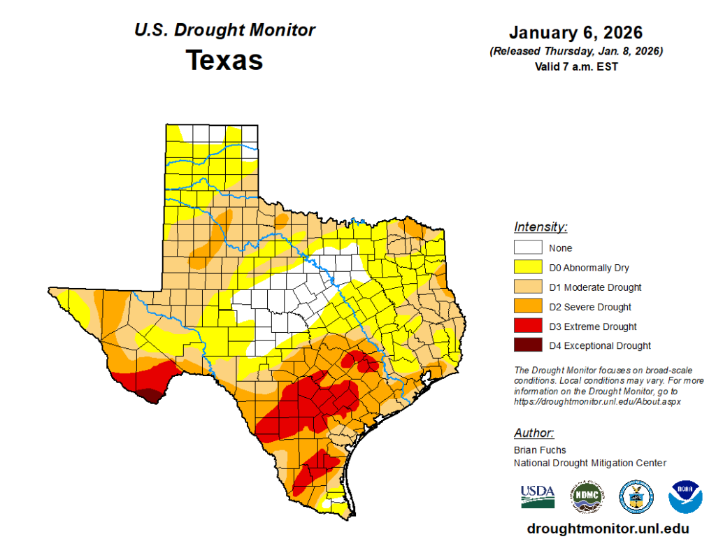
In brief: Today’s forecast is a tale of three fronts, which will keep Houston mostly on the cooler side of things into the middle of next week. The first two will be dry ones, but there is a healthy chance of rain with the third one next week. We could use it, as the southern half of the region has fallen into a ‘severe’ drought.
Rain wanted
Some parts of the Houston area (i.e. Kingwood, Cypress, Spring, Oak Forest, and other nearby environs) picked up a decent amount of rain with last weekend’s cold front, but for the majority of the region totals were far less. For some areas on the south side of Houston, it has been more than six weeks since a solid rainfall. And according to the most recently issued US Drought Monitor, a large slug of the southern half of the metro area has now fallen into a ‘severe’ drought.
I don’t want to over-set expectations, and it’s always possible this could fizzle out. But it does seem likely that the Tuesday through Friday period of next week will bring a decent chance of rain into the region. We are not talking the potential for flooding, I think. And in a normal period this would not be particularly noteworthy. But after such a dry winter so far, the potential for 0.5 to 1.5 inches of rain next week is worth highlighting. Anyway, we’ll keep an eye on things for you.
Wednesday
We’re getting a cold front today, but it will be a dry one. Skies will be sunny, with high temperatures pushing into the upper 60s. Winds are light, from the west, this morning. However by or before noon we’ll see a wind shift to come from the northwest and then north, and this afternoon we should see gusts up to about 30 mph. This will bring in drier air, and push overnight temperatures down to about 40 degrees tonight in Houston, with cooler conditions for outlying areas. Winds will continue to be strong this evening before settling down a bit after midnight.
Thursday
This will be a chilly day, with sunny skies and highs generally in the upper 50s. Thursday night will be a couple of degrees warmer than Wednesday night, but still chilly.
Friday
This will be a warmer day as southerly winds return. Expect highs of around 70 degrees. Before this warming trend becomes too pronounced, however, another front will push through.
Saturday and Sunday
In the wake of Friday’s front we will see a cool and fine weekend, with sunny skies. Expect daily highs of around 60 degrees. Saturday night should be the chilliest of the period. Most of Houston will likely remain above freezing, but some of the usual spots further inland could see a light freeze.
Next week
Monday, when we celebrate M.L.K. Day, will be pleasant, with sunny conditions and highs in the 60s. After this yet another front will push into the region, and this is when I think we may start to see better rain conditions. However the details are still pretty fuzzy. We also should start to warm up into the 70s by the second half of next week before another front some time next weekend.
