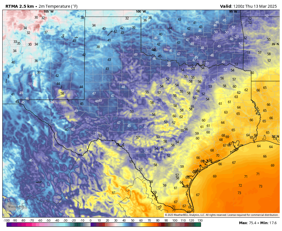
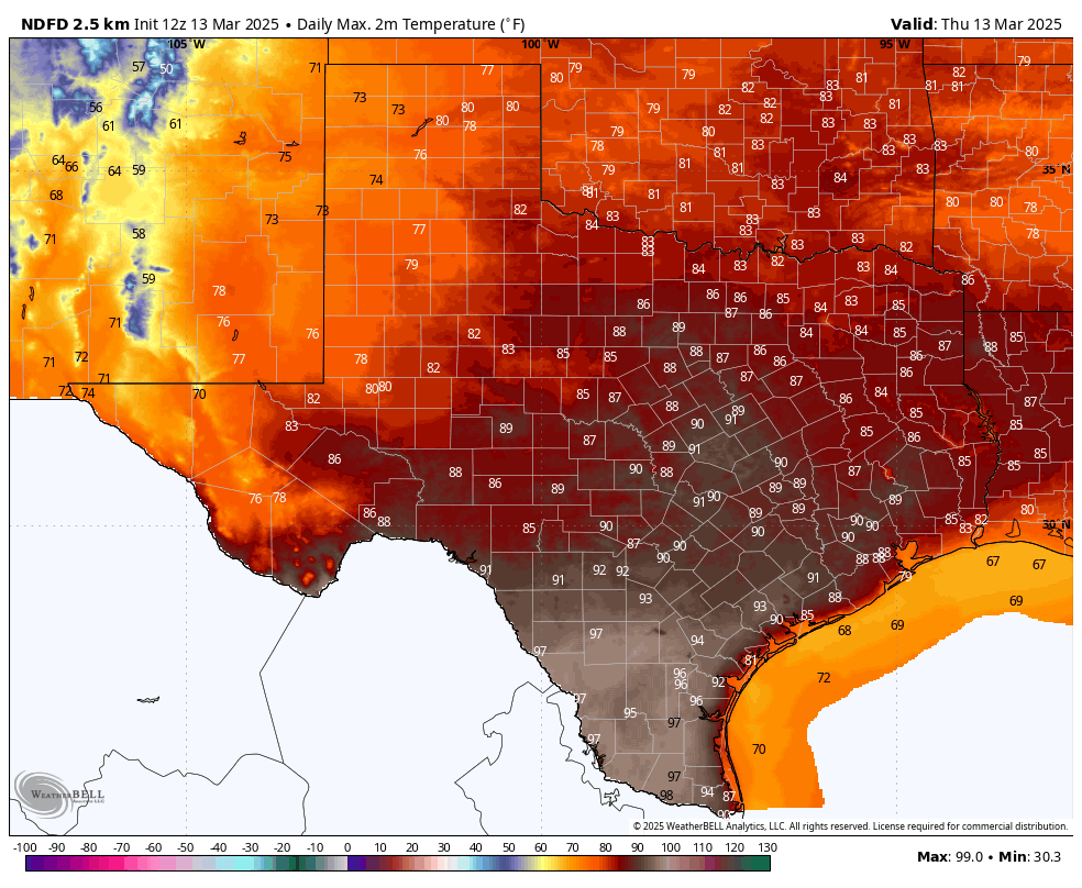
In brief: It has been 136 days since the city of Houston officially recorded a 90-degree day, back on October 27. Today, that may change. Parts of the region will hit likely hit 90 degrees. But that does not mean spring is over. Most of the next 10 days, including this weekend, should continue to bring beautiful, spring-like weather.
Thursday
After patchy fog clears this morning we should be left with sunny skies. The combination of a warm southwesterly flow and a bit of drier air will allow high temperatures to pop up today, with much of the Houston area in the upper 80s, and locations to the west and southwest of the city likely reaching 90 degrees. Only the coast will remain at about 80 degrees. Winds at the surface will, generally, be light at 5 to 10 mph from the southwest.

If you’re heading out to the rodeo this evening be sure to get there early, because a good friend of our family will be singing the national anthem to kick things off. It will be warm this evening, in the mid- to upper-80s. Temperatures will have fallen into the 70s after the show is over. Low temperatures tonight will only fall into the upper 60s for most of the metro area.
Another consideration for tonight’s weather is the lunar eclipse. Totality, at which point the Moon is tinted a coppery red, lasts from 1:26 am CT to 2:31 am CT. Unfortunately skies will likely be partly to mostly cloudy. However, there should be some breaks in the clouds that will allow for visibility of the celestial phenomenon.
Friday
With partly cloudy skies on Friday, and more pronounced southerly winds, high temperatures should be a few degrees cooler, probably in the mid- to upper-80s for most of the region. Given that a cold front is unlikely to push through Houston before Saturday morning, I expect another warm night on Friday, in the mid-60s.
Saturday
The frontal passage looks to be a dry one, but we cannot rule out a few showers on Saturday morning. However skies will quickly be turning sunny, and northerly winds at about 15 mph, with higher gusts, will be usher in lower humidity. Look for high temperatures around 80 degrees, with lows on Saturday night dropping into the mid-50s in Houston, with cooler conditions for inland areas.
Sunday
Expect a truly splendid day, with highs in the mid-70s, sunshine, low humidity, and light winds. This will be a top-10 day in Houston this year, weather-wise. Lows on Sunday night may push down near 50 degrees.
Next week
Monday should be in the 70s again before we push up near 80 degrees on Tuesday and Wednesday. Skies should remain mostly sunny throughout. A front on Wednesday will probably knock us back into the 70s for the second half of the week. If you’re wondering about precipitation, we could see a decent shot of rain about 10 days from now. We’ll see.

What an honor for your friend to sing the National Anthem! My son is tonight’s honored military service member. A proud night for all of us.
quoted: “… with much of the Houston area in the upper 80s, and locations to the west and southwest of the city likely reaching 90 degrees.”.
I’m currently watching KBTX channel 3.5 (Aggieland 24 hour weather channel), and they are predicting a high of 90°F today and Friday. The Almanac slide shows the Record high for this date is 91°F, in 1904.
We’re expecting the same temp here in Magnolia. Sure wish the “beautiful spring-like weather” would include some rain 👍
On March 30th, 1946, it actually got all the way up to 96 degrees in Houston. That is the hottest March temperature on record for the city. It was caused by a similar set up with southwesterly winds filtering hot dry West Texas desert air into the Houston area.
Thanks Eric 😊
On the rain 10 days from now. Recent rain events have grossly overperformed in spots. People know this is the weather’s fault. SCW uses wording like “— inches and in some spots a bit more”. Why don’t you develop a parameter, or something, that differentiates between “high” and “low” potential of some spots getting double the predict? There are events where SCW said “1-2 in and a bit more in spots” that verified. And events with the same words where spots got 6 in. The antecedents for these would have supported a guess on potential for big upside and hearing the guess is useful. I would literally say “our guess for doubling in spots is high (or low)”.
meteorologists tend to be careful of their wording, ex. “chance” “scattered” instead of “guess”.
Not saying your wrong to ask, but to understand their point of view of articulating a competent, accurate as possible weather prediction based on the data they have
There has to be SOME way to make up for the data holes the models now have – I’m assuming 2X worse for storm events now.
I’ve been eyeing the GFS & ECMWF vs what is happening in actuality since the first round of NOAA cuts. It is deeply concerning.
No one is discussing the 2nd round of NOAA cuts. It seems like no one cares or are too afraid to address these issues.
We need to deal with them instead of sticking our heads in the sand. That’s what it seems like we’re all doing here – NOT dealing with what’s important. Not even discussing the best way to deal w the data gap.
This is the best weather site I know, but there’s loud silence.
Spring Springeth. I mowed the front yard this morning, and reminded me that an old man with a bad heart needs to find a less stressful way to do that job. I’ll do the back this afternoon in the hottest temperature, then blast out my first dose of weed ‘n feed. ‘Tis the Season!
I think Eric was using irony about the “…rain 10 days from now…”. I had to look. By then and afterwards we’ll be glad to have anything from a spotty light touch to an open spigot. One thing I’ve learned here is that he never goes 10 days out and leaves that to us to have fun doing so. Joseph’s southwest wind is well and truly established and nothing is coming south that I can see on the long range. Soon it will be time to unblock the irrigators from winterization. The hose is too much work.
In a decade or two, gone will be the days of saying that it’s been 136 days without a 90 degree day.