In brief: The calendar reads May 12, but although June remains several weeks away today is the final day of spring for this year. Beginning tomorrow summer arrives in Houston and it does not appear likely to relinquish its grip. The region faces hot and sunny weather for awhile.
The end of spring
Looking back with hindsight, we might say that spring began on February 26 in Houston this year, a day when the high temperature reached 82 degrees. From that point forward, the city would not have any more daily highs below 69 degrees. And all things considered, it has been a rather warm spring, with both March and April recording average temperatures more than 4 degrees above normal. However, May so far has been temperate with near normal highs and lows, and a pair of pretty spectacular spring-like weekends. For those dreading the onset of summer it has been mighty fine. Sunday evening, with sporadic sunshine and dry air, was just an incredibly fine time to be outside.
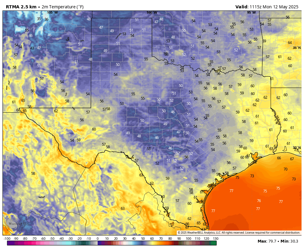
But all good things must come to an end. And we can say with high confidence that spring will end today. Consider this morning the final hurrah. It sure may not feel like it outside right now, with much of the area dropping into the upper 50s. Indeed, it feels almost chilly outside. But believe me, this is it. The high today will be fine, in the mid-80s for most locations. But tonight will be warmer and more humid, and then by Tuesday we’re off to the races with a high temperature likely reaching the lower 90s. Maybe we will get a final, weak front 8-10 days from now, but it’s not something I’d bet on.
Monday
Much of the Houston region has fallen into the upper 50s or lower 60s this morning, and it feels positively spring like. Winds are generally calm this morning, and may yet come from the northwest for a few more hours today. This will help hold dewpoints in the 50s for much of today, helping keep humidity levels low through this afternoon and early evening. With clear skies high temperatures will likely reach the mid-80s. By tonight we will fall into a much more southeasterly flow, allowing for humidity levels to rise. Lows tonight will only drop into the upper 60s.
Tuesday
Southerly winds will become much more noticeable on Tuesday, with gusts up to 25 mph or perhaps even a bit higher. With this southerly flow skies will be mostly sunny, and high temperatures will reach at least the lower 90s. Tuesday night will be warm, with lows dropping only into the mid-70s.
Wednesday through Sunday
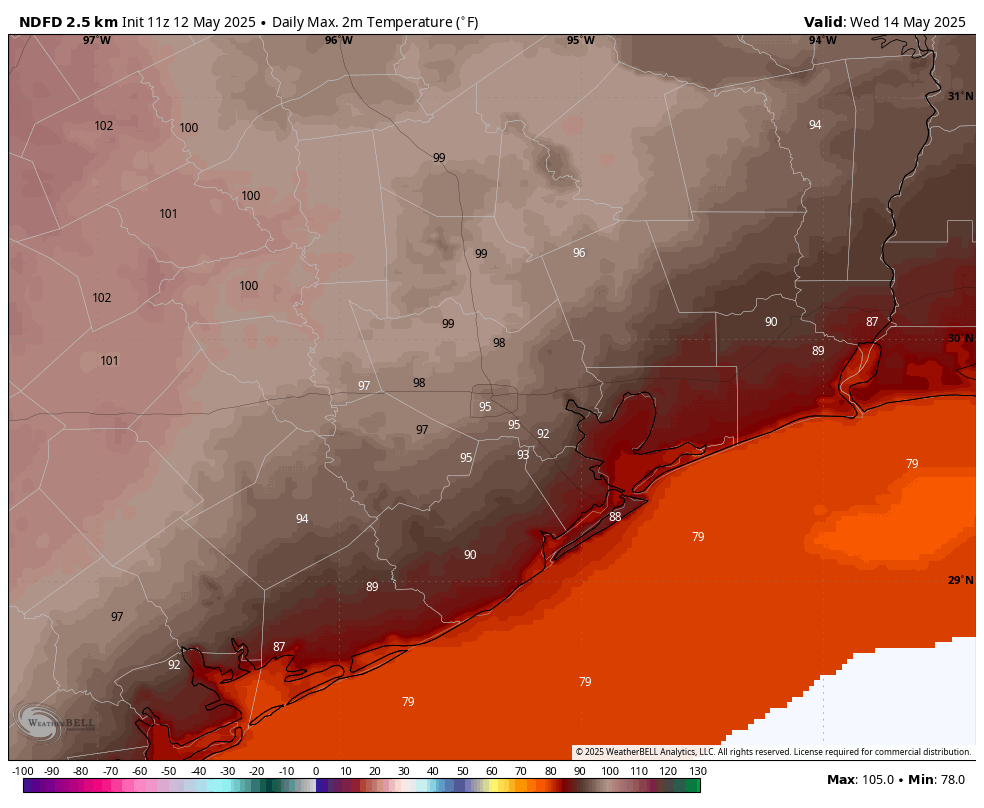
High pressure takes control, and we are going to see a hot week. Look for partly to mostly sunny days with high temperatures in the mid-90s, and mostly cloudy nights with lows in the upper 70s. Some inland locations will get into the upper 90s, with Wednesday likely to be the hottest day of the week. Rain chances will be virtually non-existent. With dewpoints around 70 degrees, the humidity will feel summer-like. From day to day there will be very little change in the weather, but there might be a very slight downturn in temperatures by the weekend.
Next week
The uncharacteristically hot pattern will persist into next week before some kind of front slides into the state. Whether it makes it all the way to Houston remains to be seen. But that will bring our best chance of rain for the next 10 days.

I’m attempting to look at the bright side if possible. We’ve had Mays where a hot start didn’t always translate into a torrid summer.
Yes there was 1998 & 2011. 2003 had temps near 100 degrees for several days but the remainder of summer was rainy and mild by regional standards. 2018 comes to mind as well. This region is not in a drought so here’s to hoping that that’ll buy us some credit for this summer.
Global warming is increasing our odds of the summer being torrid.
UGH! And this is just the beginning. Another 5-6 months of this “junk” ahead…..
As it is not mentioned, I assume this hot flash is not indicative of one of those heat domes that has made change and rain impossible in the region the past couple of years. …but is one on the horizon?
Yes that is what’s going to cause the heatwave next week but “heat domes” happen every summer here, it’s just some years they linger over Texas longer than others like 2011 and 2023.
This summer I plan to study the maps for the NM and AZ incipient monsoon season •• nominally June thru Sept. As I understand it, an upper level clockwise anti cyclone (aka a very large heat dome) over the western Gulf, Mexico, and points northwest is a prerequisite. That feature drives wind and Gulf moisture over the plateau and into those states. Positioned far enough east, I think it is the same heat dome that regularly brings us sinking air, heat, humidity, and drought.
For the remainder of May there is expected to be a rather strong dome over the upper gulf – but no NW wind yet over the plateau. So not the monsoon feature as yet. Maybe getting set up.
For me, understanding these macro features brings some acceptability to the weather here – it took a few years tho. It is not helpful to simply read ‘hot pattern persisting into next week’. Not knowing the ‘why’ is always frustrating. But observation is a powerful tool. We’ll see how this unfolds.
I couldn’t agree more with that 2nd paragraph. Not knowing the “why” is incredibly frustrating. It makes a huge difference if we’re entering a week of hot temperatures due to a typical high pressure system versus a 2023 summer of intense heat domes that won’t slide away from us for weeks. I really appreciate writeups like this and people such as yourself who seek to communicate the currently relevant context & macro features each time the weather shifts around.
It is the same one also known as the subtropical high. It is caused by rising warm air over the equator. This rising air travels northward, cools, and sinks over areas around 30 degrees latitude, which is where our region lies. This sinking air warms and compresses as it sinks, reducing cloud cover and preventing rain from developing. This is why most of Texas is notoriously so hot and dry during the summer and why most of the worlds deserts lie along 30 to 35 degrees latitude. If it wasn’t for the Gulf of Mexico, all of Texas would be a desert.
These pressure belts shift back and forth with the seasons. During the winter, the subtropical high weakens and shifts to the south.
I’m trying to be optimistic here for a change hot May starts does not always translate into torrid summers.
Yes there was 1998 and 2011, We know.
In 2003 we had several days of 100° weather and it turned out to be a rainy and mild summer that year. 2018 was like that as well. So far we’ve had a reasonably rainy spring and we’re not in a drought so I’m hoping that’ll buy us some credit for this summer.
That didn’t work for 2023. That was a mild and rainy spring as well but weeks upon weeks of brutal heat and high pressure quickly turned the scene of green lush grass and trees into a brown and yellow scorched hellscape with dead trees everywhere.
The weather during the spring holds little to no bearing on what the summer will do. Now spring can influence the beginning of summer but It depends solely on the pattern that develops deeper into the summer as to whether or not it will be wet or dry and brutally hot.
Typing error above. Anyway I think we had a good spring back around 95-98 when May 1st hit it was 90s plus until late sept-oct of those yrs so my opinion we are in May and had some great temps and we had some good rain but we live in the deep south close to southern equator so here we are and complaints per say.
Amen
1996 was the hottest May on record in Houston and still to this day. At the time 1998 was the 6th warmest. May of 1995 1997 were more temperate though.
RIP spring 2025, February 26 – May 12
You were hot (beginning of February) and then you were cold (February 19). You were dry (March 5 – April 19) and then you were wet (April 19 – May 11). Mostly you were warmer than normal, and mostly you let the humidity flow. The wildflowers didn’t bloom quite as much as usual. Sweat and tears (because of the sweat in my eyes) were had. But even with your quirks you were beautiful. Sure, we had bad days, but I had a lot more good days with you.
Regardless of anything else I will always appreciate you, spring of 2025. I won’t always remember you, but that is OK. Even if I don’t always remember you, I’m happy to say that you are still a part of me. Spring flows to summer and summer flows to fall. We are all part of an eternal cycle.
I’ll look longingly back at seasons past, and I’ll look optimistically forward to seasons to come. Rest in peace spring of 2025.
We should be happy that spring has lasted into mid-May. Summer begins May 1st in Houston and lasts through Halloween.
No, thanks.
Last comment towards the end no complaints not complaints.
😂 You guys sure know how to ruin the “party” of 59 F in The Woodlands during my morning walk between 6:30 and 7:30 today. Now, I’ll have to start the walk around 1:30 AM to avoid melting onto the sidewalk! 😂
Well I guess we have it better than central Tx – the Euro shows San Antonio at 109° on Wednesday.
Time to fly to my summer house in Colorado. Oh wait, I don’t have a summer house in Colorado…
Four seasons into twelve months… 3 months of spring sounds about right. It’s Texas gang. Heat/kitchen etc…
It’s so dumb how we jump from mild spring weather straight into July and August temperatures in mid-May now. There used to actually be a moderation between early and mid summer most years. Our already short window of cooler weather after summer is growing even shorter and shorter.
Highs on Tue as reported by Fox:
San Antonio 105°F
Austin 102
Abilene 103
Laredo 110
Dallas 96
Houston area 93°F.
… can’t complain if in the Houston area, compared to cities to the west and north.
.
Also snagged this from a stats chart:
RECORD HEAT THIS WEEK IN HOUSTON
Forecast High Tuesday – 93
Forecast High Wednesday – 97
Forecast High Thursday – 97
Forecast High Friday – 96
Forecast High Saturday -95
.
PAST RECORD HIGH TEMPERATURES
Tuesday -94 (1907)
Wednesday -93 (2018)
Thursday -94 (2018)
Friday – 94 (2022)
Saturday -96 (2018)
… guess we shall soon know 👍
Grumble, grumble, grumble. The haters are happy hating.
I think SCW needs to check their comments forecast. It seems on days Eric posts things spin negative, while days when Matt posts things are slightly less negative or god forbid positive.
There are UHaul rental outlets all over Houston. If you catch my drift.
Well, bless your heart, Madys. I guess you don’t get invited to many parties.
Im sure theres a list of places with worse weather, but Houston as to be up there right?
Going back may 2024 to may 2025. We had hot weather from may 24-October 24. November was a warm humid uncomfortable period. December was cool but not cold. January was the only month of winter.
The skill scores from the GFS are in the tank and the Euro has been much more reliable as of late. The Euro is forecasting highs a degree or three cooler for our highs. I think the hype train has been blown out of proportion. My guess is it’s going to be hot but a degree, two or three cooler than the GFS is spitting out. We will see…
Yeah, I noticed the Euro seems to have a higher hit rate at this point.