After a fairly nice day on Thursday, we are back to the cloud thing again today (though the east side might be seeing a good bit of sun initially). A storm system passing through tonight with a cold front will bring most of us some rain, locally heavy at times, before we clear out for the weekend. Read on for the latest on Christmas below as well.
Today
Most of today will be just fine, with nothing worse than some clouds. A passing shower is possible, especially near Matagorda Bay today or north and west of Houston this afternoon, but the rain should hold off for most of today. After 3 or 4 PM, rain chances do start to increase. Highs will be in the upper-60s to low-70s. Also look for some breezy conditions today, especially over the water and at the coast.
Tonight
The exact timing of the rain will vary from place to place, but generally look for a northwest to southeast progression of rain this evening after about 5 to 6 PM or so. Rain will fall through the night, heavy at times, especially north and west of Houston I think. There will probably be an axis of maximum rainfall that sits north and west of Houston, from Columbus to Conroe to Lake Livingston.
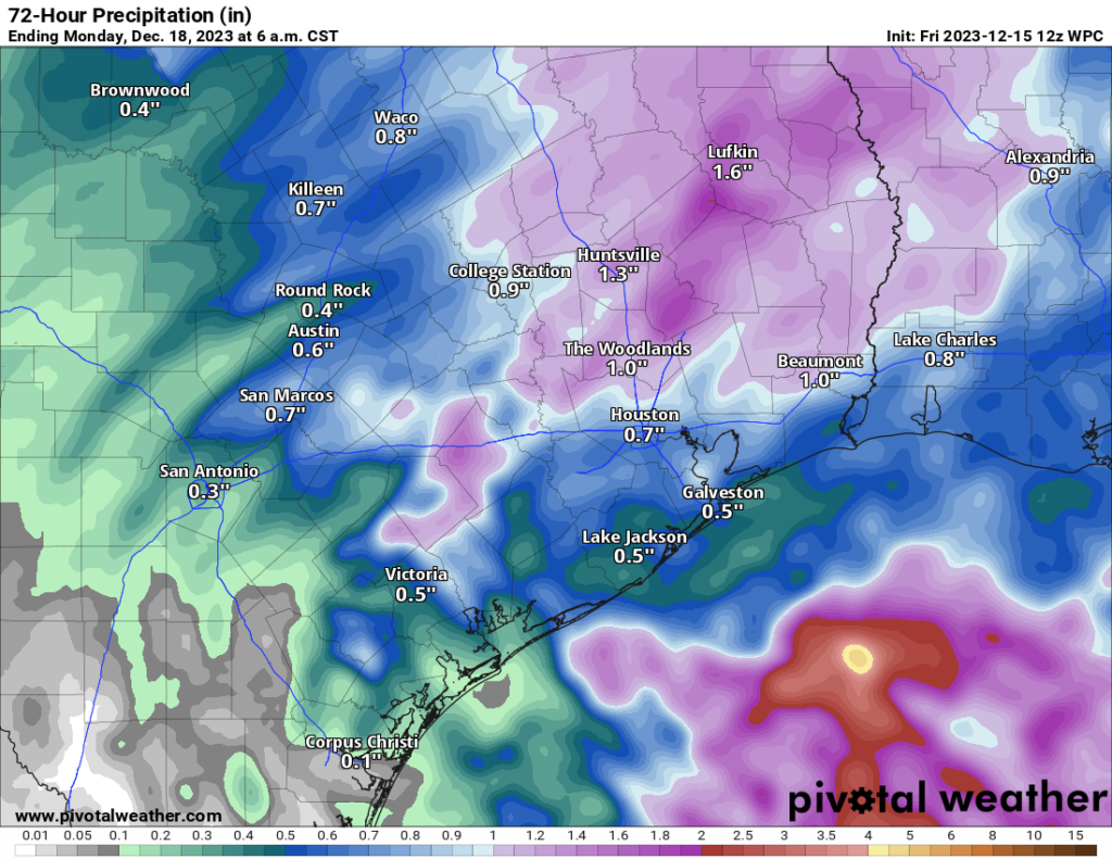
In that area, we’re expecting 1 to maybe as much as 2 inches, with slightly higher or lower amounts depending on exactly how things set up. For most of the city and suburbs, rain will push through but totals will vary a bit more, perhaps as little as a quarter-inch to as much as an inch or so. This will extend south and east until you get to the coast. Some locally heavier rainfall could fall near the immediate coast or just offshore. Some rumbles of thunder and some ponding on roads are certainly possible tonight, but we are not expecting severe weather or significant flooding. Lows will be in the 50s.
Saturday
Any showers should clear the area in the early morning, leaving us with clouds. We should see at least partial clearing during the day Saturday, but temperatures probably won’t get too far past 60 degrees in the afternoon.
Sunday & Monday
Both Sunday and Monday look like a great pair of early winter days. Expect sunshine with lows in the low-40s and highs in the low, maybe mid-60s.
Tuesday through Thursday
We don’t expect any significant weather for the middle of next week, but look for varying periods of sun and clouds. Days that are cloudy will be in the 50s to low 60s, while days with sun will pop into the mid to upper-60s. Morning lows should remain generally in the 40s to perhaps 50s by Thursday.
Piecing together the Christmas period
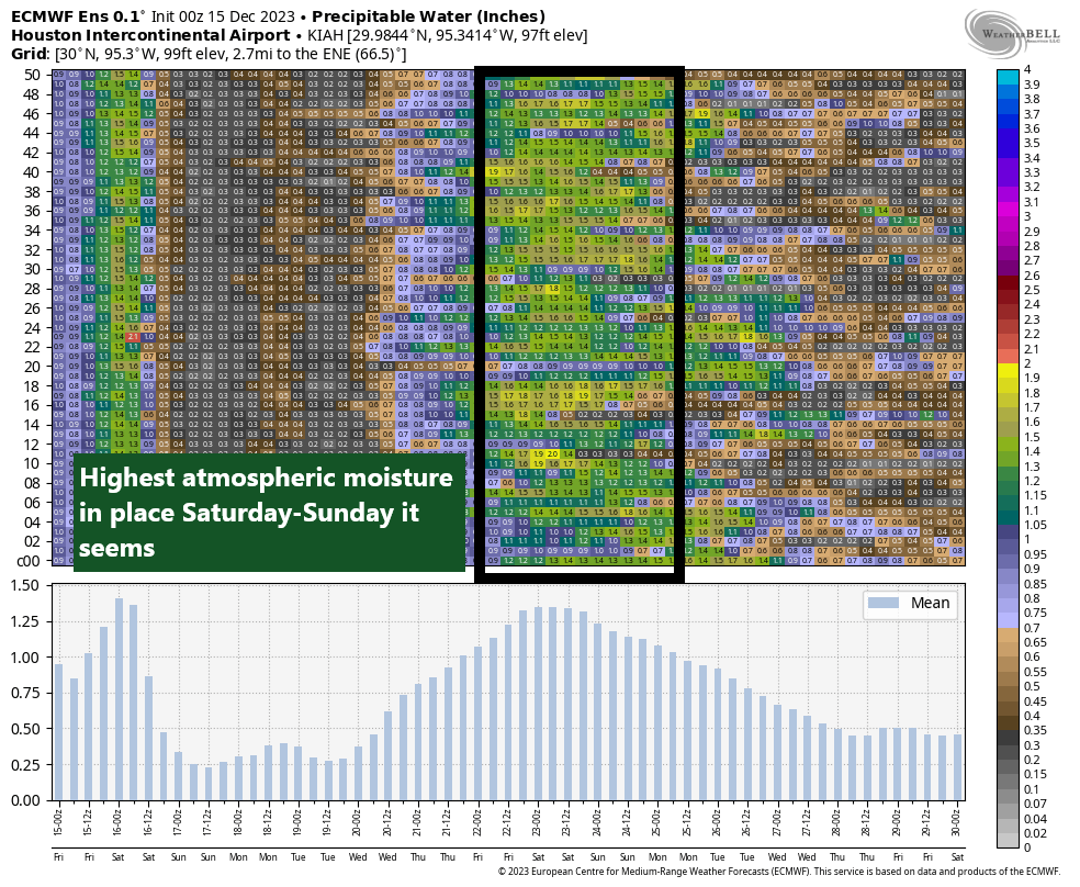
The Christmas weekend continues to look mild and potentially unsettled. Initially, look for warm weather and probably clouds and some sun with a slight chance of showers Friday and Saturday. It’s tough to pinpoint exactly what the story is next weekend, but between maps and charts, we can start to make some assumptions. Atmospheric moisture is likely to increase in Houston beginning Friday and Saturday. Right now, the European ensemble mean for precipitable water next weekend is around 1.25″ in Houston, which puts us fairly close to the 90th percentile of atmospheric moisture. In simple terms: There will be a good deal of moisture available to produce clouds and showers next weekend in the area.
Moisture doesn’t mean a whole lot unless there is a “trigger” to produce rain and storms. The best setup for that looks to be in interior Texas next Friday and Saturday, but that will march eastward Sunday and Monday, which seems to imply some sort of cold front.
So what’s it all mean? Expect clouds and some shower chances Friday and Saturday with a greater chance of rain on Christmas Eve or Christmas Day. Temperatures are likely to be a good deal above normal, with highs in the 70s likely, followed by colder weather after Christmas. We’ll see how this plays out over the weekend and update you with the latest on Monday!


Heading to Galveston Moody Gardens tonight with the kids. What is the expectancy for rainfall along the coast after 5pm?
I keep checking your weather updates to see if I need to shut off my water before being out for 1+ weeks! We were able to shut off our water before last year’s freeze on Dec. 23, just as we left town for the holidays. Thanks for all your timely reporting!!!
According to the Weather Channel, in the Moody Garden’s 77554 zip code area, there will be in between a 34% chance of rain from 5 P.M. to a 59% chance of rain at 12 A.M. midnight. The amount of rain could be more than 1/2 inch to more than 1 inch of rain. Street ponding could be possible. I hope this helps.
Based on these alerts I keep getting from FOX26, it’s gonna possibly be a rain ARMAGEDDON!!
Hahaha! Also from ABC13. I hate how all the comments are from people really worried for nothing…
Don’t worry my friends – your local TV meteorologists are keeping you and your family safe from the massive 1-2″ rains and the 20 mph winds.
All I took away from this pre-Christmas forecast is that moisture is probable & cold was mentioned somewhere. Since moisture that gets cold is snow, I’m basically expecting a white Christmas! Looking forward to it! Thanks y’all! 😅