In brief: Houston will continue to see scattered showers and cooler temperatures for a couple of days. Then, rain showers should become more widespread during the second half of the week, and we are starting to see the possibility of heavy rainfall by next Monday or so.
Potential flooding
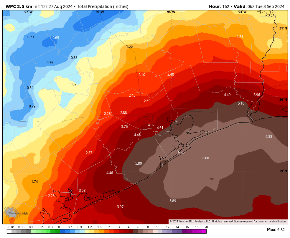
Over the last day or so, the model trends have been pushing toward a wetter pattern than expected for the next week to 10 days. Since the region has been so dry, and rain chances will be hit or miss over the next several days, I’m not anticipating any serious flooding during this week. However, in part due to a front stalling north of the region early next week, we could see the potential for more widespread and sustained showers.
The bottom line is that we’re watching things, and something like a Stage 1 flood alert may be necessary for early next week, potentially the Monday and Tuesday time frame, for coastal areas. Again, even in a worst case scenario, we’re probably talking about something that floods lower-lying streets. I just wanted you to be aware of our thinking.
Tuesday
Today will be something of a repeat of Monday, with showers developing offshore and moving inland during the morning and early afternoon hours. However, coverage does look likely to be slightly less than on Monday. Skies, otherwise, will be partly sunny, with highs in the low 90s. Rain chances will slacken during the evening hours. Lows on Tuesday night will drop into the upper 70s.
Wednesday
Like on Tuesday, rain Wednesday will be of a fairly scattered nature, with perhaps only about half of the area seeing a passing shower. Accumulations should not be too significant, with the hardest hit areas perhaps picking up a half inch or so, and most of the region less. Highs, again, should be in the vicinity of the low 90s with partly sunny skies.
Thursday, Friday, Saturday, and Sunday
Rain chances will increase as we get into the second half of the week, and weekend. I can’t find much to differentiate the weather on any of these four days, which is why I’ve lumped them together. Each day is more likely than not to see rainfall, and there will be chances for showers overnight as well. High temperatures each day will range from the upper 80s to lower 90s, so quite a bit cooler than is typical for late August. I don’t really have any flooding concerns for this period, but showers could definitely put a damper on outdoor activities. It certainly won’t be raining all the time, but showers may pop up any time.
Early next week
As a front stalls north of the area, this should provide some additional lift and juice our rain chances. Since we’re talking about a period a week from now, the details are going to be hazy. But with the potential for widespread showers, and some heavy rainfall, we necessarily cannot rule out the possibility of some flooding. We’ll see. Daily highs will remain in the vicinity of 90 degrees. Most of our modeling shows rain chances slackening as we get toward the second half of next week, for what it’s worth. Which probably is not a whole lot.
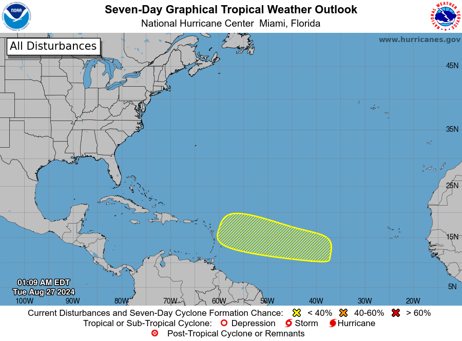
Atlantic tropics
After a quiescent period, there is a new system to watch. There is a chance that an area of low pressure in the Atlantic could develop over the next week or so, as it moves toward the Caribbean Sea. Yesterday afternoon some of our best global models were hot to trot, and ready to develop this system into a tropical storm, but this morning they’ve backed off some. There’s not much else we can do but watch at this point—the next month is the period during which we should be most concerned about the potential for powerful hurricanes to strike Texas. For more detailed coverage, be sure to check out The Eyewall.

I’m not sure who was more excited about yesterday’s brief rain in Spring: me or my plants.
No need to talk about flood threat a week out. 3 days out is unpredictable as it is. And that rainfall estimate map thru Monday is laughable.
Rude
But not inaccurate.
Inaccurate or not, it’s still rude
lol who farted in your cereal this morning
Chocolate milk
I’ll take the 4.61″ I’m under.
Stalled front to our north is a good sign. We just need that one bold cold front to make it on thru all the way to the coast!
Is there going to be low pressure in the Gulf, plus a tropical system entering the Caribbean, all immediately on the heels of this predicted heavy rain?
That’s what I’m seeing..I’m hoping with all my heart this rain/storminess doesn’t impact Sept 10th thru the 14th, beyond just being pop up showers..I have important family celebrations to go to, for one, my granddaughter’s birthday brunch 🙂
Just got 1/2″ quickly dumped on us in Copperfield!