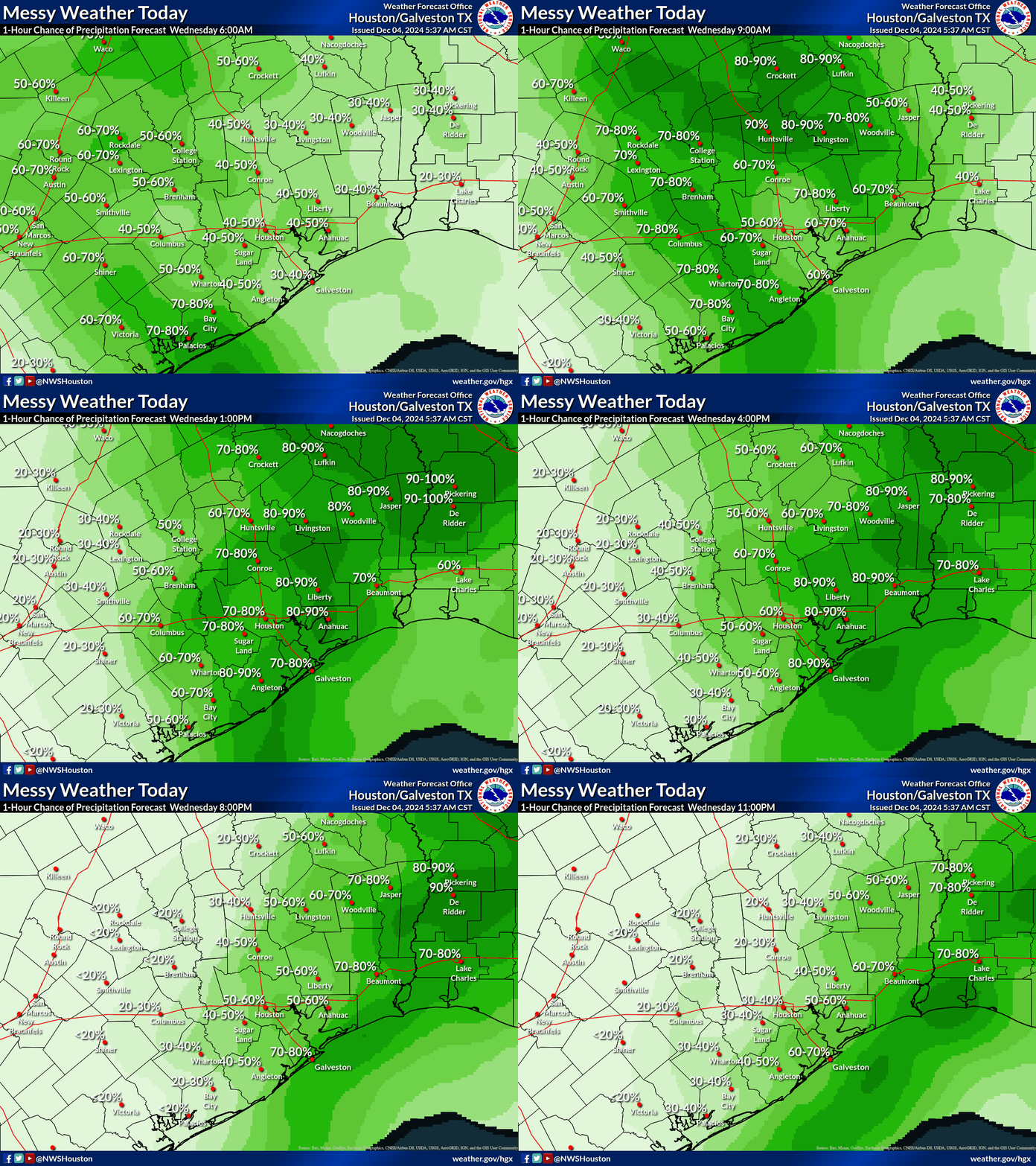
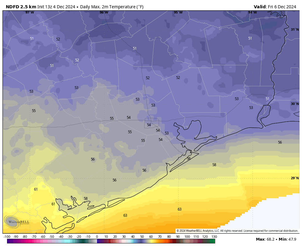
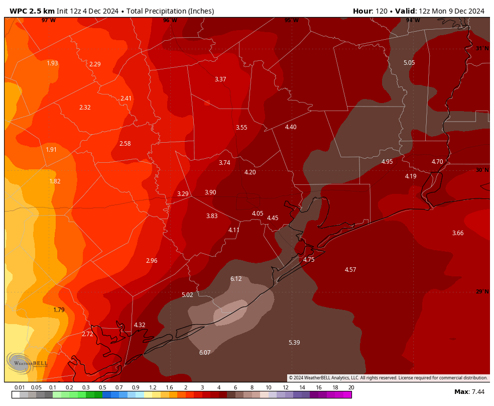
In brief: Our overall pattern is definitely changing, with rainfall likely today and tonight, and then again this weekend. Although precipitation will be plentiful, sunshine will be scarce until at least Monday. Our temperatures will go up and down, with Friday looking especially chilly even during the daytime.
Wednesday
Warmer and more humid air is spreading inland from the Gulf of Mexico this morning as a southerly flow takes hold, and this will set the stage for healthy rainfall today and into tonight. It appears that the most organized set of storms will move in from the southwest later this morning, pushing into the central Houston area around noon before lifting off to the east-northeast.

What to expect? Mostly this should be light to moderate rainfall. However there is a slight, and I do mean slight chance of something stronger such as gusty winds and thunderstorms. It’s possible that areas north of Interstate 10 may even see a tornado warning, but that is much more unlikely than likely to happen. Anyway, most of the greater Houston region should see some rain, with general totals on the order of 0.25 to 1 inch. However there will likely be some part of town, maybe in the Sugar Land or Pearland areas, that probably hits a bullseye of 2 inches or more. Chances for lighter rain continue this evening and into the overnight hours.
Highs today will reach the lower 70s, with fairly sticky dewpoints. Temperatures tonight will drop into the 60s, with drier air starting to arrive after midnight.
Thursday
As a cool front pushes the warmer air back offshore, look for a cool and cloudy day Thursday, with daytime temperatures likely in the vicinity of 60 degrees. Rain chances should be low to non-existent during the daytime hours and overnight. Lows on Thursday night are chilly, dropping into the low- to mid-40s for much of Houston.

Friday
A colder day still, with highs likely topping out in the 50s, beneath gray skies. Lows will again drop into the 40s on Friday night with some light rain possible late.
Saturday and Sunday
If you have outdoor plans for this weekend, I would describe the forecast as challenging. Saturday looks to be another cool and gray day, with highs in 50s to lower 60s. The likelihood of rain, probably light, is about 50 percent during the daytime hours. By Saturday evening and overnight we will probably start to feel the influence of a coastal low pressure system, and this will increase rain chances on Saturday night through much of Sunday. Highs on Sunday will probably be in the low 70s, with muggy air. The bottom line is that any outdoor activities on Saturday evening through Sunday night will face the distinct possibility of rain. Most of the area should see 2 to 4 inches of rain through Monday morning.

Next week
Skies look to clear out some on Monday, giving us our warmest day of the forecast period as highs push well into the 70s. After that another front appears likely, driving lows down at least into the 40s by Tuesday or Wednesday. We’ll have to see.

Sounds like Sunday isn’t going to be a great day to start my road trip headed east! Still, better than the time I did the same trip when a tropical storm was hitting New Orleans.
Typical of our Houston weather November was a sauna and December starts off below average. On this date in 2009 Houston recorded its earliest snowfall ever. 1″ at IAH…
Yes I was just thinking about that. That was also one of the best winters we’ve ever had. It was consistently chilly/cold through most of that winter. We went almost a whole month without one 70 degree day between December 23rd 2009 through January 18th 2010. Truly rare stuff for these parts. I wish we could have another winter like that, but the chances of that happening again are pretty grim I’m afraid.
I remember a Winter around 1997 where the temperatures were consistent for several weeks as reported by KTRK. The temperatures were most likely measured at Bush Airport.
For each week, the high temperature for six of the seven days was not above 60° Fahrenheit and six of seven mornings the lows were not lower than 40° F. For that period of time, it was nice to know what to wear most every day.
Winters like 76’, 83, and 89 may become rarer but even in a warming world we will have the occasional colder winters. The arctic outbreak in 2021 comes to mind.
That is very true, but there is some debate amongst climate scientists that a warming world may increase the frequency of 2021-type freezes in the South due to the polar vortex becoming unstable more often due to more intrusions of warm air. However, this is not fully confirmed because they say that not enough data has been collected yet to fully determine if that is the case or not. While there has been an increase in local Arctic cold snaps across North America in recent years, on a global scale, cold snaps have decreased on average since the 1970s and 80s.
What is definitely becoming rarer is having winters that average below the 30-year norm. Even when we get a harsh cold snap, it usually still averages above normal for the winter as a whole. While we will still likely see brief harsh cold snaps on occasion despite a warming world, having consistently cool\cold temperatures throughout the winter months will continue to happen less and less.
The world has gone through many climate changes in the past. The Medieval Warm Period, Little Ice Age, Roman climatic optimum etc… What ever caused those changes will continue to do so even in a warming world. One concern highlighted by a recent study is the stabilization of the Beaufort Gyre which at some point will unleash a huge influx of freshwater trapped in the Arctic. This influx is likely to slow or even temporarily stop the North Atlantic’s conveyor belt that brings warmer tropical water into the northern latitudes. Such an event would likely lead to cooling in the NH for years if not decades.
Jim Cantore did reports from the Sabine Street bridge over Buffalo Bayou during that event. I went up to the sky lobby in Texas Commerce Tower and the snowfall was a bit more intense at the higher altitude.
I came upon a weather article at a Houston news website (they have a TV channel too). It’s an article that includes quotes from ERCOT’s chief meteorologist and the CEO.
Here’s one paragraph that’s interesting:
“The chief meteorologist for the Energy Reliability Council of Texas says this winter is shaping up to have a period of extreme cold that could look similar to 2021.”
We hope not.
The weather sounds just dreadful, I was hoping that rain would end early since it started early. Tuesday was not sunny but was mostly cloudy and there were a few sprinkles of rain already.
Also ERCOT is predicting that there is a pattern for another extreme cold snap this winter, they said that even a warm winter could have a sudden cold snap that persists for a few days, which could crash the electricity again.
I think I saw weather.com say that the likelihood of serious arctic blasts in the US is less than usual this year.
Where is all this rain at? On the radar, there is a thin strip of green over Matagorda County and nothing anywhere else along the coast. That wouldn’t even be enough to give my yard a tenth of an inch. I literally have inch wide cracks in my yard, which is absolutely shameful for December. These little sprinkle showers are not cutting it.
We’ll see in few hours how it unfolds. Otherwise, Another blown forecast. Once again all the Mets believe in models. Constantly show radar models on tv and all these rains to fall over a massive swath of the area. Should be outlawed to show radar models to the general public. Already jumping on the Sunday bandwagon and can’t even get 2 day forecast right.
100% agree. I don’t take any forcast seriously anymore. Over the past 2 years I’ve noticed that every single model is embarrassingly wrong most of the time. They can’t even get 1 day in the future right let alone 2 days.
Mostly (so far) up around College Station and Livingston.
So far it’s been mostly around College Station and Livingston, and that is moving away.
Drought Hater wrote:
December 4, 2024 at 8:40 am
.
Where is all this rain at? On the radar, there is a thin strip of green over Matagorda County and nothing anywhere else along the coast.
… end 8.40am quote.
.
Up here in Magnolia (1.05pm), the rain has been coming down as we’ve hoped for. Let’s just say, a very generous rain now for about two hours – anticipating more.
The rain is supposed to fall closer to the coast like the models and forecasts were. It’s a broken record every time, that most of the rains are closer to coast. And wrong most of time.
What happened?!
Where can I find that cold snap forecast? This month, next month, or February? Or is it bait?
According to the animated chart rain chance chart we here in Houston should have been receiving a 50% chance of rain by 10:00AM, but it is actually zip, nada, none, nil, nary a spot. What we got is a 50% chance of no rain.
After anonymously donating I’m asked for identity info email and phone number. Within 2 hours of making donation I get 2 random phone calls and 2 text asking if I’m alive and another how am I doing. Please check donations handling agent for information leaks can’t be coincidental. thanks y’all do a great job
I’m just glad we are finally going to be experiencing somewhat seasonal temperatures for the time being.
Again thanks for the “No Hype forecast”. A local TV stations weather blog headline was,”…updates as Houston braces for storms with chances for heavy downpours, flooding.” I personally was not braced for anything. Anyone out there “braced” for this normal rainy day? Made it sound like we were in for a Hurricane/Tornado/Tsunami 🙂