In brief: After a wet weekend for many locations, Houston will see continued on-and-off showers for a few more days this week. Skies turn sunnier by the weekend and yes, some sort of cool front really is going to push into the region. It will mean drier air, and at least slightly cooler temperatures. For early September that’s pretty fine weather.
Labor Day Weekend rains
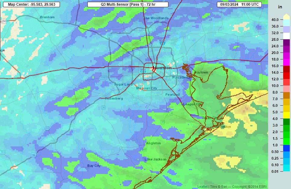
As expected, it was a soggy Labor Day Weekend for coastal areas. Some locations in Galveston Island and Bolivar Peninsula picked up 4 to 6 inches of rainfall on Saturday, Sunday, and Monday after soils were already sodden by last week’s showers. Most inland areas saw considerably less rain over the weekend, although mostly cloudy skies generally kept a lid on high temperatures at about 90 degrees. Healthy rain chances will persist this week, but accumulations should be less for coastal areas. Therefore we are dropping the Stage 1 flood alert that had been in place for those locations.
Tuesday
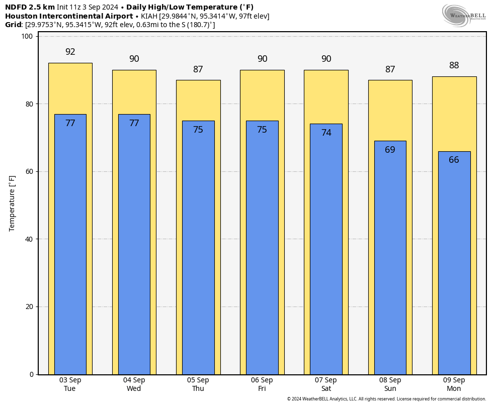
The flow will become a little more northeasterly today across much of the region, and this will tamp down rain chances with one exception. That is, areas south and west of Houston will have access to somewhat more moisture, and we’re already seeing some coastal showers in places such as Lake Jackson and Matagorda Bay this morning. Rain chances will be fairly high in southern Brazoria and Fort Bend Counties, but only in the 20 to 30 percent range for most of the rest of the area. Highs will generally reach about 90 degrees, under mostly cloudy skies. Overnight lows will drop into the upper 70s.
Wednesday and Thursday
With more moisture available, I expect there to be better rain chances for much of the metro area, perhaps 50 percent or higher each day. Still, accumulations don’t appear to be anything crazy, perhaps a few tenths of an inch for most locations with higher totals possible right along the coast. Highs on these days will range from the upper 80s to about 90 degrees, with mostly cloudy skies.
Friday
Look for a partly sunny day, with lower rain chances. Highs will reach about 90 degrees.
Saturday and Sunday
The first half of the weekend should be sunny and warm, with highs around 90 degrees. Drier air, in association with a cool front, should arrive sometime on Saturday or Saturday night. By Sunday morning probably, and Sunday evening at the latest, conditions should start to feel notably drier. As to the effect of this front on temperatures, highs on Sunday will probably max out in the upper 80s, with overnight lows in the mid- to upper-60s for most of Houston. The drier air should last through about Tuesday, which is pretty OK for the season’s first front.
Tropics
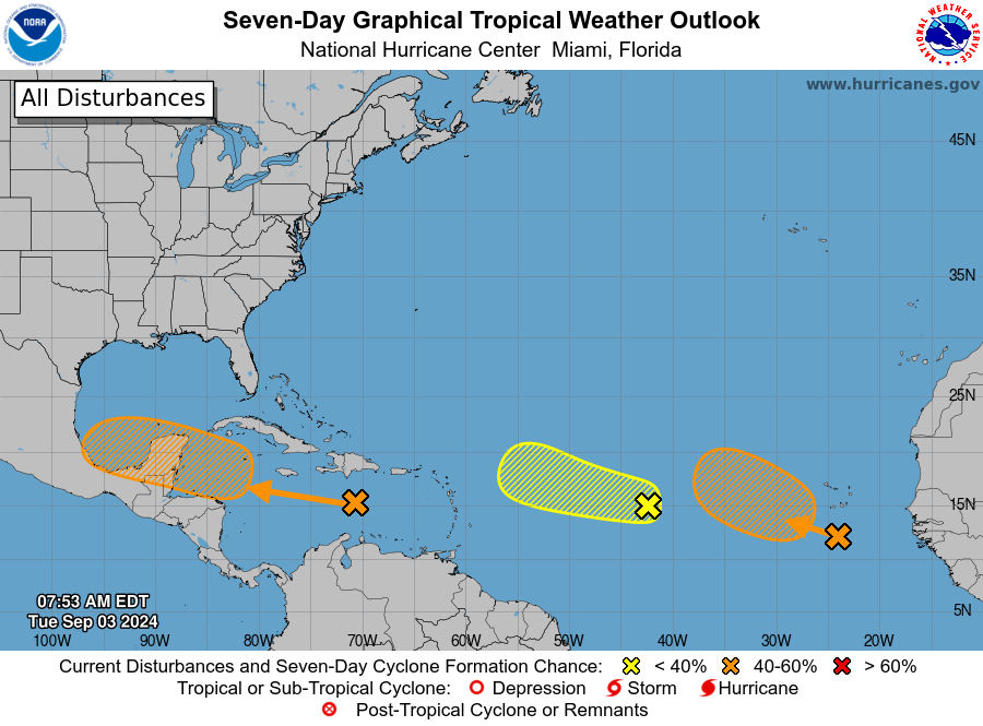
We’re still keeping an eye on some things, and I think there’s a pretty decent chance that we see some sort of activity in the southern Gulf of Mexico about a week from now. But as for threats to the upper Texas coast, I’m just not seeing too much to be concerned about right now. For early September, that is a great place to be.

Dr. Neil Frank used to say that it was very, very rare not to have a named tropical system somewhere in the Atlantic over the Labor Day Weekend. Well we just reached that milestone on a year that was supposed to be “hyperactive”. With that being said it only takes one to ruin your whole day.
‘With that being said it only takes one to ruin your whole day.’
See; Beryl.
How many times are you going to repost that?
Eric/Matt — Thank you for the continuous coverage for the coastal friends who were hammered by the rain. Hope it was manageable for them.
Question for y’all — just southwest of the loop, we had no measurable rain amid the weeklong forecast of pretty good rain chances. What kept that rain out of our area/from being more widespread across the area? What made it an all or nothing event? Was the lower heat working against us, so the storms didn’t fire up inside the city the way they usually do? We also watched a few storms disintegrate before reaching us, and one split into two and went around us. Thank you for any insight.
The weather gods are simply trying to lull us asleep in preparation for a violent late September.
Only got 1 and 1/2 inches all week long in the Westpark/Highway 6 area. Would have liked a little more, but at least it’s something.
Us in Galveston County would gladly share if we could.
That’s so EXCITING about the cool front!
🎃 👻 🎃
Is this particular cold front a good thing or a bad thing for Houston relative to the possible tropical activity in the Southern Gulf? In other words, will this thing create a corridor for whatever develops in the Bay of Campeche to move into Houston?
I’d say any cold front in September is a good thing. It won’t boost any chances for a later tropical development.
Heck, get enough cold fronts sweeping through and it will destroy the heat needed for the storms to feed off of. It just becomes a race: enough cold fronts arriving – or – the tilt of the Earth to take us into less solar heating.
Bonus to more cold fronts: our AC doesn’t have to work as much.
It’s a good thing for Houston – it’s the traditional start to the end of worry about hurricanes for us and the start of Ren Fest & Halloween fun
I’m still waiting to see any rain where I live. And by rain I mean more than just off and on sprinkle showers. Only a tenth of an inch of rain fell in my backyard this weekend while areas just 20 miles south of me saw between 3 and 5 inches. So dumb 🙄
While the cold fronts in the early part of fall do take away some of the oceanic heat, that’s not the main reason why our season ends earlier than the rest of the gulf coast. The cold fronts are brought on by the prevailing atmospheric winds,(troughs) which tend to push away any storm that does attempt to move this way.
That’s why Florida does have to wait until the end of November for its hurricane season to end because they get it basically from any angle except North.
Could this cold front be just a one-off and then we’ll settle into another brief summertime pattern keeping us vulnerable to late September or early October storms?
Who knows, but it is encouraging to see that cold fronts are already showing up in early September,it has been many years since we’ve had that happen.
Perhaps window opening season and AC vacations are right around the corner.
It is possible that we could still end up in a late season summer pattern in late September. Sometimes an early September cool front can lead to a hot muggy miserable mess in late September and even into mid October. The last time we had a decent cool front in early September was in 2017.
Also early season cool fronts don’t always protect us from hurricanes. In 2021 hurricane Nicholas developed off a cool front that passed through us a couple of days before. The front shifted back up to the north which helped steer Nicholas right into Matagorda and Brazoria County. In early October of 1949 a cat 2 hurricane developed off a cool front that shifted back up to the north which sent the hurricane into Freeport. I often bring that one up but it was a freak one off occurrence. Historically we are usually never out of the woods until October. But technically we can’t fully relax until after November
Thanks for digging into the history to remind us how worried we should be. I guess there isn’t enough dark stuff to drag everything down, even with a lot of us still dealing with Beryl fallout.
We were just told a cool front is coming. That is good news in a year where we’ve been dripfed constant anxiety from weather data & sources with very little to break up the painful monotony.
Maybe you should focus on 73 recent years where these occurrences did not happen, instead of the 2 anomalous years where things didn’t go so well.
Turn your weather prowess to the Light Side. It has cookies, too.
Well if it helps you feel any better it is very rare for a hurricane to hit the same location twice in one season. So we got that on our side this year. And there have been way more than 73 years where a freak late season storm didn’t happen here so the odds are greatly on our side my friend. My intention was not to spread fear and panic I promise.
Dan: I think the key to what he said is that in both of those instances the cold fronts shifted back to the north of us. They need to stay south of us.
Cautiously optimistic. I remember in 2013, we had tropical storm activity well into October so I’m not taking anything for granted.
‘Rain chances will be fairly high in southern Brazoria’: if that is the polite meteorological descriptor for the micturition of a female domestic bovine upon a flat rock, I can confirm.
If you mean taking the piss, why not say so?
You have a pet cow? Or did you mistake “bovine” and “canine”?
I am not going to look a gift horse in the mouth. I will gladly and happily take all the September cool fronts that come our way.
As a 66 year resident of Houston, I would rate this as a very nice summer.
More like our summers of 50 years ago. But, our population has increased 5 or 6 fold in the past 50 years along with a huge amount of concrete.