Buckle up! It’s going to be a bit of a ride from the perspective of comfort over the next 24 hours. But that will setup what should be a decent weekend.
Today
This morning has a bunch of mostly light to moderate showers showing up across the region as the first piece of today’s change works through. This is not the cold front but rather what we call a pre-frontal trough, or a dryline. It will deliver scattered showers, light rain, or drizzle, mainly north of I-10. A couple heavier showers or a storm can’t be entirely ruled out to the north of Houston, but no severe weather is expected.
The sun should come out more aggressively by late morning across the majority of the area once this pre-frontal trough nudges through.

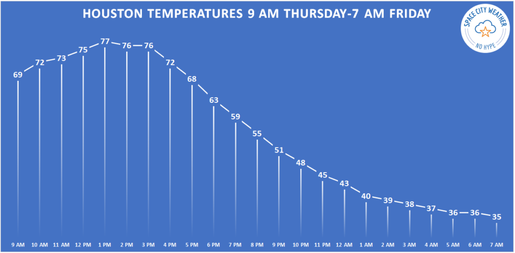
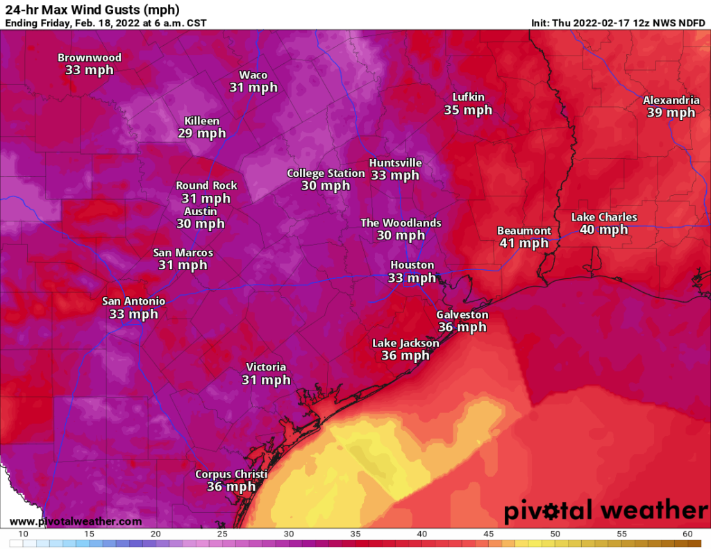
With gusty northwest winds and much lower humidity this afternoon, temperatures will jump up until the actual cold front arrives. Look for that front to get to College Station before 2 PM, the northern & western suburbs of Houston by 4 PM, downtown by 5 PM, and the coast before 7 PM. Give or take an hour or two.
When the front arrives, temperatures should drop 10 to 15 degrees over an hour or two and winds will shift from the west to the north. Before that, we’ll likely see highs into the 70s in most spots, with a chance for upper-70s in the city and south and east of Houston.
Tonight
Once the front pushes offshore, we’ll see a few clouds and continued gusty north winds of 15 to 25 mph. Temperatures will continue to steadily march down, until Friday morning, when most of the region will be in the 30s.

Temperatures could bottom out near freezing in the typical spots well north or west of Houston (Conroe or southwest of Katy/Fulshear). Passing high clouds and the wind will likely limit just how cold most areas can get, so 35 degrees seems to be the cutoff for most places south and 30 degrees north.
Friday & Saturday
After that chilly start on Friday morning, look for high clouds through the day. This will keep temperatures in check a little further, and while mid to upper-50s is the current forecast, we may need to shave a couple degrees off that number if clouds are a little more widespread or thicker. We’ll get another dose of chilly temperatures on Friday night, but it should remain in the upper-30s to low-40s in most spots.
Saturday looks great. Expect sunshine and slightly warmer weather. We’ll march to about 60 degrees or a little warmer with a light wind. Some clouds may attempt to linger south of I-10 at times, but short of that, there should be little to trouble you on Saturday.
Sunday
Clouds will start to push back into the region as winds flip onshore Sunday. Temperatures should still be able to get well into the 60s despite the clouds. A stray shower is possible in the afternoon, especially close to the coast.
Monday and Tuesday
Look for warm, humid weather to settle in for both Monday and Tuesday. Shower chances will push across the area Monday and stay mostly north of the Houston area Tuesday. Temperatures should have no trouble getting well into the 70s, if not back to 80 degrees, especially by Tuesday. Morning lows will be mostly in the 60s.
Beyond Tuesday
A cold front is going to try and push through Houston on Tuesday night, but models disagree about how far it will get. This will have significant impacts on our temperature forecast (the difference between 50s and 70s), and also on our rain forecast. So the forecast on Wednesday and Thursday is kind of a coin flip right now. Look for a more decisive cold front to push through either later Thursday or Friday, and that should usher in somewhat colder air for next weekend.
Matt, can you add comments about frost for us plant lovers (to cover tender plant of not). Difficult to know if we will get frost when it gets close to freezing.
I know, right? And when can I put my plants back outside and leave them! I want to get all this foliage out of my house.
Good morning Matt & Eric,
The girls and I have a special request for Friday’s post: can you please include a weekend forecast for the far northern reaches of Coldspring, TX? Houston ISD’s Baker Montessori PTO has two dozen families setting forth Friday to tent camp in the Sam Houston National Forest. With no urban heat island, I expect the woods will be chillier than our Montrose home, and may even freeze overnight. We will be most grateful (as always!) for your insights. Thanks! Robin
It think you should be able to get this off Weatherunderground’s web site.
Matt and Eric, does it look like rain for cookoff next Thurs – Friday?
It’s not cook-off unless it’s cold and rainy.
True. Prefer cold without the rain this year
The Texas Roller Coaster ride continues…. who needs Six Flags Astroworld?
My sinuses will not be happy with this………..
This is why I live in Texas and deal with the threat of hurricanes in the summer/fall. Give me occasional dips into the mid-30s with daytime highs in the 60s, 70s and 80s. Last week, it felt like we were living in LA…love it.
so tired of all these winds
Jebus
My Sinuses Is On A Roller Coaster 🎢 Ride. Other Than The Winds, I M Good With The Weather.