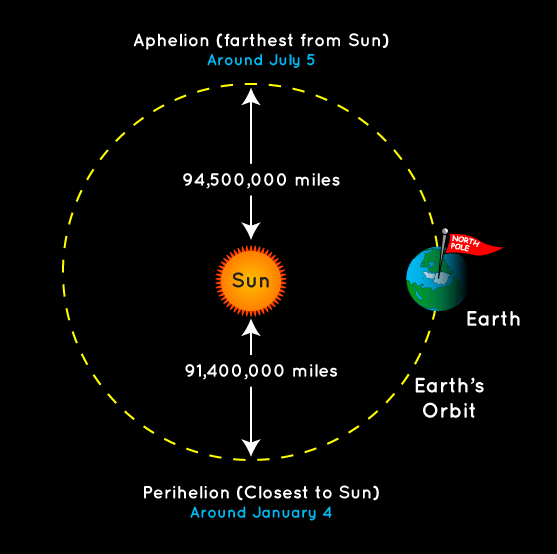
We start this morning with a quick celestial note: Earth reached perihelion at 6:38 pm CT on Tuesday night, meaning it reached the closest point to the Sun in its (slightly) elliptical orbit about our star. Ironically for northern hemisphere residents, though we are closer to the Sun during the winter by a few million miles, it is coldest time of the year. This is due, of course, to the tilt of the planet’s axis rather than proximity to the Sun. We’ll reach our furthest point from the Sun, aphelion, just after midnight on July 5 of this year.

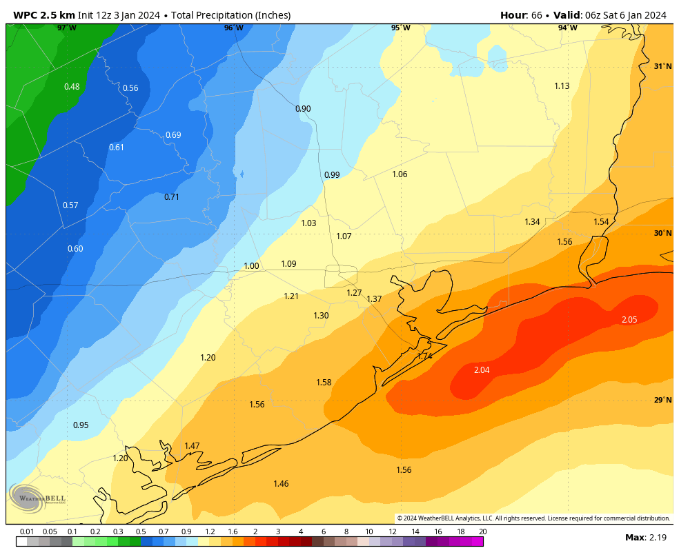
Speaking of weather, rain showers on Tuesday evening and this morning overperformed a little, dropping 1 to 2 inches across most areas south of Interstate 10, with lesser amounts inland. We’ll now see a couple of drier days before rain showers return on Thursday night and Friday. All of this is working toward a gorgeous, winter-like weekend.
Wednesday
Skies will be mostly cloudy today, with highs pushing perhaps into the mid-50s. After some gusty conditions overnight as a coastal low pressure system passed by, winds will be lighter today, generally from the north, at 5 to 10 mph. Lows tonight will be fairly chilly, dropping into the low 40s in Houston, with cooler conditions further inland.
Thursday
This will be a mostly sunny day, probably, with highs in the upper 50s. Winds will be light, generally from the northeast. Another coastal low will be building offshore, but I think its associated rain showers will remain away from the Houston area during the daytime and evening hours. Lows on Thursday night will drop to around 50 degrees, with some light rain possible after midnight.

Friday
This looks to be a wet day, with most of the area picking up between 0.5 and 2.0 inches of rain between early Friday morning and the evening hours. Rain accumulations should be greatest closer to the coast, and the low pressure system. I think the worst of the weather, including stronger thunderstorms, will remain offshore. So I expect this to be a mostly mellow rain event, but it will definitely put a damper on any outdoor plans you have. Look for highs in the upper 50s, and lows Friday night dropping into the low to mid-40s.
Saturday and Sunday
The weekend looks fine and mostly sunny. Highs on Saturday will be around 60 degrees, with overnight lows in the mid-40s, and then a bit warmer on Sunday, in the low 60s. It should be a great winter weekend for outdoor activities. Enjoy!
Next week
A chance of rain showers returns on Monday before a stronger front moves through. This will set the stage for colder mid-week weather, with the temperature likely bottoming out on Wednesday morning. A light freeze looks possible for inland areas, but we’ll have to see as we get closer. Temperatures then warm up again before another front likely cools us down for next weekend. If you’re weather watching for the Houston marathon on January 14, the forecast still looks chilly and dry, but the details remain fuzzy. Nevertheless I’m cautiously optimistic about running conditions!


“… with lesser amounts inland. …”
Yea, no kidding – it rained, maybe, 30 minutes at most, and it was a light shower (up here around Magnolia).
And based on history, I don’t expect much coming in on Friday either. We seem to be in our own weather cavity here.
So far this is a weird winter. My lantana, hamelia, pentas, begonias are still blooming having never lost any leaves or flowers. Normally these plants are dormant by this time. I think we are really moving towards a sub-tropical climate in this region.
I believe the USDA has already started revising the hardiness zones.
This would be a mistake, as in February 2021 and in December of 2022, this area had some of the coldest days that it’s had in years. Anything that grows in Zone 9 would’ve been destroyed during those extended cold snaps.
Then (2021/2022) but maybe not 2024? We shall see.
USDA puts us in 9A….8A would be more appropriate. Maybe one would say 9A works most of the time except for the last 3 years. There’s nothing between Houston and an elongated PV except buildings and prairies. I guess the plant nurseries get a vote and favor overstating our tropicalness.
Due to the February 2021 and December 2022 freezes, all my 60 foot something, 30-year-old palm trees froze to death. To me this doesn’t depict a sub-tropical climate.
Hardiness zones are based on average annual lowest temperatures. I don’t think it froze at all in the winter of 2015-2016. The average of that winter and 2020-2021 would be about 23 degrees, which is zone 9A.
Thank Houston never freezing for the entirety of 2023 (last freeze being Dec. 26, 2022.) The next possible freeze this weekend is just one day before the latest first freeze recorded on January 11, 2016.
Our purely tropical guava is still growing, and our night-blooming jasmine is still putting out flowers. They should have long ago decided it’s too cold for them. Extended temps in the 40s usually make them drop their leaves. We would even still have basil going if we hadn’t needed to remove them finally for the winter crops. Those usually die back in early October!
I just noticed my beauty berries are throwing up new berries.
Obliquity > proximity.
So, on July 5, we can take some scant comfort by knowing it could have been even hotter if the earth wasn’t at aphelion. Like a million and one degrees rather than the normal million degrees.