In brief: Houston jumped back into the mid-90s on Monday, and that’s where we are going to be for awhile as high pressure dominates our weather this week. Aside from the heat, which will be high but far from exceptional for this time of year in Houston, we have few concerns. This post will also discuss the tropics, which are awakening from their mid-July slumber.
Tuesday
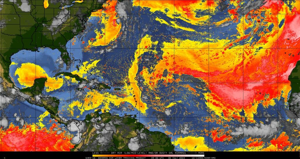
The main difference today, from Monday, is that we’ll see a slightly better chance of some showers and thunderstorms this afternoon. It’s definitely just a puncher’s chance, with perhaps 10 or 20 percent coverage, but you may hear a few rumbles later today. We should also start to see the onset of some haze later today, due to Saharan dust that has traveled all the way across the Atlantic. This should pose no health concerns, and is beneficial for our soils. Sunsets should also be great this week.
High temperatures today, like on Monday, will push into the mid-90s for most locations away from the coast. Skies will be partly to mostly sunny. Winds will be from the south at 5 to 10 mph, with a few gusts of 15 mph or higher this afternoon. Low temperatures should briefly drop into the upper 70s tonight, away from Houston.
Wednesday and Thursday
These will be a pair of hot and sunny days, with high temperatures mostly in the mid-90s, but with the possibility of some inland locations sneaking into the upper-90s. Winds will be from the south at 5 to 10 mph, but Wednesday at least should see some slightly gustier conditions during the afternoon hours. Rain chances are likely 10 percent or less. Haze should be most predominant on these days, so if you look up, you’ll be staring into African dust. It’s a big world, but it’s also a small world.
Friday
Our weather for this week will mostly be guided by a high pressure system. However, by Friday or so, that system should begin to back off a bit. This may introduce a slight chance of showers, perhaps on the order of 20 percent or so by Friday. Otherwise, expect mostly sunny skies and highs in the mid-90s.
Saturday
The first half of the weekend looks to bring sunny skies, with high temperatures generally in the mid-90s. If I squint I can see the possibility of some rain showers, but overall chances are around 10 percent or less. It should be a good beach day after a long period of not-great summer weekend weather. I can’t believe school starts in just a couple of weeks.
Sunday, Monday, and beyond
As mentioned above, as high pressure backs off a bit, we should see some slightly cooler weather—think lower- to mid-90s rather than mid- to upper-90s—and some daily rain chances in the ballpark of 20 to 30 percent daily. Skies still look to be partly to mostly sunny, for the most part. All in all, this weather looks to be fairly benign for early August in Houston, typically the hottest time of the year.
Tropics
Speaking of non-benign things, as we get into August the Atlantic tropics start to heat up. Matt has got you covered on the Eyewall when it comes to a tropical wave that could threaten the Bahamas, and maybe eventually Florida. As for the Texas coast, there are no concerns from that system, nor anything else at this moment. Let’s hope things remain that way.

Following up on something I asked last week — City of Houston was out spraying for mosquitoes late Sunday night as a truck rolled through the hood — the first time I’d heard that in a few years IIRC — and it knocked them back a bit before last week’s rain-induced crop arrives, so hopefully they’ll be doing that across the city for folks.
The GFS is showing a system just to the east of us around August 7th – it’s not the first time it’s done that recently and it’s within the 10 day window. What’s up with that?
I want to know that too…
With that said, accuracy goes way up when these systems form a center? Meaning we have to wait..I’m prepared as much as I can afford…
I’m old..
Cannot afford to buy shutters or have somebody plywood my windows, cannot afford a home generator or even a portable one..Cannot afford to move north…My very small house is paid off and I do not want to have to deal with a mortgage in my 80s and 90s..I’m not destitute enough to qualify for help from the city or from faith communities around our area, but not healthy, rich or strong enough to do all this work myself..
Our preparation strategy has always been to rent a room away from the hurricane impact zone if the potential landfall is near our city, then come back when it’s safe enough to do so..Through the years we have counted on weather media to give us enough of a heads up, so that we can pack up and find a safe place without having to do a last minute scramble..
Lisa, did you have problems with Beryl? If not there should be no reason to fret about another system which seems not to be a threat to us anyway. As for preparations: we don’t plywood our windows or use shutters or have a generator. Most people don’t and survive with no problem. Try not to worry over stuff like this.
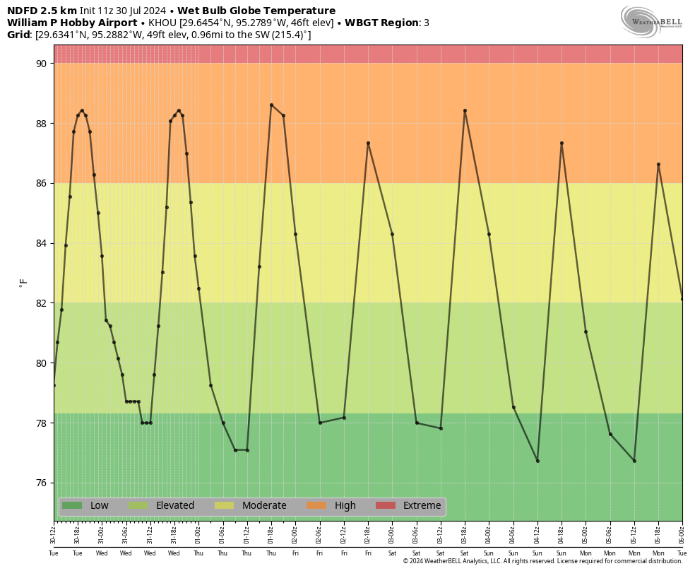
After last year, seeing a WBGT chart that has the “extreme” category in a narrow band at the top rather than taking up half the chart, I’m good with this August so far.
Can confirm I was in the 10% for rain. Stepped outside to a blue morning sky + downpour because there was a single dark cloud rolling through our neighborhood. I didn’t particularly want to win the rain lottery today though!
We actually had an 8 day stretch without a 90 degree day where I live. That is practically unheard of for July. I’m not complaining. So far I will take this summer any day over the 4 months of brutal heat with no let up that we had last year.
your statement that the Saharan dust is not health concern is not really rue..
“The dust can exacerbate some respiratory issues, such as asthma, or certain allergies. Senior adults and young children are also particularly vulnerable to inhaling the tiny particles. Where concentrations are high enough, people may experience nose, throat and eye irritation as well as coughing.” please check your sources
Living life will engender health concerns. Try not to be an alarmist.
True, no one gets out of this life alive. Best to get whatever pleasure there is whilst still living.
Is there a chance you could put a like to the eyewall site on the space city weather app during hurricane season? I use my phone to access the app and would love to come to the app for both instead of bookmarking. Both are so valuable when it comes to Houston’s crazy weather. Y’all are the best in the business. If it’s already there I can’t find it. I can only find links in posts. I like to check out both even if the eye wall link isn’t in a post.
Re: the Saharan dust not posing health issues. Doesn’t it typically cause upper respiratory problems? Are you saying that this is a lighter “dusting?” Thanks!
How long are we expecting the dust to be in area?