In brief: Just a few thoughts to share on Tropical Storm Beryl tonight—basically some things I’ll be looking for on Sunday. If you’re looking for a nuts-and-bolts forecast of what impacts to expect in Houston on Monday, please see our post from earlier today, which holds up fine tonight. We’ll have a comprehensive update for you first thing in the morning.
When will Beryl start intensifying again?
As of late Saturday night, Beryl remains a high-end tropical storm with 60 mph winds. Its intensity has not changed much today, as expected, due to shear and entrainment of dry air. However, as we’ve been discussing, Beryl is moving into a more favorable environment tonight and on Sunday, and therefore it is virtually certain to re-strengthen.
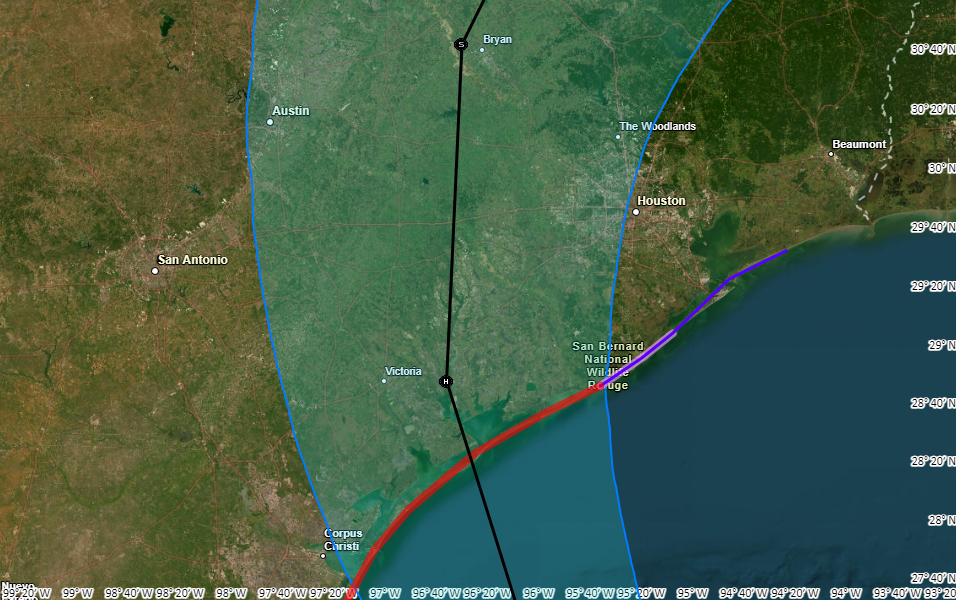
One key question at this point is when Beryl starts to rev back up. This is because once Beryl starts to increase its winds, it likely won’t stop intensifying until it runs into Texas. So on Sunday I’ll be watching to see how soon Beryl’s winds start to increase, and how fast its central pressure (currently 993 mb) starts to fall.
The National Hurricane Center forecasts Beryl to come ashore as a Category 1 hurricane, with 85 mph winds. However, the forecasters there acknowledge that Beryl could rapidly intensify in the final hours before it comes ashore as the system reaches an environment with significantly lower wind shear. In addition, historically, we have seen hurricanes intensify as they near the Texas coast. The bottom line is that the later Beryl starts intensifying, the better, as it could easily become stronger than a Category 1 hurricane.
A silver lining: Beryl is moving at a good clip
One bit of good news is that the storm is moving a bit faster than expected, so it will have less time over water to get going. Some of our best models, including the European and GFS models, now bring the storm to the Texas coast around 2 to 4 am CT on Monday, several hours faster than previously thought. This will give Beryl less time to rapidly intensify.
The forward motion will also help with rainfall totals, both at landfall and after it moves onshore. Houstonians are justifiably jumpy when it comes to inland rainfall from hurricanes after Harvey, and this storm will make landfall only a little way up the coast from where Harvey did. But Beryl is no Harvey. In fact, the forecast for Beryl’s forward motion after landfall is also trending faster. So while I do expect to see some very intense rainfall in the Houston metro area on Monday, increasingly it looks as though the heavy rain will exit to our north by Monday night or early Tuesday.
We should have better clarity on Beryl’s impacts in Houston by tomorrow, as we’ll be less than a day before landfall. The bottom line is that everyone in the Houston area, but especially residents south and west of the city, should be prepared for heavy rainfall and higher winds on Monday. How much rain, and how strong the wind will be is something we’ll try to fully pin down in tomorrow’s forecast. This will, of course, depend to some extent on the rapid intensification (or not) of Beryl discussed above.
Have a good night, everyone.

Do we have idea of when the non-hurricane but unpleasant to drive through or pick up yard furniture rain will start up? Currently out of town and trying to figure out how early we need to peel out of here knowing we have some outdoor prep before the evening.
We’re going to see some intermittent heavy rain on Sunday, but the seriously organized stuff will hold off until at least early Monday I think.
Thanks for the update Eric!
As always, thanks for the timely info, the reasoned message, and the calm delivery.
Thanks Eric!! Have a great night!!
I’m preparing for 50+ mph winds at my home on the west side of Houston near Beltway 8 and Westheimer. Anything loose or wind-prone is being picked up and stored indoors.
What does the blue line represent? Current variability in center line of storm? Or hurricane force winds? Something else?
The blue line is the “cone of uncertainty,” in which the storm track is likely (but not certain) to remain.
What is the “s” on the line by Bryan, TX?
tropical storm
S-storm
The “S” denotes a tropical storm by that point on the map, the “H”, further south on the map, denotes hurricane status at that map point. Per the graphic, Beryl is expected to downgrade from hurricane to tropical storm while on land somewhere between the H & the S.
Get a good night rest, tomorrow night we dine in hell
I keep telling myself this will all be over in 48 hours …
And that can still feel like an eternity.
Thank you
The title of the article is hilarious, Eric; you missed your calling :-).
Yes! Thanks for this late evening update. You definitely are THE authoritative source for weather now (like you didn’t know this already)
Let’s hope we’re not replacing a fence next week, neighbor.
My flight to Houston is supposed to land at 9 or 1am On Monday. I have to be at a very important meeting at noon in Houston. Should I change my flight to Saturday night instead?
You most definitely should. And you should make sure that meeting is still taking place.
I am flying in to IAH on Tuesday at 10:30 PM. Do you think this will be okay?
When I was looking at the future track for the storm earlier this evening, they had it moving into Arkansas as a disorganized low pressure system by Tuesday evening. If that forecast holds, I think you shouldn’t have any concerns.
You’re surely not seriously asking about changing your flights to Saturday at 11pm on Saturday night. If you are, your very important meeting in Houston will be just fine without you making it in person.
Thank you for keeping us updated!
would somewhere north of houston, like the woodlands, be far enough aaway to evacuate if we’re in galveston?
From the map above, it appears that Humble and Kingwood along SH 59/ I-69 Freeway would be better places to hunker down than The Woodlands on I-45.
Thanks so much. THE go to site for Houstonians!
Thanks for the update Eric.
This afternoon you sounded iffy on the forecast track. How are you feeling about potential “wobbles” now?
What are your thoughts about Monday commutes? I work in the med center and commute from Sugar Land. I do work in an outpatient setting so it’s not emergent care.
so for those (like me) who are stuck in Galveston, what do you think happens when it comes to the town?
Thank you, Eric! Hope you get some rest. And thank you for the grace about the Harvey PTSD that still lingers for so many.
I am so grateful to you and Space City Weather; your title of tonight’s storm update is inspired – yeah!!
Always grateful for your clear, straightforward, and informative updates. Also dig the Katrina and the Waves nod. Gotta have some humor!
Thank you guys so much for your work. It brings great comfort.
We have a flight leaving hobby at 7:30 Sunday
If you were guessing would that still be ok?
7:30am or 7:30pm?
7:3 pm
That’s really a question for your airline, not SCW.
So we are a little south of yall, in Port lavaca… are we still expecting us to be getting the worst of this? And if you were here, and still struggling to finish prep but planning on cutting and running tomorrow what would be your guesstimate as to need to be done and ready to hit the road by what time?
This is such a silly title. I love it.
Kind of poor taste mentioning Katrina and this storm in the same headline, IMO.
Opinions! Everyone’s got ‘em! IMO.
Katrina and the Waves was a band; ‘Walking on Sunshine’ was their biggest hit. Didn’t you know that? The headline is brilliant.
Thank you for your update Eric. It is truly helpful. My family and I are vacationing in California right now. I can’t help but think of everyone back home and also our home. When you say West of Houston does this include areas like Hockley? Also worried about our car which is parked in the ecopark at Bush.
What can be expected with Beryl in terms of rain and wind for those NE of Houston?
My husband is supposed to drive to Dallas from Clear Lake early Monday morning… is that stupid? Seems stupid 0.0 Maybe time to reschedule?
Yes it is stupid. At the very least it would be an insanely stressful drive.
We have to wait till tomorrow or is there any prediction on how widespread n how long power will be out and how many tornadoes beryl is going to spawn? Power is rather vital living in satans armpit for 6+ months out of the year in 98-110* heat for least 5 of those months. Wish I could move to where my friend lives, ND. Last I checked it was 72* there, practically paradise compared to here. Nonetheless, would like some forecast on if its gonna be hours or days without power.
There is no way to predict what you are asking…
Power will be out for precisely 11:24:38 for those who don’t evacuate Katy. One F0 tornado within 100 miles of Humble.
Oh, and I have a bridge for sale – any bidders?
NWS has not changed the track much over the past 24 hours. Let us in Houston metro hope it stays out west, stays relatively weak and we just get some blustery winds and some rain. But if the worst happens, I have loaded up on the essentials from my favorite store that begins with S and ends with pec’s.
I’m way more nervous about the winds than the rain. Just hoping I won’t be 2 weeks without power like I was after Ike.
unless rapid intensification occurs, it is highly doubtful Beryl will be anything like Ike was. Ike was a huge category 3 hurricane when it came onshore.
Is driving in from San Antonio on Monday afternoon going to be a bad idea? Hoping we’d miss the worst of it by then, but not quite sure about timing.
That timing couldn’t be any worse. With the current track you’d basically be driving when the eye is passing over I10 as a low Cat 1 or a severe tropical storm. If the strength of the storm doesn’t change wildly you might be able sneak through late Monday night like 9-10 pm but remember you’ll be driving through an area that could have debris on the road and block you from making it back etc.
How about Richmond TX? How bad would it be? Thanks in advance
Thank you for keeping us informed!
Thank you for keeping us informed. Appreciate the humor…we need it at times like these.
Stay safe everyone.
Bit of stretch to say pass “near west side of Houston”.. Map shows it’ll pass over Columbus, TX which is 40 miles west of Katy. Columbus is 80 miles inland too. And 1 day out the path won’t jump much. Katy and rest of H likely won’t feel high winds, so “west side of Houston” is safe.. Now if was heading to Katy even inland then West side of Houston would feel it lots.
Current point of the track crossing IH-10 is 2 miles east of Sealy. Observed on the Weather Channel app at 9:30am.
Give credit to the one weather guy in Orlando that said Htown hit ….seven days ago. He was watching the H move to FL and reason for spin from MX to TX.
I am a full-figured fella who is thinking of flying a kite on Monday around noon. What are the chances that I will be lifted airborne?
My husband has a flight from NY landing in Houston. At 8:30am, what are the chances this gets canceled??
8:30am on Monday