Good morning. It was a bit of a noisy night last night across much of the area at various times. Rain totals were quite variable. Most of the inner part of Houston saw 1 inch or less of rain overnight. Northern Harris County north through Montgomery County saw 1-3 inches of rain. Coastal areas got hit by a second complex of storms and saw 1 to 3 inches south of Houston with up to nearly 4 inches in Galveston.
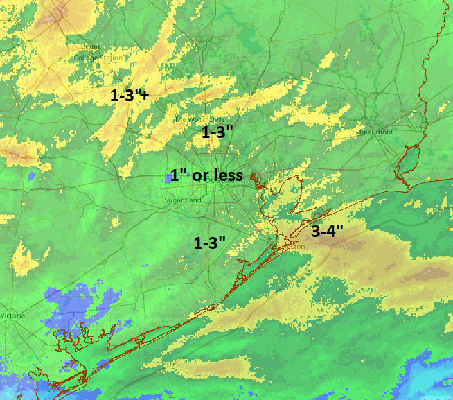
You can view more rain totals from the Harris County Flood Control website. While the night didn’t go exactly to plan, the end result was mostly in line with expectations and nearly everyone saw rain.
Rest of today
The atmosphere is pretty worked over after last night’s storms, so those will actually work to help us have a mostly decent day today. I am hopeful that we see some sunshine break out this morning from west to east. We’ll then possibly cloud up again heading into the afternoon as the cold front approaches. A few showers or an isolated thunderstorm will be possible as the front passes. But I think most areas will stay calm today. We should manage the 80s for highs this afternoon, with pretty high humidity. It’ll feel a little soupy.
Saturday
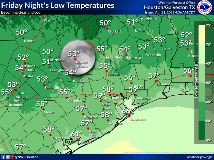
Everything continues to look great tomorrow. We expect sun, comfortable humidity, and temperatures warming from the 50s (or low-60s) well into the 70s.
Sunday
We’re continuing to watch a vigorous disturbance for Sunday that will likely pass comfortably south of Houston. That being said, rain chances are going to build up across the area, but especially south of the city during the afternoon. These breakdowns are approximate and if you fall “on a line,” don’t read into either too much.
For the City of Houston and points north: Expect clouds and some sun on Sunday. Morning lows will generally be in the 50s to near 60, and we will warm up in the mid-70s. Humidity will be a little higher Sunday but by no means oppressive. Showers are likely to break out during the afternoon hours, especially the closer you get to I-10 or highway 59/I-69. A thunderstorm can’t be completely ruled out either.
For places south of Houston: Expect mainly cloudy skies with showers and thunderstorms developing on Sunday afternoon. Chances for heavier rain and more widespread thunder will be close to Matagorda Bay. As you go north or up the coast from there, rain chances will gradually taper from widespread to “scattered.” Some of the storms could be strong to severe on Sunday, especially as you get closer to the Corpus Christi area.
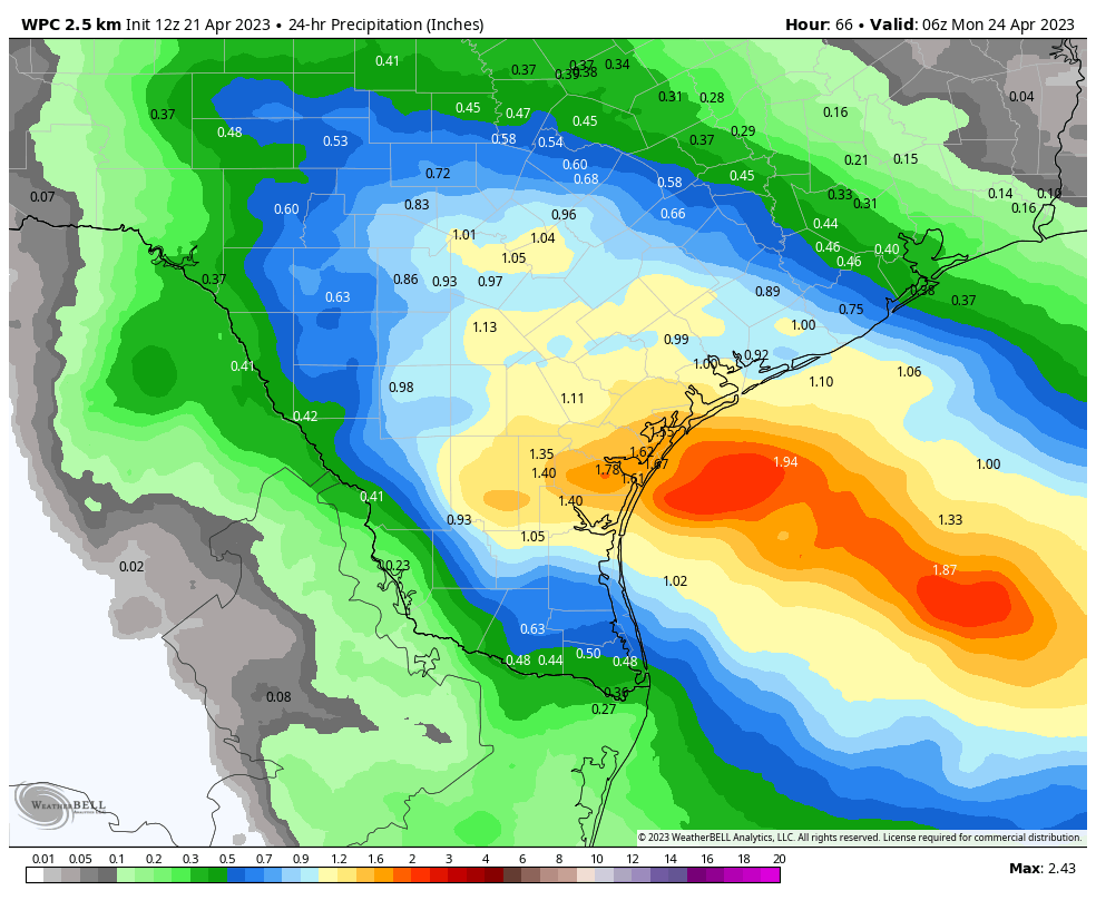
Rain will be heavy as well with 1 to 3 inches possible south of Matagorda Bay. Anyway, the bottom line is if your travels take you south of Houston on Sunday, you’ll want to be aware of this. Outdoor plans in and around Houston will clearly be a bit hit or miss.
Monday
This looks like a calmer day with just a very slight chance of showers or a storm. Look for highs in the 70s and morning lows in the 50s and 60s.
Tuesday
Details on how Tuesday will play out are fuzzy, but it’s safe to say that rain chances are notably higher versus Monday. Expect at least scattered showers and storms. It will be warmer and more humid, with highs near 80 and lows in the 60s.
Wednesday
The atmosphere may need to recover from leg day on Tuesday, so rain chances look a bit lower here. We should temps into the 80s with some sun, while AM lows struggle to get much below 70 degrees.
Thursday
Cold front day? Shower and storm chances will increase again here, as we see a cold front approach the region. Again, it’s too soon to figure out details. But it appears we’re going to see scattered storms at the least. This should hopefully setup a nice weekend for the MS150 and any other events around the region. But, we still have a few days to watch things.


Thank you for giving us MS150 weather updates
In Sienna Steep Bank Village area, it was a very busy night. At 1:00 am we got about .26″ of rain in about 15 minutes (1″/hour rate). Then somewhat steady but light rain for next few hours, with another .22″ falling between 1:30 and 4:00. At 4:15, the big disturbance reached us. We got another 1″ of rain in about 20 minutes, with a peak rate of over 5″/hour. Thunder, lightning, but not really any bad winds. So overnight, we have roughly 1.5″ of total rainfall, my corn crop is flattened by the rain, and I will not have to add any water to my pool to make up for evaporation of the past week or two.
Going out to see if I can salvage my corn plants 🙂 . I hope everyone else survived okay as well.
I will also add that at our house, the Excitable Dog Index rating of 8/10 that you gave was spot on. Our little dog Coco thought the world was coming to an end at 4:30 am, with the thunder and lightning. .
Bellville; my front porch; 2″ of rain in the gauge during the night.