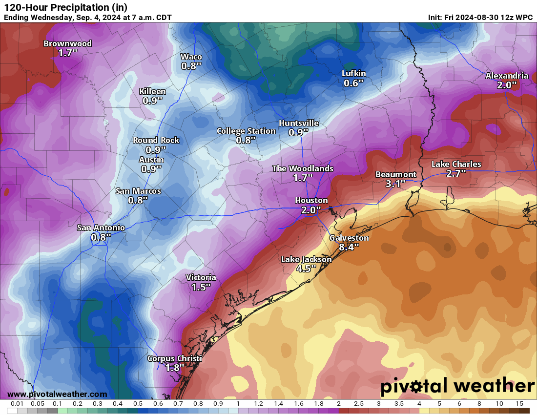
In brief: Periods of showers and storms will meander through the region over the holiday weekend. While most places should handle this fine, there remains a chance that coastal areas, especially between Chambers County and Port Arthur see some very heavy rainfall, requiring us to maintain our Stage 1 flood alert for coastal counties.
Rain thus far has been very scattered across the area. Just about everyone has seen a little, several places have seen a moderate amount (1 or 2 inches), and only a handful of places have seen a lot (about 4 inches). This pattern will continue, and we’ll maintain a Stage 1 flood alert for the coastal counties out of an abundance of caution. This does not include Houston proper or points north and west. This is one of those difficult cases to communicate. Modeling continues to flag the Port Arthur area into eastern Chambers County as a potential focal point for very heavy rainfall heading into the weekend. At the same time, we’ll probably just see periodic, manageable scattered downpours in Houston. But because there’s an element of risk near our area, it merits decent coverage. We’ll be with you through the holiday weekend as needed for updates.
Today
Radar this morning shows a lot of rain offshore and along the coast.
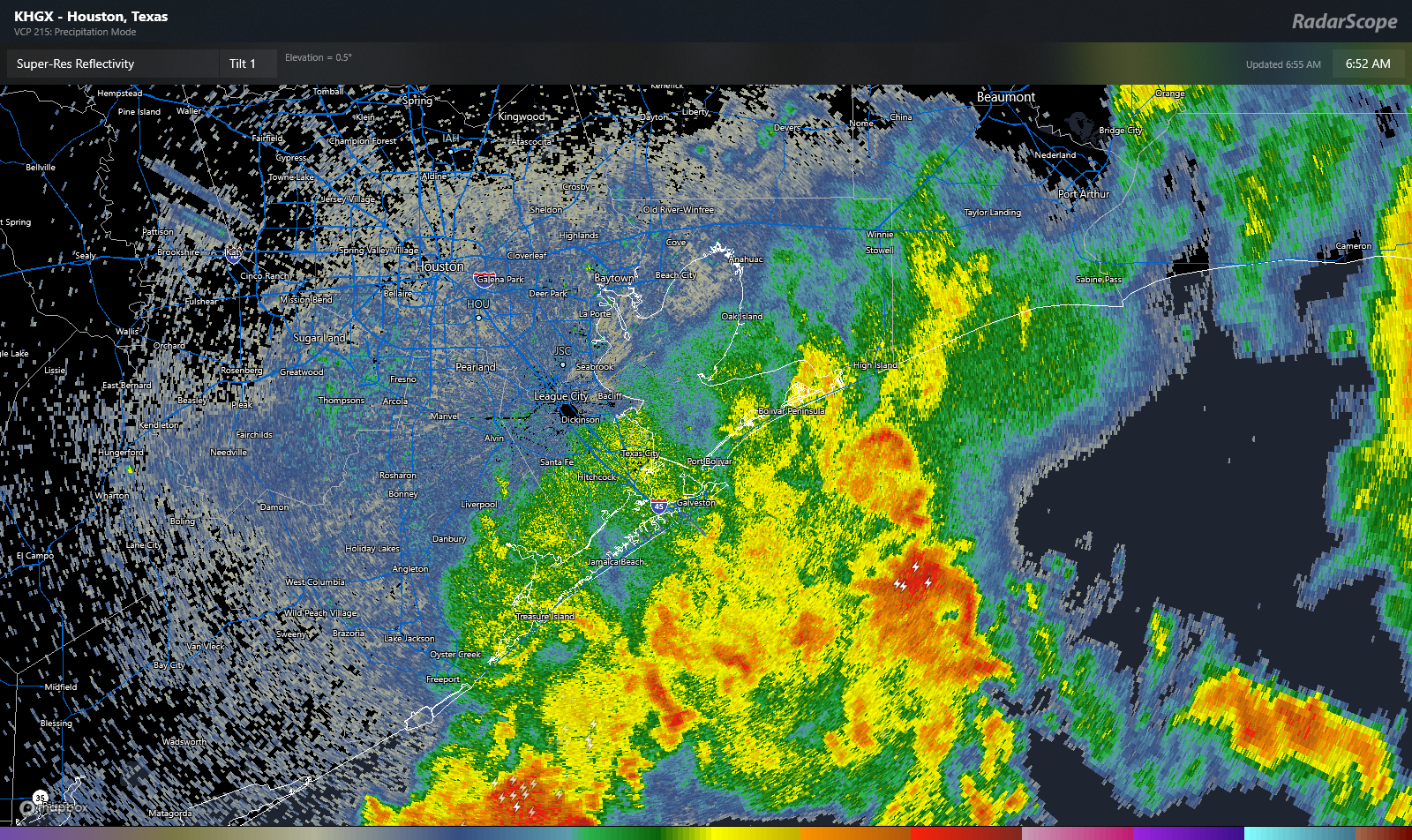
This was all generally moving parallel to the coast and more toward the eastern Chambers and western Jefferson County areas. I would expect to see showers pop off today around Houston eventually. However, with all this rain offshore, sometimes this tends to “rob” inland areas of any moisture. So all in all, it may not be too bad of a day in Houston and points north and west. So expect more just “passing” showers today and probably a good deal of cloud cover. Highs will be in the 80s in most places to low-90s north and west of Houston where more sun is likely.
Saturday & Sunday
There will continue to be a healthy chance of passing showers and storms both days this weekend ahead of the holiday. Neither day looks like a total washout, but there could be abundant clouds at times, and you’ll obviously want some backup plans in case rain hits your location for a time. Other than that, it will remain warm and fairly humid with highs in the upper-80s to low-90s and morning lows in the upper-70s.
Labor Day & Tuesday
Copy and paste the weekend, but with perhaps just slightly lower rain chances.
Rest of next week
We’ll likely continue to see daily shower and storm chances continue Wednesday, Thursday, and Friday, but the setup may continue to gradually become a little less impressive. This may mean a little less coverage with each successive day. There continue to be rumors and allegations of a cool front next weekend. A cool front in early September means a drop in humidity, slightly cooler nighttimes, and hot daytimes. So, don’t get too worked up just yet. Much like Eric suggested yesterday, about a 25 percent chance this happens seems reasonable, though I will say that modeling has been nothing if not persistent with this signal since as far back as at least last weekend. Fingers crossed!
Tropics
Before we even dive in here, one cold front does not mean the end of hurricane season here in Texas. I looked at the data for this last year and determined no correlation. So, we do still need to keep tabs on the tropics.
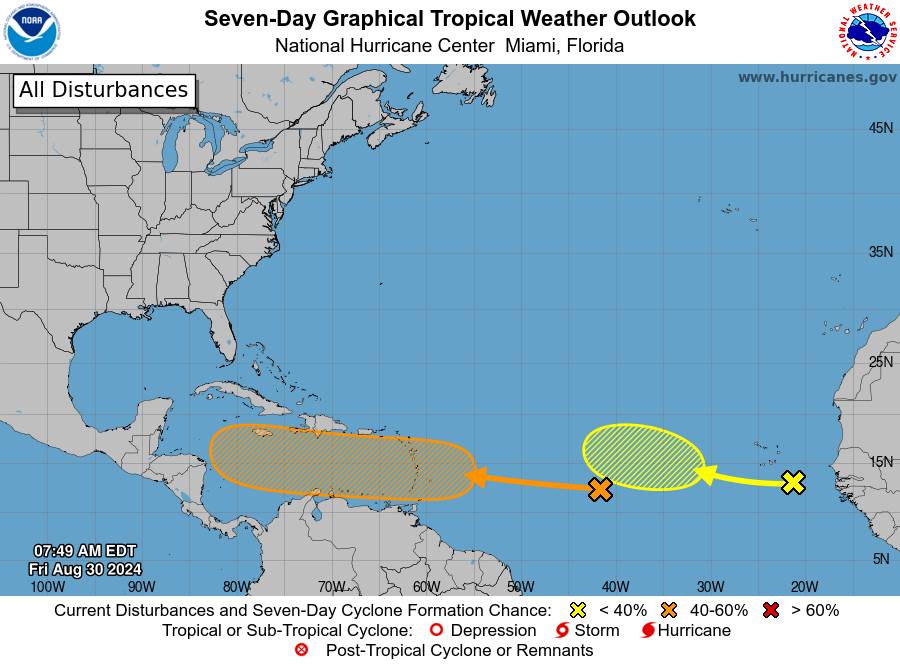
The disturbance in the Atlantic is likely going to track into the Caribbean. As of right now, most model data supports a turn to the north at some point. However, where that occurs is impossible to say right now. It’s still early in the game here, so let’s keep an eye on this as it comes westward over the next week or so. Behind that there is another development candidate, and that too should hopefully turn north before getting too far west. So, for now we don’t have any serious threats here. But stay tuned. I’ll cover this more in depth at The Eyewall later.

Yeah we’re getting bullseye’d aren’t we?
yep sure seems awfully familiar…
“..a drop in humidity, slightly cooler nighttimes, and hot daytimes…” I’ll take it!!! A high of 95 that feels like 95 actually is not a bad deal!
If we do get a hurricane will it be around Sept 8-10?
Looks to be making near landfall on the 11th according to certain models. It has creeped more towards the Texas coast with each update.
It’ll be the second worst disaster to happen on September 11th.
Stop living and dying by each model run. This is why models should only be available to the experts.
Too late. Already moved to Montana.
What site are you using to look at models?
“..one cold front does not mean the end of hurricane season here in Texas. I looked at the data for this last year and determined no correlation”
I reject your reality and substitute my own
Each day the models are showing that system in the Caribbean inch it’s way here. Peak season is upon us.
Long range models will continue to change over time. Best to wait until an actual named storm forms to start making assumptions
At the SW corner just below the loop, each of the rain storms that have approached since Tuesday have disintegrated before we get any rain, and yesterday, I watched the radar as the cell coming from the east literally broke apart and went around us on both sides. I’m convinced a neighbor has a lightning rod or similar. Would love a little rain for the trees and the yards. That said, the evening air has been magic with dare I say a slightly cooler/less hot breeze. So while we’ve missed out on the rain, we’ve enjoyed its effects and are grateful for that. Stay safe for the long weekend, all!
We must live around the same area. It was so disheartening to see that storm cell break apart and go north and south of my dead lawn. According to the flood control district site, we have gotten 0.08 inches total from all of this 😭
So Heather, you live just below the loop. Well as I pointed out yesterday, I live here Santa Fe and I’d like to have a dollar for every time a rain cell approaching us and then literally breaks apart, or parts and goes around us on either side. My wife and I are both puzzled as to what’s up with this, since it happens most of the time. Dickenson is only around 3 miles to the north of us and they seem to get about 80% more annual rainfall a year than we do and I’d certainly like to find out why. As I stated yesterday, there’s has to be a reason for this and I’d really appreciate an answer.
I love that you used the word “meander”.
How to say you’re from the south without saying you’re from the south. 😏😎❤️
Not taking any chances. Going to go ahead and evacuate this weekend.
Out of an abundance of caution, I gather? LOL
GFS is certainly stirring up something nasty for Ike’s 16th anniversary……
It looks like this area of low pressure in the gulf is moving east which means we are on the dry west side. My area has barley received much rain at all these past few days. I do not expect to get anymore rain worth a crap this weekend. The forecast models are being a little generous in my opinion.
I feel your pain Drought hater: You can see the post above which I just made to Heather.
Yes, I definitely understand that. I live in Western Brazoria County near West Colombia, and it seems like, more times than not, scattered storms miss us. Not always, though. It’s like all or nothing where I live. We either get flooded, or we get little trash showers. I’m not sure why your town gets missed all the time. You might just live in a really unlucky area. Scattered sea breeze storms tend to develop right along the immediate coast and can lose a lot of steam as they travel further inland. The rain-cooled air that collapses from these scattered storms cuts off the warm humid updraft and kills the storm. This often happens right by my house. Ironically enough, this rain-cooled air can help more storms redevelop just a mile or so past my house. That could be the case with Santa Fe. It can be pretty frustrating when you are in a drought. It can seem like there is an invisible dome over your city. That is the only scientific reason I can think of why Santa Fe frequently gets missed by storms.
Hoping that there isn’t another hurricane or tropical storm coming this year. The storm in May and Hurricane Barrel were quite enough for one year.
I understand the need to punt occasionally but this site has held a pretty steady mantra over the years:
The first fall cold front pretty much marks the end of the hurricane season for Houston.
Then from above:
“Before we even dive in here, one cold front does not mean the end of hurricane season here in Texas. I looked at the data for this last year and determined no correlation.”
The two seem to oppose one another…
The sort of cold front which causes the morning outside air to be noticeably cooler than the air inside your house is the type that signals the tropical storm threat slowdown. The one which may happen next week is no more than a wind shift bringing in less-humid air. The upside is that this could be a signal of an earlier succession of the stronger type than we usually get (me on hopium).
This morning, Mike at Fox26 Weather repeated what he has described as a circular rain system (2-3 days now) in our local Gulf waters.
And now, the NHS has put another on their map – we now have three disturbances for the Atlantic region and our immediate Gulf area … this for our Gulf area:
Formation chance through 48 hours …low … 10 percent.
Formation chance through 7 days …low …20 percent.
They mentioned the possibility of a surface low developing just offshore on The Eyewall blog a day or two ago.
Yea, but it’s now “official” via NHS 🙂
Anyway, checking radar now, it looks to be more bothersome for Louisiana folks, so no worries.