This month we’ve got a jam-packed SCW Q&A for you, with topics ranging from the eventual demise of La Niña to mysterious high tides to a new forum where you can talk weather, 24/7! The latter is also where you can now leave questions for this occasional Q&A series. Let’s get to it!
Q. I’ve heard a lot about the La Niña weather pattern that the US is apparently in. It indicates that we will have a warm and dry winter with above average temps. What is your realistic take on our upcoming winter? Will we ever have freezing temps or not?
A. So yes, La Niña conditions are currently present in the equatorial Pacific Ocean. This means that sea surface temperatures in the region are mostly below average across the area. According to the latest forecast from NOAA, issued last week, La Niña conditions are likely to persist through winter, with a transition to ENSO-neutral conditions likely in during the January to March time frame next year. Predicting precisely when just is not possible.
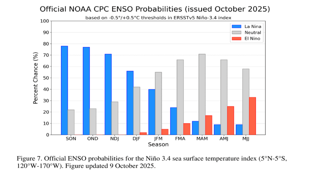
Assuming that a moderate La Niña is in place this winter, what does that mean for Texas in general, and Houston in particular?

La Niña’s largest impact lies in how it affects the jet stream. I’ve discussed in the past the mechanics of the jet stream, and how important it is to Texas weather. In a normal winter, the jet stream drives low pressure systems and cold fronts down from Canada and into the southern United States. La Niña limits the southern extent of the jet stream, minimizing the number and intensity of those cold, rain-laden fronts we typically see. This means Texas could see a drier, warmer winter than average, if typical La Niña patterns play out. Of course we have had some of our very coldest snaps during some recent La Niña winters, so this should not be treated as an absolute certainty.
– Eric
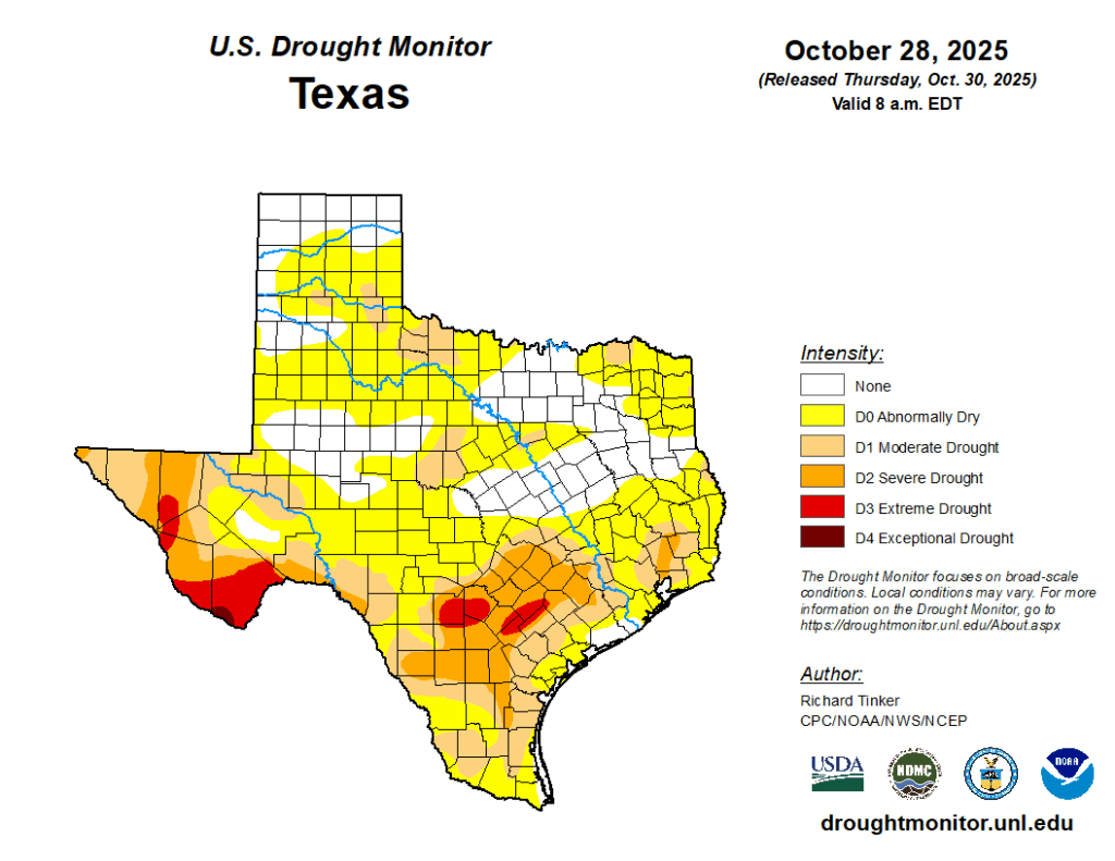
Q. It feels like we are in a drought. What conditions must exist for meteorologists say “we’re in a drought” and what conditions must be met before an area comes out of the drought?
A. Generally, Matt and I rely on the U.S. Drought Monitor to determine drought conditions locally and nationally. They characterize the intensity of drought from “none” to “exceptional drought.” As of this week (with data through Monday, October 27) a little more than half of the Houston area is “abnormally dry” and a little less than half is in a “moderate drought.” If you’re interested in the methodology behind the drought determination, more information can be found here.
Another good resource is the climate page of the Houston/Galveston office of the National Weather Service. They have lots of good resources, but among my favorite are snapshots of annual rainfall totals compared to normal levels. From this it is pretty clear that the Houston region has been building up a rainfall deficit since early August. That is pretty consistent with the time I started watering my grass this year.
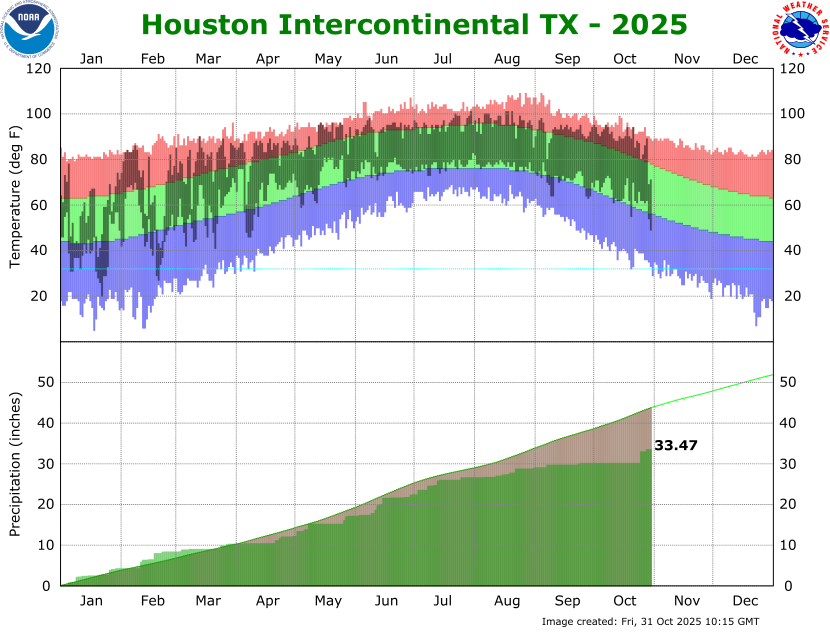
Note, also, you can see a spike in rain totals associated with recent rainfall. It put a dent in our annual deficit, but only a small one.
– Eric
Q. I was visiting Houston and realized that the sky is blue at night. It’s not very dark like in nyc. Do you know why?
A. Interesting question! I don’t know the precise answer, but I would guess that one reason the sky over New York City at night appears to be a different ‘color’ or ‘tint’ than Houston is due to the presence of a larger number of skyscrapers and their bright lights in the Big Apple.
As for the blue color at night, that is largely due to the increased use of LED lights. Before about a decade ago, the vast majority of street and building lights were sodium-vapor lamps, which appeared more orange and yellow-ish. LEDs are much more efficient in terms of energy use. And they emit light at a shorter wavelength, in the blue-white portion of the spectrum. Shorter-wavelength light is scattered more efficiently. This leads to more bluish light bouncing around the lower atmosphere.
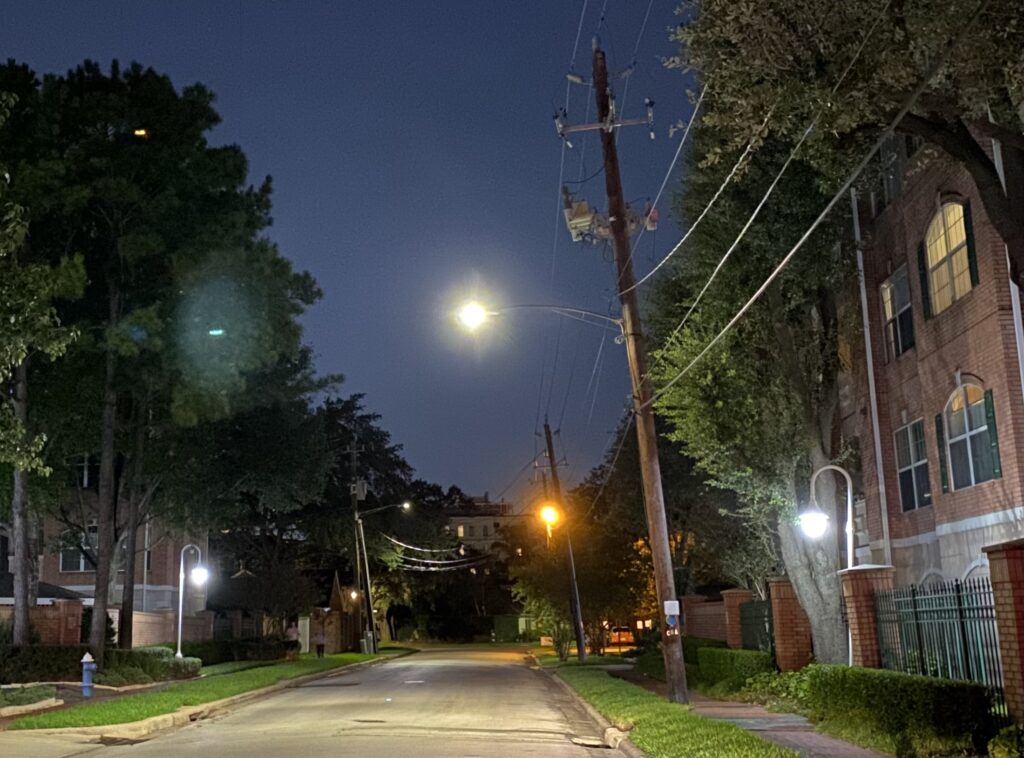
Houston is also generally more humid than New York, and this extra humidity makes the effect more intense (water vapor in the atmosphere increases scattering).
– Eric
Q. We have had a lot of ozone days late summer / early Fall ( or at least it seems like it ). These days are usually drier in humidity and gorgeous. I’m pretty sensitive to the air quality. Even as far inland as Tomball it still affects me. Winds are from NWnot from SE( city of Houston air ) . What weather factors play into Ozone days? Lightwind, sun? Wind direction?
A. We do have a lot of ozone action days in Houston. Over the last 10 years, we have averaged about 37 per year. Just to refresh people’s memories, when we discuss “ozone action days,” we aren’t referring to the ozone layer in the stratosphere (or good ozone); we are discussing ground ozone, which forms through chemical reactions between nitrogen oxide and what we call “volatile organic compounds,” or VOCs. In plain language? The pollution emitted by cars, power plants, refineries, chemical plants, etc. will chemically react in sunlight to produce ground-level ozone.
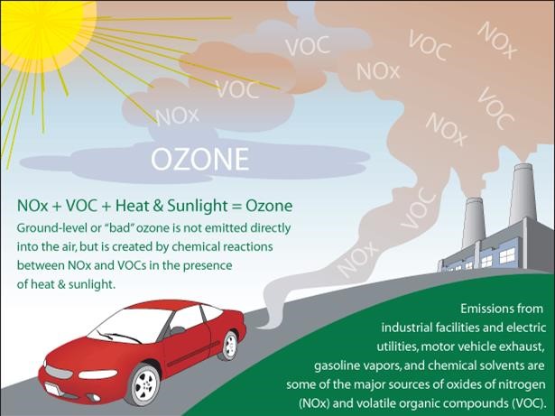
The reality is that some of the nicest days in Houston can be marred by pollution because maximum sunlight and clear skies usually follows cold fronts, ushering in lower humidity. You’ll see most of our ozone action days in autumn and spring behind cold fronts or sometimes behind winter fronts. We can also get them in summer when we have stagnant high pressure and minimal daytime thunderstorms. While it does tend to improve the farther you get from the population (Harris County) or industrial (Galveston County) centers, because Houston sprawls so much and so far, ozone issues can extend far into Harris County and even just beyond. Wind direction does not play much of a role, but cars, industry, and sunlight do.
– Matt
Q. We recently got an alert warning of coastal flooding potential while in Galveston. It was a strange sight considering we were used to seeing flood warnings before a storm, but rain wasn’t anywhere in the forecast. Yet, we encountered times where the beaches in the west end had no accessible sand because the tides were so high and our rented beach house had flooded roads. What caused this sudden high tide spree? A friend claimed it was a “noreaster” which popped up on my feed affecting the east coast, is that effectively a hurricane for side effects to other coastal areas? What gives?
A. Ah, the joys of living on the Gulf Coast. Blue sky flooding is a fairly common problem, and it has gotten to be more common due to the combination of sea level rise due to climate change and land subsidence as we pull groundwater out of aquifers.
The day you’re speaking of was a day of what we call “king tides,” which are the astronomically highest tides of the year. Basically, the predicted highest tides in any year are king tides. We know when those will occur. But this year, we also had what we call a “long fetch” (more fetch than “Mean Girls”), which is to say easterly winds pushing across the length of the Gulf from Florida to Texas, which helped elevate tides a little more. The combination of king tides and the winds helped cause some coastal flooding without a drop of rain.
The number of days of flooding in Galveston annually began increasing pretty significantly around 2015, peaking in 2020. We used to average about 5 or so back in the early 2000s and prior. We now average closer to 15 days a year. With continued sea level rise and ground subsidence, the number of days of routine high tide flooding without a storm nearby is likely to increase to perhaps as much as 30 to 40 days a year on average in the 2030s and beyond that in the future.
– Matt
Q. We like the new commenting system, but each category closes after a day. Is there a place where we can just chat in general about the weather? Or ask weather questions?
A. We’ve been getting more comfortable with Discourse as our commenting system, and now that things have settled down, we’re going to try out having a discussion area where people can talk about more general weather-related topics. Please feel free to try out the Weather Talk category!
Unlike the Space City Weather or The Eyewall categories, anyone can start a thread in Weather Talk, and discussions will stay open instead of closing in 24 hours.

We’d like to keep things focused on the weather rather than having free-ranging discussions, so please make your discussions weather-related! There’s a welcome post in the new forum with some more details on how we’d like things to go, so please check that first.
You can also use this forum to post questions you’d like to see in our regular Q&A feature (like this one!). When we get ready to post a new Q&A, we’ll scan that category for your queries. Got a question you want to ask now? Head over to Weather Talk!
– Lee & Dwight