In brief: Today’s post discusses sea fog, of which there is plenty near the coast this morning. Beyond that, the forecast is proceeding pretty much as expected, with much warmer-than-normal weather for February expected through Saturday. Some sort of cold front arrives later on Sunday, probably, to bring somewhat cooler weather.
Sea fog
The closer you live to the coast, the greater the chance you’re experiencing sea fog this morning. This is caused by warmer air—such as we’re experiencing now, with air temperatures of about 70 degrees near the coast—moving over somewhat cooler nearshore waters in the Gulf. This fog forms when warmer air moves over the cooler waters, and the air temperature falls to the dew point temperature, saturating the air.
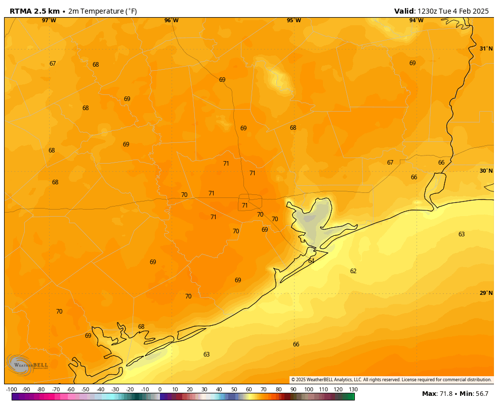
A dense fog advisory is in effect until 9 am this morning, with visibility is some locations low as one-quarter of a mile. If you’re driving in this, please leave a little more space between vehicles, and use your low-beam lights. With warmer weather this week, fog will be possible in coastal areas through Friday or possibly even Saturday morning.
Tuesday
As noted in Monday’s forecast, the weather this week will vary little from day to day. We’ll see a persistent onshore flow all week, and this will lead to a warm and consistent pattern. High temperatures today will reach about 80 degrees, with partly sunny skies. Winds will be from the south at 5 to 10 mph. With dewpoints in the 60s, the air will feel somewhat sticky. Lows tonight will only fall into the upper 60s for most of the metro area.
Wednesday, Thursday, and Friday
Rinse and repeat. Expect warm days in the vicinity of 80 degrees, with partly to mostly sunny days, and mostly cloudy and warm nights. We can’t entirely rule out rain chances, but they’re quite low, perhaps on the order of 10 percent each day.
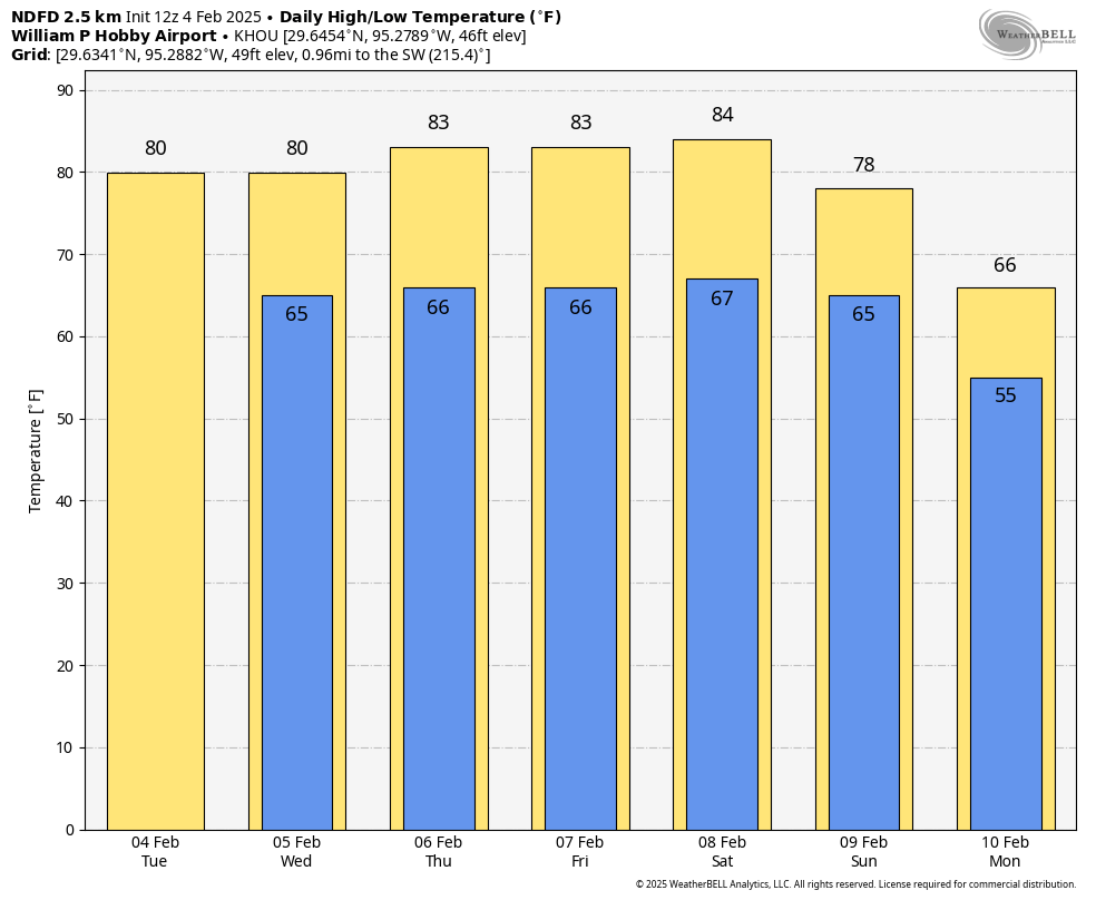
Saturday and Sunday
The first half of the weekend brings more of the same, however it now appears likely that some sort of front will push into the metro area on Sunday. The timing and strength are still to be determined, as well as the likelihood of rain with the front. At this point I’ll predict high temperatures in the low-80s on Saturday, a warm night, and highs near 80 degrees on Sunday with a modest chance of rain. Lows on Sunday night will fall into the 50s. All of this is in pencil, mind you.
Next week
With uncertainty about the strength of the front, and possibly a secondary push of cooler air mid-week, I don’t feel too confident about what to expect next week, except to say that it probably will feel more like February than this week does. I also think we’ll see more clouds and better rain chances. But as ever, the long-range details are fuzzy.

This week sucks
Dry weather lets me finally get progress on my patio project! The evening breezes are definitely refreshing though…
This is winter in the era of global warming. It is either bone chillingly cold or disgustingly warm and humid with very little moderation between the two. The warm days are outnumbering the cold days by a large margin every winter now, another symptom of a warming planet.
Wow, if the thermometer can get to the mid 80’s in early February, its no wonder we can get ridiculously hot in the summer. For those of you new to the area, this is your red flag.
February 20, 1986, 91 degrees.
Yep and also 90 on February 22nd 1996.
Hoping for a mild front! Nice and boring! ☺️
Same
mid to high 80s are back on the menu bois!
Mid 80s on Saturday really? 🤦♂️. This will be the 3rd February in a row that we have had a week of highs in the 80s. Man I hate global warming!!
I read that the winds in Antarctica have become stronger recently due to temperature differentials.
It seems like the winds in the last few years have become stronger everywhere, esp since 2020 when the shipping emissions were cut & we lost our smog blanket. Maybe that’s why we’re seeing the noticeable unpleasant difference in wind & storm activity of all sorts. What irony.
Winter is over and here comes the hot, steamy, muggy summer. Ugh!
We really haven’t caught much of a break this ‘winter’.
Nope just 3 weeks of chilly and cold weather. Now for 49 weeks of miserable heat and humidity before a couple of weeks of cool weather next January 🙄🤦♂️