In brief: Houston’s early February warm spell is bringing record high temperatures and plenty of sea fog, and this pattern is unlikely to change before at least Sunday. And even then there is some uncertainty about the timing and strength of a front that will be moving down toward Houston.

Unseasonably warm
We’re starting to set some fairly serious heat records with this present warm spell. The high temperature at Bush Intercontinental Airport on Tuesday afternoon reached 84 degrees, smashing the previous record of 81 degrees for the city of Houston, set during 1957. The city of Galveston, too, eked out a new record of 75 degrees, besting a mark of 74 degrees originally set way, way, way back in 1890 (and subsequently tied in 1957). With a very warm southerly flow in place for the remainder of the week, we can expect more records to fall in the coming days.
Wednesday
Warm air temperatures are continuing to contribute to the development of sea fog across coastal areas, as this air moves over the cooler Gulf waters. In addition, we’re seeing some light, misty rain in coastal areas. If you’re driving through the soupy air, take a little extra time and give the car ahead of you a little more space. This fog should dissipate between 9 and 10 this morning. Afterward, highs today will reach around 80 degrees under mostly sunny skies. Winds will be from the south at about 10 mph, with higher gusts. Lows tonight may briefly drop into the upper 60s.
Thursday and Friday
The warm pattern continues, with sea fog possible in the early morning hours. Highs will be in the lower 80s, with mostly sunny skies and southerly winds. Nights will be warm, in the upper 60s.
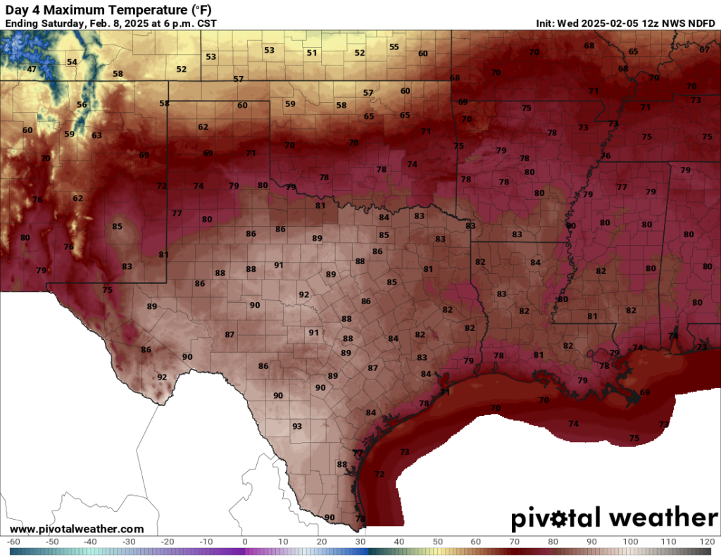
Saturday and Sunday
We can be confident in the weather for the first half of the weekend. It will be warm, with partly sunny skies, and highs in the lower to possibly mid-80s, pushing record levels. (This is moderately amusing because about 10 days ago you may recall some social mediarologists telling us about an “Arctic blast” coming through during the weekend of Saturday, February 8). A weak front will approach the Houston area on Saturday night and Sunday, but it remains an open question as to whether the front will make it all the way into Houston proper. Accordingly my best guess is that highs reach about 80 degrees on Sunday, but there’s some uncertainty around that. As the front stalls, we may see a few scattered showers.
Next week
At some point next week a stronger push of cooler air is likely to come down, but how strong and how long it lasts remains to be seen. Perhaps we’ll see a night or two in the 40s.

I’m so tired of the phrase ‘record highs’
inb4 I’m told to move. (I mean if you wanna pay for it that’s cool. Hit me up.)
The term “record high ” is starting to lose all its meaning because it happens all the time now. Record highs used to actually mean something because they were an anomaly that didn’t used to happen very often. Now we see record highs all year every year, and we have even been tying or beating record highs set just a few years ago. Record lows, however, have become a very rare occurrence. This is par for the course in a warming world
GROSS x 1000
Guess I won’t be using the Aquanet today…
Houston Closets:
Everything, Everywhere All at Once.
one week I need my heavy fleece and mere days later am digging out shorts and tank tops
Just washed some Summer clothes. I don’t WANT to wear them! Waa Waa LOL Can we please just have a few more weeks in the 50s and 60s?!
Ugh… and it’s only February.
And just think, it will only get worse in the coming years. By the 2030s we will probably start seeing weeks of highs in the 90s in February.
Thanks for ‘mediarologists.’ I read some of those predictions, and smiled, having learned from SCW that 14-day forecasts based on single models and hope are relatively untrustworthy.
Love the term “mediarologists” and will definitely be stealing it!
Grrroooooooossssssssss
Oh wow, I didn’t even see Other Ashley’s comment, lol
Haha great minds and names 😂
Yeah!
It’s crazy to me how many bugs came out recently. There’s a loud hum of insects in the trees already, and I killed a mosquito the other day. The cold and then record warmth seemed to convince everything that spring was here…
Another lovely thing to look forward to in a progressively warming climate, more bugs!! 🐛🪲🐞
The fire ants in particular are out of control right now
THIS. I wondered if the snow woke them up.
My trees are yelling at me recently. wow they are loud this year.
You may need to see a doctor about that, my friend.
The current weather pattern of record warmth in December followed by a blizzard (literally just to our east)in January ensued by more near record warmth in February is eerily similar to the crazy weather described in the book “The Little Ice Age: How Climate Made History 1300-1850” by Brian Fagan. Especially when you consider the fact that over the last nine months we experienced a Derecho, Hurricane, a mini drought and heatwave in addition to the near blizzard…
I know we live in Houston and all of these things have happened in the past but the weather over the last nine months seems to be hyper volatile. Perhaps this is a sign of some bigger climate shift? One caused, partially caused or influenced by man? Maybe just a natural cycle shift like the one described in Fagan’s book? Maybe just weather? But it “seems” like things are changing…
Hyper volatile is right
It’s climate change except it’s not natural this time like the other changes in the past. It’s from our excess greenhouse gas emmisions warming the surface of Earth up more and more over time. This is throwing the jet stream patterns all out of wack, leading to the shap swing between extremes that we’ve been seeing for years now.
Sure there is still some natural variability at play, but the effects of global warming are adding extra fuel to extreme weather events now and making them more likely.
Yep
“Mediarologists”!! Love it!
“Mediarologists” made me laugh out loud. I may steal that. A Facebook friend a week or so ago posted a map with a front and a RED arrow pointed directly at Houston. They did the same thing during hurricane season. I’ve watched with interest the overnight lows for next week. Nothing approaching what the fear peddlers want us to believe.
Social media is all about clicks, likes and shares. Unfortunately headlines sell and dramatic thumbnails are a sign of the times.
Only in Texas can it be snowing with temperatures in the teens and then 2 weeks later in the 80s and 90s. 🙄
It’s not that different in other places. Here in the mountains of New Mexico two weeks ago we had -11 and multiple low single below days, the last three days it’s hit 60 degrees and only cooled to the upper 20’s at night. I’ve lived here long enough to have seen this pattern repeat itself several times. Dought will soon follow, at least here, I’d bet my last buck on it.
Yes, but you have the mountains and the scenery and the wide open spaces to comfort you. We have ‘traffic’.
Anyone who lives here can stand outside at 6 in the morning and listen to the overwhelming roar of traffic from the various freeways and the beltway. It’s awful!
What do you expect? the area is a coastal plain built on marshes and its flat land. Just an expanding concrete jungle
“Anyone who lives here can stand outside at 6 in the morning and listen to the overwhelming roar of traffic from the various freeways and the beltway.”
Hmmmm. We don’t hear any of that, just birds and crickets and such.
Oh, wait, we’re up in a Magnolia acreage area – no intrusive freeways, traffic 🙂
Everyone has the option to get away from the big city 👍
“Everyone has the option to get away from the big city”
Nonsense! Do you think if everyone moved to Magnolia you would be in the country any longer? Give thanks we don’t all move there.
In any case, how many acres do you actually have (asking for a friend), you say often enough you live on ‘acreage’.
I often hear people say they are going to their ‘ranch’ over a weekend and it usually turns out they only have an acre or two – not enough for a single cow and certainly not big enough to be called ‘a ranch’.
We have seen record heat in the 90s across parts of Texas with no clear end in sight in February, and Australia just had a record heatwave. Gee, it’s almost like there is a rapid warming trend going on with the climate because of our endless co2 emmisions, and maybe we should do something about it but the deniers will still say that nothing is wrong and global warming is fake. Drill Baby Drill!!
Yeah. Fubar.
So, was all that talk about colder weather coming over the 2nd half of February just a bunch of hogwash?
2nd half is more like the 14th
Back in the day having a week of highs in the 80s in February was like a once in a decade anomaly but now it’s happening every year. Infact, 80 degree days in general have been happening much more often during the winter months here since 2017. It seems like what the scientist have been saying is correct.
If we get more heat out of the way early in the year that means less heat left for the summer months, right? 😀
Ha ha if only it worked that way 😅
Absolutely. We only get a certain ration of heat in a year and once that is used up, it is then pure mild bliss!
It’s ridiculous the lack of moderation between the extreme temperatures these days. We go from blisteringly cold pipe, bursting freezes to feeling like May a week later. It’s just so dumb. 🤦♂️
Wonder what caused the high temps in 1890?
A similar weather pattern to what we are seeing now. Interestingly enough, the winter of 1889-1890 was the warmest winter on record in Galveston and still is I think.
Now add in the growth that this and other areas have seen since 1890 and it’s no surprise we are getting warmer. Add to that burnt orange paint bombs on weather maps plus social media and you get hysteria.
Ah, but you should have been here in 1236-1237, good grief, it was hot.
“..1889-1890 was the warmest winter on record ”
Hah, you think that was a hot winter!
You should have been here when they were creating this place, the heat then was biblical.
February 2017 vibes.
Facts!
Why is the fog called sea fog, instead of gulf fog, since we don’t have a body of water designated as a sea?
It’s what’s referred to as a “generic term”. Check Wikipedia:
A sea is a large body of salt water. There are particular seas and the sea. The sea commonly refers to the ocean, the interconnected body of seawaters that spans most of Earth. Particular seas are either marginal seas <==== “marginal seas” link leads to:
Later:
This is a list of seas of the World Ocean, including marginal seas, areas of water, various gulfs, bights, bays, and straits. In many cases it is a matter of tradition for a body of water to be named a sea or a bay, etc., therefore all these types are listed here.
The refusal to accept basic scientific research when it conflicts with what we prefer to believe is why our civilization won’t survive or current human-driven climate change.
The 90 degree days of March are just around the corner, at which point Houston will once again become an unbearable swamp until November.
The weeds are already sprouting on my lawn. Generally I have waited til after Valentine’s Day for the weed and feed, but I am too late this year.
A+ on “mediarologists.”
They have said that this particular Volcanic eruption probably contributed a little to the warming seen in the past 2 years, but it was small in comparison to the warming caused by our CO2 emissions over time.